Passonfontaine
| Passonfontaine | |
|---|---|
| Commune | |
 | |
 Passonfontaine Location within Bourgogne-Franche-Comté region  Passonfontaine | |
| Coordinates: 47°06′31″N 6°25′10″E / 47.1086°N 6.4194°ECoordinates: 47°06′31″N 6°25′10″E / 47.1086°N 6.4194°E | |
| Country | France |
| Region | Bourgogne-Franche-Comté |
| Department | Doubs |
| Arrondissement | Pontarlier |
| Canton | Valdahon |
| Intercommunality | Pays de Pierrefontaine-Vercel |
| Government | |
| • Mayor (2008–2014) | Stéphanie Paen |
| Area1 | 19.49 km2 (7.53 sq mi) |
| Population (2012)2 | 294 |
| • Density | 15/km2 (39/sq mi) |
| Time zone | UTC+1 (CET) |
| • Summer (DST) | UTC+2 (CEST) |
| INSEE/Postal code | 25447 /25690 |
| Elevation | 715–960 m (2,346–3,150 ft) |
|
1 French Land Register data, which excludes lakes, ponds, glaciers > 1 km2 (0.386 sq mi or 247 acres) and river estuaries. 2 Population without double counting: residents of multiple communes (e.g., students and military personnel) only counted once. | |
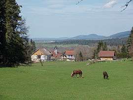
Passonfontaine is a commune in the Doubs department in the Bourgogne-Franche-Comté region in eastern France.
Population
| Historical population | ||
|---|---|---|
| Year | Pop. | ±% |
| 1962 | 277 | — |
| 1968 | 290 | +4.7% |
| 1975 | 229 | −21.0% |
| 1982 | 217 | −5.2% |
| 1990 | 193 | −11.1% |
| 1999 | 227 | +17.6% |
| 2008 | 274 | +20.7% |
| 2012 | 294 | +7.3% |
See also
References
| Wikimedia Commons has media related to Passonfontaine. |
This article is issued from
Wikipedia.
The text is licensed under Creative Commons - Attribution - Sharealike.
Additional terms may apply for the media files.