Les Fourgs
| Les Fourgs | ||
|---|---|---|
| Commune | ||
 | ||
| ||
 Les Fourgs Location within Bourgogne-Franche-Comté region  Les Fourgs | ||
| Coordinates: 46°50′06″N 6°24′22″E / 46.835°N 6.4061°ECoordinates: 46°50′06″N 6°24′22″E / 46.835°N 6.4061°E | ||
| Country | France | |
| Region | Bourgogne-Franche-Comté | |
| Department | Doubs | |
| Arrondissement | Pontarlier | |
| Canton | Frasne | |
| Intercommunality | Mont d'Or et des Deux Lacs | |
| Government | ||
| • Mayor (2014 –) | Claudine Bulle-Lescoffit | |
| Area1 | 27.99 km2 (10.81 sq mi) | |
| Population (2012)2 | 1,267 | |
| • Density | 45/km2 (120/sq mi) | |
| Time zone | UTC+1 (CET) | |
| • Summer (DST) | UTC+2 (CEST) | |
| INSEE/Postal code | 25254 /25300 | |
| Elevation | 899–1,242 m (2,949–4,075 ft) | |
|
1 French Land Register data, which excludes lakes, ponds, glaciers > 1 km2 (0.386 sq mi or 247 acres) and river estuaries. 2 Population without double counting: residents of multiple communes (e.g., students and military personnel) only counted once. | ||

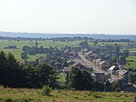
Les Fourgs is a commune in the Doubs department in the Bourgogne-Franche-Comté region in the eastern part of France.
Population
| Historical population | ||
|---|---|---|
| Year | Pop. | ±% |
| 1962 | 710 | — |
| 1968 | 742 | +4.5% |
| 1975 | 753 | +1.5% |
| 1982 | 806 | +7.0% |
| 1990 | 941 | +16.7% |
| 1999 | 1,058 | +12.4% |
| 2008 | 1,175 | +11.1% |
| 2012 | 1,267 | +7.8% |
See also
References
| Wikimedia Commons has media related to Les Fourgs. |
This article is issued from
Wikipedia.
The text is licensed under Creative Commons - Attribution - Sharealike.
Additional terms may apply for the media files.