Frasne
| Frasne | ||
|---|---|---|
| Commune | ||
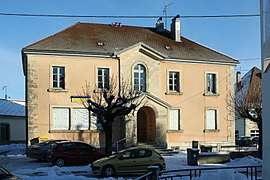 Post office | ||
| ||
 Frasne Location within Bourgogne-Franche-Comté region  Frasne | ||
| Coordinates: 46°51′23″N 6°09′37″E / 46.8564°N 6.1603°ECoordinates: 46°51′23″N 6°09′37″E / 46.8564°N 6.1603°E | ||
| Country | France | |
| Region | Bourgogne-Franche-Comté | |
| Department | Doubs | |
| Arrondissement | Pontarlier | |
| Canton | Frasne | |
| Intercommunality | Plateau de Frasne et du Val du Drugeon | |
| Government | ||
| • Mayor (2008–2014) | Philippe Alpy | |
| Area1 | 32.87 km2 (12.69 sq mi) | |
| Population (2012)2 | 1,876 | |
| • Density | 57/km2 (150/sq mi) | |
| Time zone | UTC+1 (CET) | |
| • Summer (DST) | UTC+2 (CEST) | |
| INSEE/Postal code | 25259 /25560 | |
| Elevation | 810–882 m (2,657–2,894 ft) | |
|
1 French Land Register data, which excludes lakes, ponds, glaciers > 1 km2 (0.386 sq mi or 247 acres) and river estuaries. 2 Population without double counting: residents of multiple communes (e.g., students and military personnel) only counted once. | ||
.svg.png)
Frasne is a commune in the Doubs department in the Bourgogne-Franche-Comté region in eastern France.
The local railway station, Gare de Frasne, was opened on 10 June 1855.
Population
| Historical population | ||
|---|---|---|
| Year | Pop. | ±% |
| 1962 | 1,367 | — |
| 1968 | 1,353 | −1.0% |
| 1975 | 1,430 | +5.7% |
| 1982 | 1,355 | −5.2% |
| 1990 | 1,519 | +12.1% |
| 1999 | 1,624 | +6.9% |
| 2008 | 1,789 | +10.2% |
| 2012 | 1,876 | +4.9% |
See also
References
External links
| Wikimedia Commons has media related to Frasne. |
- Website of the village www.frasne.net (in French)
This article is issued from
Wikipedia.
The text is licensed under Creative Commons - Attribution - Sharealike.
Additional terms may apply for the media files.