Nova Granada
Nova Granada (Portuguese for "New Granada") is a municipality in the northern part of the state of São Paulo, Brazil. The population is 19,180 inhabitants (IBGE/2010),[1] and the area is 533.49 km². The elevation is 542 m.
Nova Granada | |
|---|---|
 Flag  Seal | |
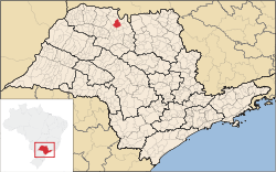 Location of Nova Granada | |
| Coordinates: 20°32′02″S 49°18′51″W | |
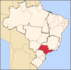
| Country | |
| Region | Southeast |
| State | |
| Mesoregion | São José do Rio Preto |
| Government | |
| • Mayor | Aparecido Donizete Martelli |
| Area | |
| • Total | 531.9 km2 (205.4 sq mi) |
| Elevation | 542 m (1,778 ft) |
| Population (2010/IBGE) | |
| • Total | 19,180 |
| • Density | 36.06/km2 (93.4/sq mi) |
| Time zone | UTC-3 (UTC-3) |
| • Summer (DST) | UTC-2 (UTC-2) |
| Postal Code | 15440-000 |
| Area code(s) | +55 17 |
| Website | Nova Granada's Prefecture |
The city belongs to the Microregion of São José do Rio Preto.
History
From the expansion of coffee in the North of the state of São Paulo, many settlers started to form farms, increasing the number of residents in the region. Thus, in 1911, Captain Francisco dos Santos founded near the Rio Grande settlement in the territory of São José do Rio Preto, with the original name of Vila Bela.
In a short time the first houses were built around the chapel of Saint Benedict patron saint, erected there. When the Police District was created, the village was renamed Pitangueiras again changed to New Granada, when elevated to District of Peace in 1917.
As the local chronicle, this name comes from the old Spanish immigrant settlers who came from Granada (Spain).
Demographics
Indicators
- Population: 19,180 (IBGE/2010)
- Area: 531.9 km² (166.5 sq mi)
- Population density: 36.06/km² (/sq mi)
- Urbanization: 92.7% (2010)
- Sex ratio (Males to Females): 101.5 (2011)
- Birth rate: 15.5/1,000 inhab. (2009)
- Infant mortality: 20.3/1,000 births (2009)
- Homicide rate: 6.8/100 thousand ppl
- HDI: 0.790 (UNDP/2000)
Economy
The Tertiary sector is the economic basis of Nova Granada. Commerce, services and administration corresponds to 62.3% of the city GDP. Industry is 16.2% of the GDP. The Primary sector is relevant, with 21.4%.[2]
External links
- (in Portuguese) https://web.archive.org/web/20070707050830/http://www.novagranada.sp.gov.br/ Prefecture of Nova Granada
- (in Portuguese) citybrazil.com.br
References
- "2010 Census of the IBGE - Population - Table 2.1.20" (PDF). IBGE.gov.br. Retrieved 13 July 2011.
- "Municipal Profile at SEADE". SEADE.gov.br. Archived from the original on 23 August 2011. Retrieved 15 July 2011.
Capital: São Paulo | |||||||||||||||||||||
|  | ||||||||||||||||||||
|
| |||||||||||||||||||||
| |||||||||||||||||||||
| |||||||||||||||||||||
| |||||||||||||||||||||
| |||||||||||||||||||||
| |||||||||||||||||||||
| |||||||||||||||||||||
| |||||||||||||||||||||
| |||||||||||||||||||||
| |||||||||||||||||||||
| |||||||||||||||||||||
| |||||||||||||||||||||
| |||||||||||||||||||||