Monte Aprazível
Monte Aprazível is a municipality in the state of São Paulo, Brazil. The population is of 21,746 inhabitants, and the area is 496.9 km².[1]
Monte Aprazível | |
|---|---|
Municipality | |
 Flag  Coat of arms | |
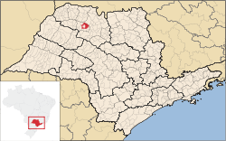 Location of Monte Aprazível | |
| Coordinates: 20°46′21″S 49°42′51″W | |
| Country | |
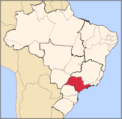
| Region | Southeast |
| State | |
| Mesoregion | São José do Rio Preto |
| Government | |
| • Mayor | Montoro |
| Area | |
| • Total | 496.9 km2 (191.9 sq mi) |
| Elevation | 475 m (1,558 ft) |
| Population (2010/IBGE) | |
| • Total | 21,746 |
| • Density | 43.76/km2 (113.3/sq mi) |
| Time zone | UTC-3 (UTC-3) |
| • Summer (DST) | UTC-2 (UTC-2) |
| Postal Code | 15150-000 |
| Area code(s) | +55 17 |
| 'HDI (UNDP/2000) | 0.808 – high |
| Website | Prefecture of Monte Aprazível |
Known as "The Dream's Dam City", because of a dam located nearby the city center.
Monte Aprazível belongs to the Mesoregion of São José do Rio Preto and is located 475 km from the city of São Paulo.
History
Monte Aprazível was founded by Captain Porfírio de Alcântara Pimentel, who was born in the city of Areias, São Paulo. In December 18, 1914, the district is created, and in December 23, 1924, the municipality is established with the emancipation from Rio Preto.[2]
Economy
The Tertiary sector and the Industry are the economic basis of Monte Aprazível. Commerce, services and public administration corresponds to 49% of the city GDP. The Secondary sector is 45.5% of the GDP, and the Primary sector corresponds to 5.5%.[3]
References
- "Population at "Censo 2010"" (PDF) (in Portuguese). IBGE.gov.br. Retrieved 14 Jul 2011.
- "History of the City". Monteaprazivel.sp.gov.br. Retrieved 15 July 2011.
- "Municipal Profile at SEADE". SEADE.gov.br. Archived from the original on 23 August 2011. Retrieved 15 July 2011.
Capital: São Paulo | |||||||||||||||||||||
|  | ||||||||||||||||||||
|
| |||||||||||||||||||||
| |||||||||||||||||||||
| |||||||||||||||||||||
| |||||||||||||||||||||
| |||||||||||||||||||||
| |||||||||||||||||||||
| |||||||||||||||||||||
| |||||||||||||||||||||
| |||||||||||||||||||||
| |||||||||||||||||||||
| |||||||||||||||||||||
| |||||||||||||||||||||
| |||||||||||||||||||||