Bom Sucesso de Itararé
Bom Sucesso de Itararé is a municipality in the Brazilian state of São Paulo. The population in 2010 was 3,571 and the area is 133.578 square kilometres (51.575 sq mi).[1][2] The elevation is 950 metres (3,120 ft).
Bom Sucesso de Itararé | |
|---|---|
 Flag  Coat of arms | |
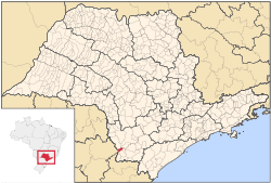 Location of Bom Sucesso de Itararé within the State of São Paulo | |
 Bom Sucesso de Itararé Location of Bom Sucesso de Itararé within Brazil | |
| Coordinates: 24°19′04″S 49°08′38″W | |
| Country | Brazil |
| State | São Paulo |
| Mesoregion | Itapetininga |
| Microregion | Itapeva |
| Government | |
| • Mayor | Dirceu Pacheco de Oliveira (2009–2012) (PSDB) |
| Area | |
| • Total | 133.578 km2 (51.575 sq mi) |
| Elevation | 950 m (3,120 ft) |
| Population (2010[1]) | |
| • Total | 3,571 |
| • Density | 27/km2 (69/sq mi) |
| Time zone | UTC-3 (BRT) |
| • Summer (DST) | UTC-2 (BRST) |
History
The municipality of Bom Sucesso de Itararé was established in 1991, when it was separated from Itararé.[3]
Government
- Mayor: Dirceu Pacheco de Oliveira (PSDB) (2009–2012)
Geography
Bom Sucesso de Itararé is located in the southern-subtropical part of Brazil, at 24 degrees, 19 minutes, 4 second south, and 49 degrees, 8 minutes, 38 seconds west, at an altitude of 950 metres (3,120 ft), in the internal part of the State of São Paulo. It covers an area of 133.578 square kilometres (51.575 sq mi).[2]
- Rivers
- Itararé River
- Verde River
- Pirituba River
Demography
Its population in 2010 was 3,571 inhabitants.[1]
- 2000 Census figures[4]
Total population: 3,231
- Urban: 1,954
- Rural: 1,277
- Men: 1,669
- Women: 1,562
Density (inhabitants/km2): 24.26
Infant mortality up to 1 year old (per thousand): 29.51
Life expectancy (years): 65.20
Fertility rate (children per woman): 3.40
Literacy rate: 85.82%
Human Development Index (HDI): 0.693
- Income: 0.603
- Longevity: 0.670
- Education: 0,805
Economy
The economy of Bom Sucesso de Itararé is based on ranching and mining industry. Its first mine was opened in 1949.
Transport
The first road linked Bom Sucesso to the municipality of Itararé A second riad was opened in 1948 and linked it to the city of Itapeva.
Education
Culture
Sports
Twin cities
References
- "Censo Populacional 2010" [Population Census 2010]. Censo Populacional 2010 (in Portuguese). IBGE. 29 November 2010. Archived from the original on 2011-05-16.
- IBGE (10 October 2002). "Área Territorial Brasileira – Consulta por Município – Resultados" [Brazilian Territorial Area - Browse by Municipality - Results] (in Portuguese).
- IBGE, history
- (Source: IPEADATA)