Capela do Alto
Capela do Alto is a municipality in the state of São Paulo in Brazil. It is part of the Metropolitan Region of Sorocaba.[1] The population is 19,482 (2015 est.) in an area of 169.89 km².[2] The elevation is 625 m.
Capela do Alto | |
|---|---|
 Coat of arms | |
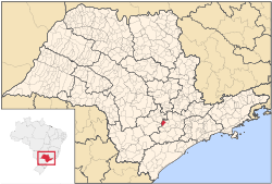 Location in São Paulo state | |
 Capela do Alto Location in Brazil | |
| Coordinates: 23°28′14″S 47°44′05″W | |
| Country | Brazil |
| Region | Southeast |
| State | São Paulo |
| Metrop. region | Sorocaba |
| Area | |
| • Total | 169.89 km2 (65.59 sq mi) |
| Elevation | 625 m (2,051 ft) |
| Population (2015) | |
| • Total | 19,482 |
| • Density | 110/km2 (300/sq mi) |
| Time zone | UTC-03:00 (BRT) |
| • Summer (DST) | UTC-02:00 (BRST) |
| Postal code | 18195 |
| Area code | +55 15 |
| Website | www |
Population history
| Historical population | ||
|---|---|---|
| Year | Pop. | ±% |
| 2001 | 14,247 | — |
| 2004 | 16,030 | +12.5% |
| 2015 | 19,482 | +21.5% |
Demographics
According to the 2000 IBGE Census, the population was 14,247, of which 11,111 are urban and 3,136 are rural. The average life expectancy was 69.31 years. The literacy rate was 89.43%.
References
- "Governo do Estado de São Paulo, Lei Complementar nº 1.241, de 8 de maio de 2014". Archived from the original on 2014-10-18. Retrieved 2015-09-29.
- Instituto Brasileiro de Geografia e Estatística
External links
- (in Portuguese) http://www.capeladoalto.sp.gov.br
- (in Portuguese) Capela do Alto on citybrazil.com.br
This article is issued from Wikipedia. The text is licensed under Creative Commons - Attribution - Sharealike. Additional terms may apply for the media files.