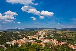
Cabreúva
Cabreúva is a municipality (município) in the state of São Paulo in Brazil. The population is 46,528 (2015 est.) in an area of 260.23 km².[1] The elevation is 640 m. The city takes its name from the Cabreúva tree (Myrocarpus frondosus), known as Kaburé-Iwa ("owl tree") in Tupi language.
Cabreúva | |
|---|---|
 | |
 Flag  Coat of arms | |
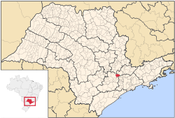 Location in São Paulo state | |
 Cabreúva Location in Brazil | |
| Coordinates: 23°18′27″S 47°7′59″W | |
| Country | Brazil |
| Region | Southeast |
| State | São Paulo |
| Microregion | Sorocaba |
| Area | |
| • Total | 260.23 km2 (100.48 sq mi) |
| Elevation | 640 m (2,100 ft) |
| Population (2015) | |
| • Total | 46,528 |
| • Density | 180/km2 (460/sq mi) |
| Time zone | UTC-03:00 (BRT) |
| • Summer (DST) | UTC-02:00 (BRST) |
| Postal code | 13315-xxx |
| Area code | +55-11 |
| Website | www |
History
The city was established in the beginning of 18th century by a member of the Martins e Ramos family, from the city of Itu, who followed the Tietê River to this place in a valley between the three mountains Japi, Guaxatuba and Taguá. Sugar cane was planted in the area for distilled beverage production, which earned the city its nickname Terra da Pinga.
Geography
The landscape is dominated by the mountains (Japi, Guaxatuba and Taguá) and the Tietê river. The altitudes vary between 640 m in the center of the city up to 1,200 m Serra do Japi. The area of the city is 260 km², of which 96 km² are urban and 165 km² are rural.
Population history
| Historical population | ||
|---|---|---|
| Year | Pop. | ±% |
| 2001 | 33,100 | — |
| 2004 | 36,106 | +9.1% |
| 2015 | 46,528 | +28.9% |
Demographics
According to the 2000 IBGE Census, the population was 33,100, of which 25,760 are urban and 7,340 are rural. The life expectancy was 71.14 years. The literacy rate was 90.05%.
Events
- March 24: Day of the municipal anniversary
External links
- (in Portuguese) SITE VISITE CABREUVA
- (in Portuguese) Homepage of Cabreúva
- (in Portuguese) Cabreúva on citybrazil.com.br
- (in Portuguese) Cabreúva's Newspaper - Caleidoscópio
- (in Portuguese) Cabreúva's Newspaper - Mais Cabreúva
- (in Portuguese) Cabreúva's Telephone directory
Places adjacent to Cabreúva | ||||||||||
|---|---|---|---|---|---|---|---|---|---|---|
| ||||||||||