Anhumas
Anhumas is a Brazilian municipality in the southern region of the state of São Paulo. Situated at 422 m above sea level, Anhumas is 500 km from the city of São Paulo. The population is 3,999 (2015 est.) in an area of 321 km².[1]
Anhumas | |
|---|---|
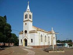 The Church of Santa Luzia in Anhumas | |
 Flag  Coat of arms | |
 Location in São Paulo state | |
 Anhumas Location in Brazil | |
| Coordinates: 22°17′44″S 51°23′15″W | |
| Country | Brazil |
| Region | Southeast |
| State | São Paulo |
| Area | |
| • Total | 321 km2 (124 sq mi) |
| Population (2015) | |
| • Total | 3,999 |
| • Density | 12/km2 (32/sq mi) |
| Time zone | UTC-03:00 (BRT) |
| • Summer (DST) | UTC-02:00 (BRST) |
History
The beginnings of the town can be traced back to 1875 when the Sorocabana Railroad opened up the region bounded by the Anhumas, Paranapanema, Peixe, and Aguapeí rivers. Initially, it was only a tiny village serving two farms which between them covered 30,000 acres. With the influx of immigrants, Anhumas had grown to 120 households by 1928 with 500 farmers working the surrounding land which was planted with 4,000,000 coffee trees. At that time, the town was under the governance of the municipality of Presidente Prudente.[2]
Until 1938, when the first wooden house was built, all the town's buildings were made from mudbricks, including its first chapel, which was built in 1921 and serviced by visiting priests. The town received its own parish and resident priest in 1936. The cornerstone for the parish church, dedicated to Santa Luzia, was laid in 1941. The church was completed in 1953, the same year in which Anhumas was granted status as an independent municipality.[2]
Geography and demography
Anhumas lies in the Mata Atlântica, a biome with a subtropical climate and characterised by moist broadleaf forests. The population of Anhumas had reached its height in 1950 when the town had 8,843 inhabitants. However its population fell over the ensuing years. By 1960 the population was 6,668; by 1980 it was 3,242. The estimated population in 2013 was 3,941. Its economy remains largely agriculture-based.[3]
References
- Instituto Brasileiro de Geografia e Estatística
- Anhumas.sp.gov.br. Histórico Archived 2014-05-18 at the Wayback Machine. Retrieved 19 May 2014 (in Portuguese).
- IBGE (Instituto Brasileiro de Geografia e Estatística). São Paulo » Anhumas. Retrieved 19 May 2014 (in Portuguese).
External links
- Official website (in Portuguese)