Auriflama
Auriflama is a municipality in the state of São Paulo, Brazil. The population is 14,961 (2015 est.) in an area of 434.3 km².[1] Auriflama belongs to the Mesoregion of São José do Rio Preto.
Auriflama | |
|---|---|
 Flag  Coat of arms | |
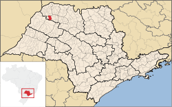 Location in São Paulo state | |
 Auriflama Location in Brazil | |
| Coordinates: 20°41′08″S 50°33′17″W | |
| Country | Brazil |
| Region | Southeast |
| State | São Paulo |
| Mesoregion | São José do Rio Preto |
| Microregion | Auriflama |
| Government | |
| • Mayor | Ivanilde Della Roveri Rodrigues |
| Area | |
| • Total | 434.3 km2 (167.7 sq mi) |
| Elevation | 595 m (1,952 ft) |
| Population (2015) | |
| • Total | 14,961 |
| • Density | 34/km2 (89/sq mi) |
| Time zone | UTC-03:00 (BRT) |
| • Summer (DST) | UTC-02:00 (BRST) |
| Postal code | 15350-000 |
| Area code | +55 17 |
| Website | www |
Economy
The Tertiary sector corresponds to 67.83% of Auriflama's GDP. The Primary sector is 9.68% of the GDP and the Industry corresponds to 22.49%.[2]
References
- Instituto Brasileiro de Geografia e Estatística
- "Municipal Profile at SEADE - Search". SEADE.gov.br. Archived from the original on 23 August 2011. Retrieved 28 July 2011.
This article is issued from Wikipedia. The text is licensed under Creative Commons - Attribution - Sharealike. Additional terms may apply for the media files.