Okutama, Tokyo
Okutama (奥多摩町, Oku-Tama-machi) is a town located in the western portion of Tokyo Metropolis, Japan. As of 1 February 2016, the town had an estimated population of 5,177, and a population density of 23 persons per km2. Its total area is 225.53 square kilometres (87.08 sq mi)[1].
Okutama 奥多摩町 | |
|---|---|
Town | |
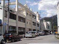 Okutama Town Hall | |
 Flag  Seal | |
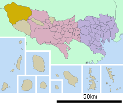 Location of Okutama in Tokyo | |
 Okutama | |
| Coordinates: 35°48′34.4″N 139°5′46.3″E | |
| Country | Japan |
| Region | Kantō |
| Prefecture | Tokyo |
| District | Nishitama |
| Area | |
| • Total | 225.53 km2 (87.08 sq mi) |
| Population (February 2016) | |
| • Total | 5,177 |
| • Density | 23/km2 (60/sq mi) |
| Time zone | UTC+9 (Japan Standard Time) |
| Symbols | |
| • Tree | Cryptomeria |
| • Flower | Azalea |
| • Bird | Copper pheasant |
| Phone number | 042-557-0501 |
| Address | 215-6 Hikawa, Okutama-machi, Nishitama-gun, Tokyo 198-0212 |
| Website | www |
Geography
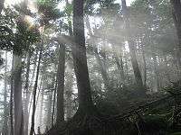
Okutama is located in the Okutama Mountains of far western Tokyo. It is geographically the largest municipality in Tokyo. Mount Kumotori, Tokyo's highest peak at 2017 m, divides Okutama from the Okuchichibu region of the neighboring Saitama and Yamanashi Prefectures. Tokyo's northernmost and westernmost points lie in Okutama, as does Lake Okutama, an important source of water for Tokyo, situated above the Ogōchi Dam in the town.[2]
Mountains
- Mount Kumotori
- Mount Kumotori, at 2017 m is the highest mountain in Tokyo and the westernmost place of Tokyo. Many plants grow here during the summer, most notably the tsuga. From the summit, there is a clear view of Mount Fuji and the Okuchichibu Mountains.[3]
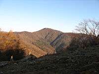
- Mount Mitō
- Because it was forbidden to enter Mount Mitō during the Edo period, there are still many forests of enormous beech trees. Mount Fuji and Mount Kumotori can be seen from the summit, and it attracts many visitors especially during autumn. It is one of the Three Mountains of Okutama.[4]
- Mount Ōdake
- Mount Ōdake is one of the Three Mountains of Okutama. From the summit at 1266 m, Mount Fuji can be seen to the south and Mount Gozen to the west.[5]
- Mount Kawanori
- From Mount Kawanori, all mountains in Okutama can be seen. Also, the Hyakuhiro Waterfall is located here.[6]
- Mount Gozen
- Mount Gozen is well known for its oddly perfectly triangular shape. Like Mount Mitō, it attracts visitors in the fall.
Rivers
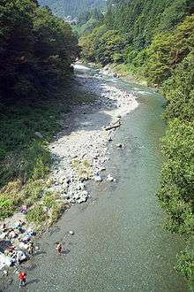
- Tama River
- The Tama River, with a length of 138 km, is the longest river in the prefecture. It flows through the entire prefecture, and the upstream of the river is located in Okutama.
- Hinohara River
- The Hinohara River is a rather short and small river located in the western portion of Tokyo.
Lakes
- Lake Okutama
- Lake Shiromaru
- Lake Shiromaru is a rather infamous dam on the Tama River. It has a height of 30.3 m, a length of 61 m, and a volume of 14,161 m3.
Surrounding municipalities
- Tokyo Metropolis
- Saitama Prefecture
- Yamanashi Prefecture
Climate
| Climate data for Lake Okutama (1981 - 2010) | |||||||||||||
|---|---|---|---|---|---|---|---|---|---|---|---|---|---|
| Month | Jan | Feb | Mar | Apr | May | Jun | Jul | Aug | Sep | Oct | Nov | Dec | Year |
| Record high °C (°F) | 17.8 (64.0) |
20.9 (69.6) |
22.5 (72.5) |
30.6 (87.1) |
33.0 (91.4) |
34.3 (93.7) |
35.8 (96.4) |
36.4 (97.5) |
35.0 (95.0) |
29.1 (84.4) |
23.8 (74.8) |
22.1 (71.8) |
36.4 (97.5) |
| Average high °C (°F) | 6.7 (44.1) |
7.1 (44.8) |
10.3 (50.5) |
16.3 (61.3) |
20.5 (68.9) |
23.0 (73.4) |
26.8 (80.2) |
28.2 (82.8) |
23.9 (75.0) |
18.4 (65.1) |
13.8 (56.8) |
9.3 (48.7) |
17.1 (62.8) |
| Daily mean °C (°F) | 1.3 (34.3) |
1.8 (35.2) |
5.0 (41.0) |
10.6 (51.1) |
15.1 (59.2) |
18.5 (65.3) |
22.0 (71.6) |
23.2 (73.8) |
19.5 (67.1) |
13.8 (56.8) |
8.5 (47.3) |
3.8 (38.8) |
11.9 (53.4) |
| Average low °C (°F) | −2.7 (27.1) |
−2.3 (27.9) |
0.6 (33.1) |
5.6 (42.1) |
10.5 (50.9) |
14.8 (58.6) |
18.7 (65.7) |
19.7 (67.5) |
16.3 (61.3) |
10.3 (50.5) |
4.6 (40.3) |
−0.1 (31.8) |
8.19 (46.74) |
| Record low °C (°F) | −9.3 (15.3) |
−11.6 (11.1) |
−8.1 (17.4) |
−3.8 (25.2) |
0.7 (33.3) |
8.8 (47.8) |
12.4 (54.3) |
14.2 (57.6) |
6.2 (43.2) |
1.0 (33.8) |
−2.1 (28.2) |
−6.2 (20.8) |
−11.6 (11.1) |
| Average precipitation mm (inches) | 44.1 (1.74) |
50.0 (1.97) |
92.5 (3.64) |
109.6 (4.31) |
120.3 (4.74) |
155.7 (6.13) |
195.4 (7.69) |
280.6 (11.05) |
271.3 (10.68) |
172.4 (6.79) |
76.7 (3.02) |
39.9 (1.57) |
1,623.5 (63.92) |
| Average precipitation days (≥ 1.0 mm) | 4.8 | 5.9 | 10.6 | 10.2 | 11.2 | 13.8 | 15.4 | 12.5 | 13.9 | 10.6 | 6.9 | 4.0 | 119.8 |
| Mean monthly sunshine hours | 147.1 | 127.7 | 132.2 | 161.8 | 154.9 | 109.8 | 127.6 | 148.3 | 99.1 | 94.5 | 122.1 | 145.6 | 1,570.7 |
| Source 1: 気象庁 | |||||||||||||
| Source 2: 観測史上1〜10位の値(年間を通じての値) | |||||||||||||
History
Prehistory
People began settling in Okutama from before the Jōmon Period and many archaeological sites have been found with ancient pottery. During the Yayoi period, rice cultivation began in the flatter lands of present-day Okutama, but most of the area remained covered by forests and only small flat lands existed.[7]
Premodern period
During the Edo period, the area included in present-day Okutama was divided into 16 villages within Musashi Province. In each village, there was one person who served as the mayor, another who served as the leader of a particular group, and another who served as a representative for the farmers. Also, entering Mount Takanosu was forbidden for people of low rank during this time. This was because the people of high rank (government officials and such) hunted with hawks at the mountain, and the officials wanted to keep the hunting grounds for themselves.[7]
Modern Times
With the start of the Meiji period, the area of Okutama became part of Nirayama Prefecture except for Kotaba village, which was merged into Maebashi Domain, which then became part of Gunma Prefecture. While Kotaba village was turned into part of Maebashi city, the Okutama area was divided into three villages of Hikawa, Kori, and Ogouchi with the establishment of the municipalities system on April 1, 1889. In 1940, Hikawa was elevated to town status. In 1955, Hikawa town, Ogouchi village and Kori village were united, forming the town of Okutama.[7]
Economy
Seasonal tourism, forestry and charcoal production are mainstays of the local economy.
Education
Okutama has two elementary and two middle schools. The town does not have a high school.
Transportation
Railway
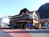
The East Japan Railway Company serves the town. The Ōme line, which connects the town with Tachikawa, terminates at Okutama Station.
Bus
The Nishi Tokyo Bus Co. carries passengers to Lake Okutama, the Nippara Limestone Cave, Tabayama village and Kosuge village (both in Yamanashi Prefecture) from Oku-Tama Station.
Highway
- National Highways
- Prefectural Roads
- Tokyo Prefectural Road 184 Okutama-Akiruno
- Tokyo Prefectural Road 204 Nippara Limestone Cave
- Tokyo Prefectural Road 205
- Tokyo Prefectural Road 206 Kawano-Kamikawa
Local attractions
All of the town is located in Chichibu-Tama-Kai National Park.
- Lake Okutama
- Lake Okutama plays a major role in providing drinking water for the people of Tokyo. The largest lake in Tokyo, it also has a large dam.[8]
- Mount Takanosu
- During the Edo Period, the people of low rank were forbidden to enter Mount Takanosu, because it was a hawk hunting ground for the government and military officials. Now, it is open to hikers, and has an elevation of 1736.6 m.
- Tsurunoyu Onsen
- Until the construction of Ogouchi Dam, there was a spa town for Tsurunoyu Onsen. (It is now in the depths of the dam.) Now, there are a few inns that use the hot water from the hot spring for their spas. The hot spring is located about 20 minutes by bus from Oku-Tama Station.
- Hyakuhiro Waterfall
- Hyakuhiro Waterfall, with a height of 40 m, is a famous waterfall in the Okutama area. Located in Mount Kawanori, it is part of the Nippara River.
- Nippara Cave
- Nippara Cave is the second largest limestone cave in the Kantō region after the Fujido Cave in Gunma Prefecture, and attracts many visitors from around Japan.[9]
- Okuchichibu Mountains
- The Okuchichibu Mountains stretch from Nagano's Nobeyama region to Okutama and a portion of Saitama Prefecture and Yamanashi Prefecture. The highest mountain is Mount Kurogane (Yamanashi Prefecture), at 2232 m, and the lowest is Mount Azumaya (Saitama Prefecture), at 772 m.
- Okutama Onsen
- Okutama Onsen is a hot spring located in the town.
References
- 東京都奥多摩町ホームページ
- 考える社会科地図 Kangaeru Shakaika Chizu. 四谷大塚出版 Yotsuya-Ōtsuka Shuppan. 2005. p. 113.
- 奥多摩町観光案内-奥多摩トレッキングコース-雲取山
- 奥多摩町観光案内-奥多摩トレッキングコース-御前山・三頭山 Archived 2007-11-15 at the Wayback Machine
- 奥多摩町観光案内-奥多摩トレッキングコース-大岳山・御岳山
- 奥多摩町観光案内-奥多摩トレッキングコース-川苔山
- Introduction to Okutama Archived 2007-08-24 at the Wayback Machine
- 楽しく学ぶ小学生の地図帳 Tanoshiku Manabu Shogakusei no Chizucho. 帝国書院 Teikoku-Shoin. 2004. p. 37.
- http://ridgelineimages.com/sightseeing/10-lesser-known-places-visit-near-tokyo/
External links

- Okutama Town Official Website (in Japanese)
| Wikivoyage has a travel guide for Okutama. |
| |||||||
| Special Wards of Tokyo | |||||||
| Western (Tama area) |
| ||||||
| Subprefectures | |||||||
| |||||||
| Authority control |
|
|---|