Niijima, Tokyo
Niijima (新島村, Niijima-mura) is a village located in Ōshima Subprefecture, Tokyo Metropolis, Japan. As of 1 June 2016, the village had an estimated population of 2,697, and a population density of 97.9 persons per km². Its total area is 27.54 square kilometres (10.63 sq mi).
Niijima 新島村 | |
|---|---|
Village | |
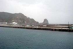 Port of Niijima | |
 Flag  Seal | |
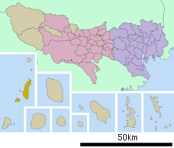 Location of Niijima in Tokyo Metropolis | |
 Niijima | |
| Coordinates: 34°22′37.4″N 139°15′24.3″E | |
| Country | Japan |
| Region | Kantō |
| Prefecture | Tokyo Metropolis |
| Area | |
| • Total | 27.54 km2 (10.63 sq mi) |
| Population (June 2016) | |
| • Total | 2,697 |
| • Density | 97.9/km2 (254/sq mi) |
| Time zone | UTC+9 (Japan Standard Time) |
| Phone number | 04992-5-0240 |
| Address | 1-1-1, Honson, Niijima-mura, Tōkyō-to 100-0402 |
| Website | www |
Geography
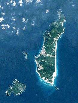
The village of Niijima consists of the inhabited islands of Nii-jima and Shikinejima, the uninhabited islands of Udoneshima and Jinai-tō, and numerous small rocks in the northern Izu archipelago.
Surrounding Municipalities
- Tokyo Metropolis
History
On October 1, 1923, the islands of Niijima and Shikinejima were organized into municipalities. Niijima was administered as Niijimahon (新島本村, Niijima-honson, lit. "Niijima Main Village"). Shikenejima was administered as Wakagō (若郷村, Wakagō-mura). Both villages belonged to Ōshima Island Government Office. In 1926, the Ōshima Island Government Office became Ōshima Subprefecture of Tokyo. On November 1, 1954, Niijimahon absorbed the village of Wakagō, and changed its name to Niijima Village on April 1, 1992.
Economy
The economy of the village is dependent on commercial fishing and seasonal tourism. The village is known for its sports fishing, hot spring resorts) and local beer.
Transportation
- Airports
- Niijima Airport at Niijima
- Airlines
- New Central Airlines operates the route between Niijima and Chōfu Airport 4 laps a day. Single trip takes 40 minutes.
- Roads
- National highways: None
- Metropolitan highways:
- 211 Wakagō Niijima-kō Line
- 237 Shikinejima Circle Line
- Ports
- Niijima: Port of Niijima
- Shikinejima: Port of Nobushi, Fishing Port of Nobushi, Port of Shikinejima, Fishing Port of Ashitsuki, Fishing Port of Kobama
- Sea routes
- Between Niijima and Nobushi
- Camellia-maru by Tōkai Kisen links between Tokyo, Yokohama (on Friday and Saturday), Izu Ōshima, Toshima, and Niijima.
- Jinshin Kisen links between Shimoda, Toshima, Niijima, Shikinejima, Kōzushima, and Shimoda. A ship runs this direction on Sunday, Tuesday, and Friday. It goes backwards on Monday, Thursday, and Saturday.
- Nishiki 2 by Niijima Village links between Niijima and Shikinejima 3 laps a day.
- Cargo ships by Niijima Bussan and Izu Shichitō Kaiun links between the islands and mainland Tokyo.
Education
- High schools
- Tokyo Metropolitan Niijima High School
- Junior High Schools
- Niijima Junior High School
- Shikinejima Junior High School
- Elementary Schools
- Niijima Elementary School
- Shikinejima Elementary School
References
External links
| Wikimedia Commons has media related to Niijima, Tokyo. |
| Wikivoyage has a travel guide for Niijima. |
- Niijima Village Official Website (in Japanese)
| |||||||
| Special Wards of Tokyo | |||||||
| Western (Tama area) |
| ||||||
| Subprefectures | |||||||
| |||||||