List of waterfalls in Yellowstone National Park
Yellowstone National Park contains at least 45 named waterfalls and cascades, and hundreds more unnamed, even undiscovered waterfalls over 15 feet (4.6 m) high. The highest plunge type waterfall in the park is the lower Falls of Yellowstone Falls at 308 feet (94 m). The highest horsetail type is Silver Cord Cascade at 1,200 feet (370 m).

Lower Yellowstone Falls
Northwest quadrant[1]
- Firehole Falls, 40 feet (12 m), Firehole River, 44°37′51″N 110°51′52″W[2]
- Gibbon Falls, 84 feet (26 m), Gibbon River, 44°39′16″N 110°46′15″W[3]
- Hidden Falls, 20 feet (6.1 m), Blacktail Deer Creek
- Little Gibbon Falls, 25 feet (7.6 m), Gibbon River
- Osprey Falls, 150 feet (46 m), Gardner River, 44°55′42″N 110°40′53″W[4]
- Undine Falls, Lava Creek, 44°56′39″N 110°38′20″W[5]
 Undine Falls
- Upper 60 feet (18 m)
- Lower 38 feet (12 m)
- Rustic Falls, 47 feet (14 m), Glen Creek, 44°56′03″N 110°43′33″W[6]
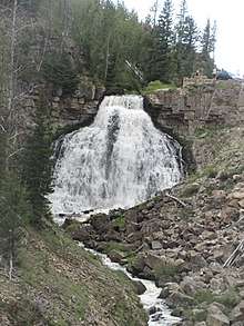 Rustic Falls
 - Silver Cascades, 80 feet (24 m), Stephans Creek
- Virginia Cascades, 60 feet (18 m), Gibbon River, 44°42′47″N 110°38′46″W[7]
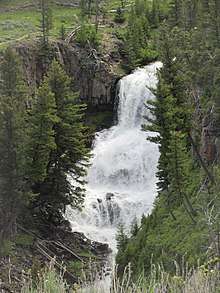
- Wraith Falls, 100 feet (30 m), Lava Creek, 44°56′14″N 110°37′25″W[8]
 Wraith Falls
Northeast quadrant[9]
- Birdseye Falls
- Citadel of Asgard Falls, 150 feet (46 m), Mystery Creek
- Crystal Falls, 129 feet (39 m), Cascade Creek, 44°43′05″N 110°30′03″W[10]
- Enchantress Falls, 90 feet (27 m), Beauty Creek
- Faires' Fall, Amethyst Creek
- Knowles Falls, 15 feet (4.6 m), Yellowstone River, 45°00′42″N 110°35′41″W[11]
- Silver Cord Cascade, 1,200 feet (370 m), Surface Creek, 44°43′34″N 110°27′06″W[12]
- Tower Fall, 132 feet (40 m), Tower Creek
- Yellowstone Falls, Yellowstone River
- Upper Falls, 109 feet (33 m), 44°42′46″N 110°29′58″W[13]
- Lower Falls, 308 feet (94 m), 44°43′05″N 110°29′46″W[14]
Southwest quadrant[15]
- Albright Falls, 260 feet (79 m), Bechler River, 44°16′40″N 110°54′13″W[16]
- Cave Falls, 20 feet (6.1 m), Fall River, 44°08′41″N 110°59′50″W[17]
- Bechler Falls, 15 feet (4.6 m), Bechler River, 44°08′57″N 111°00′36″W[18]
- Cascades of the Firehole, 40 feet (12 m), Firehole River, 44°36′59″N 110°51′20″W[19]
- Chasm Falls, Ouzel Creek
- Childhood's Dream Falls, 30 feet (9.1 m), Ouzel Creek
- Colonnade Falls, Bechler River, 44°14′19″N 110°56′53″W[20]
- Upper 35 feet (11 m)
- Lower 67 feet (20 m)
- Dunanda Falls, 150 feet (46 m), Boundary Creek, 44°14′52″N 111°01′27″W[21]
- Emerald Pool Falls, Ouzel Creek
- Fairy Falls, 197 feet (60 m), Fairy Creek, 44°31′28″N 110°52′16″W[22]
- Fern Cascades, 50 feet (15 m), Iron Spring Creek, 44°26′46″N 110°50′39″W[23]
- Gwinna Falls, 15 feet (4.6 m), Bechler River, 44°16′55″N 110°52′49″W[24]
- Hourglass Falls (see Quiver Cascade)
- Iris Falls, 45 feet (14 m), Bechler River, 44°14′30″N 110°56′37″W[25]
- Kepler Cascades, 150 feet (46 m), Firehole River,44°26′45″N 110°48′26″W[26]
- Lewis Canyon Falls, Lewis River
- Upper Falls, 80 feet (24 m)
- Lower Falls, 50 feet (15 m)
- Lewis Falls, 30 feet (9.1 m), Lewis River, 44°16′02″N 110°38′15″W[27]
- Lily Falls, 15 feet (4.6 m), Unnamed Creek, 44°12′58.80″N 110°39′25.17″W[28]
- Moose Falls, 30 feet (9.1 m), Crawfish Creek, 44°09′08″N 110°40′20″W[29]
- Morning Falls, Ash Mountain Creek
- Mystic Falls, 70 feet (21 m), Little Firehole River, 44°29′03″N 110°52′26″W[30]
- Ouzel Falls, 230 feet (70 m), Ouzel Creek, 44°14′06″N 110°58′33″W[31]
- Quiver Cascade, 98 feet (30 m), Bechler River, 44°18′18″N 110°52′53″W[32]
- Ragged Falls, 45 feet (14 m), Bechler River, 44°17′17″N 110°53′24″W[33]
- Rainbow Falls, 55 feet (17 m), Fall River
- Silver Scarf Falls, 250 feet (76 m), East Fork Boundary Creek, 44°08′50″N 110°51′51″W
- Tempe Cascade, 30 feet (9.1 m), Bechler River, 44°14′48.65″N 111°1′16.73″W[34]
- Terraced Falls, 130 feet (40 m), Fall River, 44°08′50″N 110°51′51″W[35]
- Tendoy Falls, 33 feet (10 m), Bechler River, Ferris Fork, 44°08′50″N 110°51′51″W
- "Treasure Falls", "Lilliputian Creek" (Treasure Island of the Bechler River)
- Twister Falls, 55 feet (17 m), Bechler River, 44°17′52″N 110°52′43″W
- Union Falls, 250 feet (76 m), Mountain Ash Creek, 44°11′34″N 110°52′15″W[36]
- Wahhi Falls, Bechler River, 44°16′31″N 110°52′40″W[37]
- Upper 28 feet (8.5 m)
- Lower 18 feet (5.5 m)
Southeast quadrant[38]
- Crecelius Cascade, 75 feet (23 m), Eleanor Lake
Further reading
- Barber, John F. (1984). Ribbons of water : the waterfalls and cascades of Yellowstone National Park. ISBN 0-934948-05-4.
- Whittlesey, Lee (1988). Yellowstone Place Names. Helena, MT: Montana Historical Society Press. ISBN 0-917298-15-2.
- Maynard, Charles (1996). Waterfalls of Yellowstone National Park. Panther Press. ISBN 1-887205-06-3.
- Rubenstein, Paul (2000). The guide to Yellowstone waterfalls and their discovery. ISBN 1-56579-351-X.
Notes
- Trails Illustrated-Mammoth Hot Springs, Yellowstone National Park (303) (Map) (Revised ed.). 1:63360. National Geographic Maps. 2008. ISBN 1-56695-304-9.
- "Firehole Falls". Geographic Names Information System. United States Geological Survey.
- "Gibbon Falls". Geographic Names Information System. United States Geological Survey.
- "Osprey Falls". Geographic Names Information System. United States Geological Survey.
- "Undine Falls". Geographic Names Information System. United States Geological Survey.
- "Rustic Falls". Geographic Names Information System. United States Geological Survey.
- "Virginia Cascades". Geographic Names Information System. United States Geological Survey.
- "Wraith Falls". Geographic Names Information System. United States Geological Survey.
- Trails Illustrated-Tower/Canyon, Yellowstone National Park (304) (Map) (Revised ed.). 1:63360. National Geographic Maps. 2008. ISBN 1-56695-435-5.
- "Crystal Falls". Geographic Names Information System. United States Geological Survey.
- "Knowles Falls". Geographic Names Information System. United States Geological Survey.
- "Silver Cord Cascade". Geographic Names Information System. United States Geological Survey.
- "Upper Yellowstone Falls". Geographic Names Information System. United States Geological Survey.
- "Lower Yellowstone Falls". Geographic Names Information System. United States Geological Survey.
- Trails Illustrated-Old Faithful, Yellowstone National Park (302) (Map) (Revised ed.). 1:63360. National Geographic Maps. 2008. ISBN 1-56695-433-9.
- "Albright Falls". Geographic Names Information System. United States Geological Survey.
- "Cave Falls". Geographic Names Information System. United States Geological Survey.
- "Bechler River". Geographic Names Information System. United States Geological Survey.
- "Cascades of the Firehole". Geographic Names Information System. United States Geological Survey.
- "Colonnade Falls". Geographic Names Information System. United States Geological Survey.
- "Dunanda Falls". Geographic Names Information System. United States Geological Survey.
- "Fairy Falls". Geographic Names Information System. United States Geological Survey.
- "Fern Cascades". Geographic Names Information System. United States Geological Survey.
- "Gwinna Falls". Geographic Names Information System. United States Geological Survey.
- "Iris Falls". Geographic Names Information System. United States Geological Survey.
- "Kepler Cascades". Geographic Names Information System. United States Geological Survey.
- "Lewis Falls". Geographic Names Information System. United States Geological Survey.
- "Lily Falls". Geographic Names Information System. United States Geological Survey.
- "Moose Falls". Geographic Names Information System. United States Geological Survey.
- "Mystic Falls". Geographic Names Information System. United States Geological Survey.
- "Ouzel Falls". Geographic Names Information System. United States Geological Survey.
- "Quiver Cascade". Geographic Names Information System. United States Geological Survey.
- "Ragged Falls". Geographic Names Information System. United States Geological Survey.
- "Tempe Cascade". Geographic Names Information System. United States Geological Survey.
- "Terraced Falls". Geographic Names Information System. United States Geological Survey.
- "Union Falls". Geographic Names Information System. United States Geological Survey.
- "Wahhi Falls". Geographic Names Information System. United States Geological Survey.
- Trails Illustrated-Yellowstone Lake, Yellowstone National Park (305) (Map) (Revised ed.). 1:63360. National Geographic Maps. 2003. ISBN 1-56695-361-8.
Boise (capital) | ||
| Topics |
|  Seal of Idaho |
| Society | ||
| Regions | ||
| Larger cities | ||
| Smaller cities | ||
| Counties |
| |

This article is issued from Wikipedia. The text is licensed under Creative Commons - Attribution - Sharealike. Additional terms may apply for the media files.