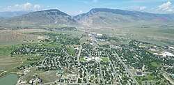
Cody, Wyoming
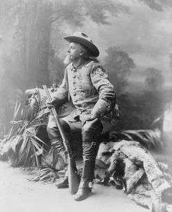
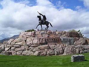
Cody is a city in Northwest Wyoming and the county seat of Park County, Wyoming, United States.[6] It is named after Colonel William Frederick "Buffalo Bill" Cody for his part in the founding of Cody in 1896.[7]
Cody, Wyoming | |
|---|---|
 | |
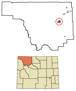 Location of Cody in Park County, Wyoming. | |
| Coordinates: 44°31′24″N 109°3′26″W | |
| Country | |
| State | |
| County | |
| Named for | William Frederick Cody |
| Government | |
| • Mayor | Matt Hall |
| Area | |
| • Total | 10.46 sq mi (27.08 km2) |
| • Land | 10.22 sq mi (26.47 km2) |
| • Water | 0.24 sq mi (0.61 km2) |
| Elevation | 5,016 ft (1,523 m) |
| Population | |
| • Total | 9,520 |
| • Estimate (2018)[3] | 9,828 |
| • Density | 961.64/sq mi (371.30/km2) |
| Time zone | UTC−7 (Mountain (MST)) |
| • Summer (DST) | UTC−6 (MDT) |
| ZIP code | 82414 |
| Area code(s) | 307 Exchanges: 527,578,587 |
| FIPS code | 56-15760[4] |
| GNIS feature ID | 1586861[5] |
| Website | https://www.cityofcody-wy.gov |
The population was 9,520 at the 2010 census. Cody is served by Yellowstone Regional Airport.
Geography
Cody is located at 44°31′24″N 109°3′26″W (44.523244, −109.057109).[8]
According to the United States Census Bureau, the city has a total area of 10.43 square miles (27.01 km2), of which, 10.20 square miles (26.42 km2) is land and 0.23 square miles (0.60 km2) is water.[9]
Cody's elevation is about 5016 ft (1,500 m) above sea level. The main part of the city is split across three levels, separated by about 60 feet (18 m).
The Shoshone River flows through Cody in a fairly deep canyon. There are four bridges over this river in the Cody vicinity, one at the north edge of town that allows travel to the north, and one about 5 miles (8.0 km) east of Cody that allows passage to Powell and the areas to the north and east. The other two are west of town; one allows access to the East Gate of Yellowstone National Park, and the other is used by fishermen in Shoshone Canyon and as access to the Buffalo Bill Dam.
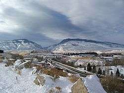
Cody is located at the western edge of the Bighorn Basin, a depression surrounded by the Big Horn, Owl Creek, Bridger, and Absaroka ranges. At the western edge of Cody, a deep canyon formed by the Shoshone River provides the only passage to Yellowstone's Eastern Entrance. At its mouth and rising above Cody are Rattlesnake Mountain on the north side and Cedar Mountain on the south side. Much of Cody has views of Heart Mountain, whose 8,123 ft (2,500 m) peak is 9 miles (14 km) directly north of Cody, and the Carter Mountain massif, which forms a line with peaks above 12,000 ft (3,700 m), some 15 miles (24 km) to the south.
Climate
Cody experiences a semi-arid climate (Köppen BSk), with highly variable conditions. Relative humidity is usually a fairly dry 30% or less. Precipitation averages 10.5 inches or 266.7 millimetres annually, including 42.5 inches or 1.08 metres of snow per season. Due to the aridity, snow cover is highly unreliable, with 27 days per season with 1 inch or 0.025 metres or more on the ground. Cody enjoys about 300 days of sunshine per year.
Wind is almost a constant presence in the Cody area and the Big Horn Basin in general. Air flow in the Basin is turbulent, but during the winter most storms move in from the north-northwest. During the summer, it is not unusual to see storms move in from the southwest. Throughout a normal day, winds can be experienced as coming from almost any direction, mostly from the north and west, but sometimes from the south and east. The Canyon at the west end of Cody funnels rain and wind across the city from the west. The winds can be quite strong at 30 to 40 miles per hour (48 to 64 km/h) and last for several days.
Because of the dry climate, the entire area is laced with irrigation canals, holding ponds, laterals, and drops. The Buffalo Bill Dam between Rattlesnake and Cedar mountains forms a large reservoir about 10 miles (16 km) to the west of Cody. This reservoir (among others) feeds the Shoshone Project, a large irrigation water distribution system.
The monthly daily average temperature ranges from 25.9 °F or −3.4 °C in December to 69.9 °F or 21.1 °C in July. An average of 13.8 days have highs of 90 °F (32 °C) or higher and an average of 13.2 days have lows of 0 °F (−18 °C) or lower; the average window for freezing temperatures is September 27 thru May 14 and for measurable (≥0.1 inches or 0.25 centimetres snow, October 24 thru April 17. The record high temperature was 105 °F or 40.6 °C on July 14, 1925, and the record low temperature was −46 °F or −43.3 °C on February 8, 1936.
The wettest calendar year has been 1991 with 16.04 inches (407.4 mm) and the driest 1956 with 3.58 inches (90.9 mm). The most rainfall in one month was 5.76 in (146 mm) in June 1992. The most rainfall in 24 hours was 2.51 inches or 64 millimetres on July 22, 1973. There are an average of 70 days with measurable precipitation. The most snow in one year was 73.4 inches (1.86 m) between July 1916 and June 1917. The most snow in one month was 26.3 inches (0.67 m) in January 1972.[10]
| Climate data for Cody, Wyoming (1981–2010 normals) | |||||||||||||
|---|---|---|---|---|---|---|---|---|---|---|---|---|---|
| Month | Jan | Feb | Mar | Apr | May | Jun | Jul | Aug | Sep | Oct | Nov | Dec | Year |
| Record high °F (°C) | 68 (20) |
75 (24) |
79 (26) |
87 (31) |
94 (34) |
103 (39) |
105 (41) |
103 (39) |
97 (36) |
87 (31) |
74 (23) |
67 (19) |
105 (41) |
| Average high °F (°C) | 37.4 (3.0) |
40.3 (4.6) |
49.1 (9.5) |
57.2 (14.0) |
66.1 (18.9) |
75.2 (24.0) |
83.8 (28.8) |
82.3 (27.9) |
72.1 (22.3) |
59.5 (15.3) |
45.2 (7.3) |
36.0 (2.2) |
58.7 (14.8) |
| Average low °F (°C) | 16.4 (−8.7) |
18.2 (−7.7) |
25.9 (−3.4) |
32.8 (0.4) |
41.3 (5.2) |
49.2 (9.6) |
56.1 (13.4) |
54.5 (12.5) |
45.6 (7.6) |
35.3 (1.8) |
24.9 (−3.9) |
15.8 (−9.0) |
34.7 (1.5) |
| Record low °F (°C) | −40 (−40) |
−46 (−43) |
−23 (−31) |
−18 (−28) |
15 (−9) |
25 (−4) |
33 (1) |
29 (−2) |
9 (−13) |
−11 (−24) |
−24 (−31) |
−35 (−37) |
−46 (−43) |
| Average precipitation inches (mm) | .32 (8.1) |
.33 (8.4) |
.56 (14) |
1.10 (28) |
1.77 (45) |
1.68 (43) |
1.15 (29) |
.91 (23) |
1.06 (27) |
.86 (22) |
.46 (12) |
.29 (7.4) |
10.49 (266.9) |
| Average snowfall inches (cm) | 6.7 (17) |
6.1 (15) |
6.4 (16) |
5.1 (13) |
.7 (1.8) |
0 (0) |
0 (0) |
0 (0) |
.2 (0.51) |
4.1 (10) |
5.9 (15) |
7.3 (19) |
42.5 (107.31) |
| Average precipitation days (≥ 0.01 in) | 2.8 | 2.9 | 5.3 | 7.5 | 9.6 | 9.3 | 7.3 | 6.9 | 6.5 | 5.0 | 3.7 | 3.4 | 70.1 |
| Average snowy days (≥ 0.1 in) | 2.6 | 2.3 | 2.7 | 1.8 | .2 | 0 | 0 | 0 | .1 | 1.3 | 2.2 | 3.1 | 16.5 |
| Source: NOAA (extremes 1915–present)[11] | |||||||||||||
Culture
Themes surrounding Cody's pioneer and Cowboy and Western history are common in the cultural events and activities in the area.
The Buffalo Bill Center of the West, is a large and modern facility located near the center of the city. It contains five museums in one, including the Draper Natural History Museum, the Plains Indian Museum, the Cody Firearms Museum, the Whitney Western Art Museum and the Buffalo Bill Museum which chronicles the life of William F. Cody, for whom the historical center is named. The historical center maintains large collections. It is a favorite stopping point for tourists passing through the town, on their way to or from Yellowstone.
Old Trail Town, a restoration of more than twenty-five historic Western buildings and artifacts is located in Cody just off the Yellowstone Highway.
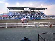
Rodeo is important in the culture in Cody, which calls itself the "Rodeo Capital of the World". The Cody Nite Rodeo is an amateur rodeo every night from June 1 through August 31.
Cody is also host to the Cody Stampede Rodeo. The Stampede is a Professional Rodeo Cowboys Association rodeo and is one of the largest rodeos in the nation that is held over the Independence Day Holiday. Many of the top cowboys in the country attend. The stampede has been held from July 1–4 every year since 1919. Cody hosts the Cody Stampede, a weeklong series of events around the 4th of July, featuring several parades where the main street is blocked off, rodeos, fireworks and more. In 2019 Cody Stampede celebrated their 100th year.[12]
The Heart Mountain Relocation Center, where thirteen thousand Japanese Americans were interned during World War II, is approximately seventeen miles east of town. The site includes surviving buildings from the camp and a visitor's center.
Grammy-Winning rapper Kanye West purchased a 4000-acre ranch in 2019.[13]
Education
Public education in the city of Cody is provided by Park County School District#6. Three elementary schools – Eastside, Glenn Livingston, and Sunset - serve students in grades kindergarten through five. The district's two secondary campuses are Cody Middle School (grades 6-8) and Cody High School (grades 9-12).
Cody has a public library, a branch of the Park County Library System.[14]
Industry
The primary industry in Cody is tourism. Hotels, restaurants and shops cater to travelers coming to visit the West and Yellowstone Park. Cody has several art galleries, with some notable local painters and artists living in the area.
Cody is fast becoming a hub for Outdoor Recreation. The Shoshone River runs through town offering Class I-V kayaking and whitewater rafting. Shoshone Canyon offers over 300 rock climbing routes, while Cedar Mountain boasts nearly 600 boulder problems. Cody hosts nearly 50 miles of single track, with a large amount of it accessible by bike from town. A bike park was recently completed with Jump and Drop lines as well as a Pump track.
Another industry is western style furniture, with several small furniture makers producing custom pieces.
The oil industry seems to wax and wane over the years in the Cody area.
Just to the south of Cody are large deposits of gypsum.
Park County School District#6 is another large employer in the area.
Cody is set to be the new headquarters for Kanye West's Yeezy brand as of 2019.[15]
Demographics
| Historical population | |||
|---|---|---|---|
| Census | Pop. | %± | |
| 1910 | 1,132 | — | |
| 1920 | 1,242 | 9.7% | |
| 1930 | 1,800 | 44.9% | |
| 1940 | 2,536 | 40.9% | |
| 1950 | 3,872 | 52.7% | |
| 1960 | 4,838 | 24.9% | |
| 1970 | 5,161 | 6.7% | |
| 1980 | 6,599 | 27.9% | |
| 1990 | 7,897 | 19.7% | |
| 2000 | 8,835 | 11.9% | |
| 2010 | 9,520 | 7.8% | |
| Est. 2018 | 9,828 | [3] | 3.2% |
| [16] | |||
2010 census
As of the census[2] of 2010, there were 9,520 people, 4,278 households, and 2,502 families living in the city. The population density was 933.3 inhabitants per square mile (360.3/km2). There were 4,650 housing units at an average density of 455.9 per square mile (176.0/km2). The racial makeup of the city was 95.9% White, 0.2% African American, 0.7% Native American, 0.4% Asian, 0.1% Pacific Islander, 1.0% from other races, and 1.8% from two or more races. Hispanic or Latino of any race were 3.1% of the population.
There were 4,278 households, of which 26.5% had children under the age of 18 living with them, 45.0% were married couples living together, 9.5% had a female householder with no husband present, 4.0% had a male householder with no wife present, and 41.5% were non-families. 34.8% of all households were made up of individuals, and 13.2% had someone living alone who was 65 years of age or older. The average household size was 2.19 and the average family size was 2.82.
The median age in the city was 42.4 years. 21.8% of residents were under the age of 18; 7.1% were between the ages of 18 and 24; 24.1% were from 25 to 44; 28.9% were from 45 to 64; and 18.2% were 65 years of age or older. The gender makeup of the city was 48.2% male and 51.8% female.
2000 census
As of the census[4] of 2000, there were 8,835 people, 3,791 households, and 2,403 families living in the city. The population density was 952.3 people per square mile (367.6/km2). There were 4,113 housing units at an average density of 443.3 per square mile (171.1/km2). The racial makeup of the city was 96.90% White, 0.10% African American, 0.42% Native American, 0.58% Asian, 0.05% Pacific Islander, 0.85% from other races, and 1.11% from two or more races. Hispanic or Latino of any race were 2.22% of the population.
There were 3,791 households, out of which 29.0% had children under the age of 18 living with them, 50.7% were married couples living together, 9.5% had a female householder with no husband present, and 36.6% were non-families. 32.2% of all households were made up of individuals, and 12.4% had someone living alone who was 65 years of age or older. The average household size was 2.27 and the average family size was 2.86.
In the city, the population was spread out, with 24.8% under the age of 18, 7.2% from 18 to 24, 26.4% from 25 to 44, 24.9% from 45 to 64, and 16.6% who were 65 years of age or older. The median age was 40 years. For every 100 females, there were 90.9 males. For every 100 females age 18 and over, there were 88.1 males.
The median income for a household in the city was $34,450, and the median income for a family was $40,554. Males had a median income of $31,395 versus $19,947 for females. The per capita income for the city was $17,813. About 9.4% of families and 13.9% of the population were below the poverty line, including 19.3% of those under age 18 and 11.0% of those age 65 or over.
Government
Cody is governed via a city council and mayor. The mayor is elected in a citywide vote. The city council consists of six members who are elected from one of three wards. Each ward elects two members.
Media
- AM Radio
- KZMQ (AM) 1140 (Country), Big Horn Radio Network
- KPOW 1260 (Country), MGR Media LLC
- KODI 1400 (News/Talk), Big Horn Radio Network
- FM Radio
- KOFG 91.1 (Religious), Gospel Messengers
- KUWP 90.1 (Wyoming Public Radio and NPR), University of Wyoming
- KTAG 97.9 (Adult Contemporary), Big Horn Radio Network
- KZMQ-FM 100.3 (Country), Big Horn Radio Network
- KROW 101.1 (Rock), White Park Broadcasting
- KBEN-FM 103.3 (Classic Country), White Park Broadcasting
- KCGL 104.1 (Classic rock), Big Horn Radio Network
- KWHO 107.1 (80s, 90s & Beyond), White Park Broadcasting
- Television
- KTVQ - (CBS) from Billings
- KULR - (NBC) from Billings
- K49AI - (PBS) - (translator for KCWC-DT in Lander)
- Newspaper
Twice-weekly Cody Enterprise. Founded by "Buffalo Bill" Cody and Col. John Peake in August 1899. The paper has a paid circulation of 7,050, and is owned by Sage Publishing of Cody.
Transportation
Highways
Airport
The Yellowstone Regional Airport offers full passenger service. Flights are available through SkyWest (Delta Air Lines), connecting through Salt Lake City, Utah, and SkyWest (United Airlines), connecting through Denver, Colorado. Air cargo services are provided by FedEx and UPS.
Ground transit
Cody has three bus transit companies: Cody Over Land Transit, Phidippides Shuttle Service, and LP Transportation. Cody Over Land operates routes within the city of Cody, from June through September. Phidippides is a full service transportation company with service to Cody, Yellowstone National Park, and airports in Cody, Jackson, and Billings. They also have courier and package service available. LP Transportation operates from the Palmer Outpost providing shuttle service to Lovell, and connecting to Black Hills/Arrow Stage (Billings to Denver).
Railroad
Cody is served by the BNSF Railway's Cody Branch, running northeast to Frannie, about 46 miles. The branch terminates near WY-120 and the crossing of the Shoshone River.
Notable people
- Mark Spragg - Author & Novelist, "Where Rivers Change Direction", "Fruit of Stone", "An Unfinished Life", "Bone Fire" (published by Knopf)
- Eric Bischoff - Professional wrestling personality; former president of World Championship Wrestling
- Larry Echo Hawk - Former attorney general of Idaho, member of the Idaho House of Representatives, tenth Assistant Secretary of the Interior for Indian Affairs, and current member of the First Quorum of the Seventy of The Church of Jesus Christ of Latter-day Saints; born in Cody
- Laura Bell - author, "Claiming Ground" (published by Knopf)[17]
- William Frederick Cody - ("Buffalo Bill", 1846–1917) American scout, bison hunter, and showman
- William Robertson Coe (1869 – 1955), owner of Buffalo Bill's hunting camp, Irma Lake Lodge; a Cody and Wyoming benefactor
- Frank Tenney Johnson - (1874-1939), a western artist who had his painting studio in Cody from 1931 to 1939
- Mike Leach - Current Mississippi State University head football coach
- John Linebaugh – gunsmith; cartridge inventor
- Jackson Pollock - (1912–1956) Abstract expressionist painter
- Alan K. Simpson - former U.S. Senator
- Colin M. Simpson - former Wyoming State Representative and Speaker of the House
- Milward Simpson - (1897–1993) former Governor of Wyoming; former U.S. Senator
- Pete Simpson - historian; former state representative from Sheridan County; former administrator at the University of Wyoming
- Craig L. Thomas - (1933-2007) former United States Senator from Wyoming
- Kanye West - Music artist, Entrepreneur and fashion designer owns West Lake Ranch (formerly known as Monster Lake Ranch) outside of Cody, Wyoming
Sister cities
Popular culture
Cody, Wyoming was the target of a nuclear missile in Season 3, Episode 1 of the TV show Scorpion. The team did not physically travel there, but it was mentioned and would have been eradicated if not for the team's efforts.
Cody, Wyoming is also mentioned in the novel Slaughterhouse-Five as the hometown of a fellow prisoner of war with the main character Billy Pilgrim, who mistakes Pilgrim for a member of his regiment, and dies soon after.[19]
References
- "2018 U.S. Gazetteer Files". United States Census Bureau. Retrieved February 16, 2020.
- "U.S. Census website". United States Census Bureau. Retrieved December 14, 2012.
- "Population and Housing Unit Estimates". Retrieved June 4, 2019.
- "U.S. Census website". United States Census Bureau. Retrieved January 31, 2008.
- "US Board on Geographic Names". United States Geological Survey. October 25, 2007. Retrieved January 31, 2008.
- "Find a County". National Association of Counties. Archived from the original on May 31, 2011. Retrieved June 7, 2011.
- Robert E. Bonner (October 25, 2015). "Town Founder and Irrigation Tycoon: The Buffalo Bill Nobody Knows". WyoHistory.org. Archived from the original on December 7, 2018. Retrieved December 8, 2018.
- "US Gazetteer files: 2010, 2000, and 1990". United States Census Bureau. February 12, 2011. Retrieved April 23, 2011.
- "US Gazetteer files 2010". United States Census Bureau. Archived from the original on July 2, 2012. Retrieved December 14, 2012.
- Western Regional Climate Center; Cody Municipal Airport, Wyoming
- "NowData - NOAA Online Weather Data". National Oceanic and Atmospheric Administration. Retrieved July 5, 2013.
- KUSEK 406mtsports.com, J. O. E. "Cody Stampede celebrating 100 years of rodeo". The Billings Gazette. Retrieved January 24, 2020.
- http://www.codyenterprise.com/news/local/article_236a20ae-d114-11e9-8828-8b6773c3ddb0.html
- "Wyoming Public Libraries". PublicLibraries.com. Retrieved June 14, 2019.
- http://www.codyenterprise.com/news/local/article_6199c69e-0284-11ea-a164-7335447ec6e5.html
- "Historical Decennial Census Population for Wyoming Counties, Cities, and Towns". Wyoming Department of State / U.S. Census Bureau. Retrieved June 30, 2008.
- Claiming Ground by Laura Bell | Knopf Doubleday
- legacy.sistercities.org http://legacy.sistercities.org/interactive-map/Lanchkhuti,%20Georgia. Retrieved August 6, 2019. Missing or empty
|title=(help) - "Wild Bob in Slaughterhouse-Five | Shmoop". www.shmoop.com. Retrieved February 24, 2020.
External links
| Wikivoyage has a travel guide for Cody. |
| Wikimedia Commons has media related to Cody, Wyoming. |
Municipalities and communities of Park County, Wyoming, United States | ||
|---|---|---|
| Cities | 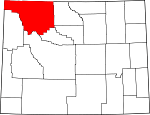 | |
| Towns | ||
| CDPs | ||
| Unincorporated communities | ||
| Ghost town | ||
| Footnotes | ‡This populated place also has portions in an adjacent county or counties | |
Yellowstone National Park - Lake and Environs | ||
|---|---|---|
Historic structures and other attractions in the Yellowstone Lake, West Thumb, South and East Entrance areas | ||
| Structures and History | 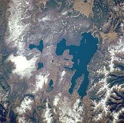 | |
| West Thumb Geyser Basin | ||
| Geography and Geology |
| |
| ||
| Authority control |
|
|---|