Benewah County, Idaho
Benewah County (/ˈbɛnəˌwɑː/) is a county located in the northwest part of the U.S. state of Idaho. As of the 2010 United States Census the county had a population of 9,285.[1] The county seat and largest city is St. Maries, which has some area inside the Coeur d'Alene Reservation.[2]
Benewah County | |
|---|---|
 | |
 Seal | |
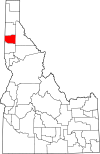 Location within the U.S. state of Idaho | |
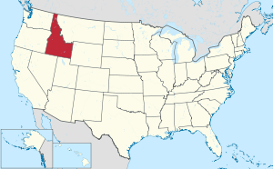 Idaho's location within the U.S. | |
| Coordinates: 47°13′N 116°40′W | |
| Country | |
| State | |
| Founded | January 23, 1915 |
| Seat | St. Maries |
| Largest city | St. Maries |
| Area | |
| • Total | 784 sq mi (2,030 km2) |
| • Land | 777 sq mi (2,010 km2) |
| • Water | 7.3 sq mi (19 km2) 0.9% |
| Population (2010) | |
| • Total | 9,285 |
| • Estimate (2018) | 9,226 |
| • Density | 12/sq mi (4.6/km2) |
| Time zone | UTC−8 (Pacific) |
| • Summer (DST) | UTC−7 (PDT) |
| Congressional district | 1st |
The county was established on January 23, 1915 of land partitioned from Kootenai County. It was named for a chief of the Coeur d'Alene Tribe.[3] The federally recognized Coeur d'Alene Tribe is based on the Coeur d'Alene Reservation in this and neighboring Kootenai County.
Geography
Benewah County lies on the west line of the state. Its west boundary line abuts the east boundary line of the state of Washington. The county has a total area of 784 square miles (2,030 km2), of which 777 square miles (2,010 km2) is land and 7.3 square miles (19 km2) (0.9%) is water.[4] It is the northern part of the Palouse, a wide and rolling prairie-like region of the middle Columbia basin.
Adjacent counties
- Spokane County, Washington – northwest
- Kootenai County – north
- Shoshone County – east
- Latah County – south
- Whitman County, Washington – southwest
National protected area
- St. Joe National Forest (part)
State protected areas
Demographics
| Historical population | |||
|---|---|---|---|
| Census | Pop. | %± | |
| 1920 | 6,997 | — | |
| 1930 | 6,371 | −8.9% | |
| 1940 | 7,332 | 15.1% | |
| 1950 | 6,173 | −15.8% | |
| 1960 | 6,036 | −2.2% | |
| 1970 | 6,230 | 3.2% | |
| 1980 | 8,292 | 33.1% | |
| 1990 | 7,937 | −4.3% | |
| 2000 | 9,171 | 15.5% | |
| 2010 | 9,285 | 1.2% | |
| Est. 2018 | 9,226 | [5] | −0.6% |
| US Decennial Census[6] 1790–1960[7] 1900–1990[8] 1990–2000[9] 2010–2018[1] | |||
2000 census
As of the 2000 United States Census,[10] there were 9,171 people, 3,580 households, and 2,538 families in the county. The population density was 12 people per square mile (5/km²). There were 4,238 housing units at an average density of 6 per square mile (2/km²). The racial makeup of the county was 88.66% White, 0.12% Black or African American, 8.94% Native American, 0.15% Asian, 0.05% Pacific Islander, 0.25% from other races, and 1.82% from two or more races. 1.55% of the population were Hispanic or Latino of any race. 26.6% were of German, 11.7% English, 9.5% American and 8.6% Irish ancestry.
There were 3,580 households out of which 31.30% had children under the age of 18 living with them, 58.40% were married couples living together, 7.70% had a female householder with no husband present, and 29.10% were non-families. 24.00% of all households were made up of individuals and 10.40% had someone living alone who was 65 years of age or older. The average household size was 2.52 and the average family size was 2.99.
The county population contained 26.90% under the age of 18, 6.80% from 18 to 24, 25.40% from 25 to 44, 26.60% from 45 to 64, and 14.20% who were 65 years of age or older. The median age was 39 years. For every 100 females there were 104.00 males. For every 100 females age 18 and over, there were 101.10 males.
The median income for a household in the county was $31,517, and the median income for a family was $36,000. Males had a median income of $35,097 versus $20,288 for females. The per capita income for the county was $15,285. About 10.50% of families and 14.10% of the population were below the poverty line, including 18.20% of those under age 18 and 9.70% of those age 65 or over.
2010 census
As of the 2010 United States Census, there were 9,285 people, 3,837 households, and 2,571 families in the county.[11] The population density was 12.0 inhabitants per square mile (4.6/km2). There were 4,629 housing units at an average density of 6.0 per square mile (2.3/km2).[12] The racial makeup of the county was 86.6% white, 8.7% Native American, 0.3% black or African American, 0.3% Asian, 0.1% Pacific islander, 0.5% from other races, and 3.6% from two or more races. Those of Hispanic or Latino origin made up 2.5% of the population.[11] In terms of European ancestry, 23.7% were German, 17.5% were Irish, 14.6% were English, 7.1% were Norwegian, and 3.4% were American.[13]
Of the 3,837 households, 29.0% had children under the age of 18 living with them, 52.8% were married couples living together, 9.3% had a female householder with no husband present, 33.0% were non-families, and 27.3% of all households were made up of individuals. The average household size was 2.40 and the average family size was 2.90. The median age was 44.8 years.[11]
The median income for a household in the county was $37,500 and the median income for a family was $41,759. Males had a median income of $37,214 versus $22,348 for females. The per capita income for the county was $18,312. About 11.2% of families and 15.2% of the population were below the poverty line, including 21.6% of those under age 18 and 5.6% of those age 65 or over.[14]
Politics
Benewah County voters tend to vote Republican in the last several decades. In only two national elections since 1968 has the county selected the Democratic Party candidate (as of 2016).
| Year | Republican | Democratic | Third parties |
|---|---|---|---|
| 2016 | 74.2% 3,103 | 18.4% 770 | 7.5% 312 |
| 2012 | 66.8% 2,596 | 30.0% 1,164 | 3.2% 125 |
| 2008 | 63.5% 2,646 | 33.8% 1,407 | 2.7% 111 |
| 2004 | 69.7% 2,823 | 28.4% 1,148 | 2.0% 79 |
| 2000 | 70.7% 2,606 | 24.3% 895 | 5.1% 186 |
| 1996 | 42.5% 1,667 | 38.0% 1,488 | 19.5% 764 |
| 1992 | 33.0% 1,223 | 34.3% 1,270 | 32.7% 1,210 |
| 1988 | 51.0% 1,650 | 46.9% 1,518 | 2.2% 70 |
| 1984 | 57.7% 2,039 | 41.0% 1,447 | 1.4% 48 |
| 1980 | 54.9% 2,111 | 35.4% 1,361 | 9.7% 374 |
| 1976 | 47.6% 1,458 | 50.6% 1,549 | 1.9% 57 |
| 1972 | 55.5% 1,494 | 39.5% 1,062 | 5.0% 134 |
| 1968 | 44.4% 1,125 | 45.8% 1,160 | 9.8% 248 |
| 1964 | 35.3% 981 | 64.7% 1,796 | |
| 1960 | 42.1% 1,274 | 58.0% 1,756 | |
| 1956 | 50.3% 1,460 | 49.7% 1,442 | |
| 1952 | 52.1% 1,568 | 47.7% 1,436 | 0.2% 7 |
| 1948 | 38.0% 1,038 | 58.2% 1,590 | 3.8% 103 |
| 1944 | 44.4% 1,173 | 54.7% 1,446 | 0.9% 24 |
| 1940 | 40.1% 1,304 | 59.2% 1,924 | 0.7% 22 |
| 1936 | 30.9% 897 | 65.7% 1,906 | 3.4% 98 |
| 1932 | 35.3% 949 | 59.6% 1,602 | 5.2% 139 |
| 1928 | 57.4% 1,343 | 41.0% 958 | 1.6% 37 |
| 1924 | 47.0% 1,158 | 12.9% 318 | 40.1% 989 |
| 1920 | 63.0% 1,351 | 37.0% 794 | |
| 1916 | 35.1% 935 | 51.5% 1,374 | 13.4% 358 |
Communities
Cities
Unincorporated communities
- Alder Creek[16][17]
- Benewah[18][19]
- Cardwell[20][21]
- Chatcolet
- Emida
- Fernwood
- Flat Creek
- Hawleys Landing[22][23]
- Lotus[24][25]
- Mashburn[26][27]
- Meadowhurst[28][29]
- Miltown[30][31]
- Mowry[32][33]
- North South Ski Bowl[34][35]
- Omega[36][37]
- Pedee[38][39]
- Plummer Junction[40][41]
- Ramsdell[42][43]
- Renfrew
- Riverdale[44][45]
- Rocky Point[46][47]
- Rover[48][49]
- Saint Joe
- Sanders[50][51]
- Santa
- Silvertip Landing[52][53]
- Tyson Creek Station[54][55]
- Wayland[56][57]
- Willard[58][59]
Images
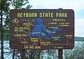 Heyburn State Park information sign
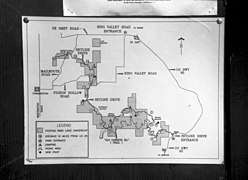 Map of McCroskey State Park
Notes
- "State & County QuickFacts". US Census Bureau. Retrieved June 28, 2014.
- "Find a County". National Association of Counties. Archived from the original on May 31, 2011. Retrieved June 7, 2011.
- "Benewah County – Idaho.gov". Archived from the original on February 5, 2015. Retrieved February 5, 2015.
- "US Gazetteer files: 2010, 2000, and 1990". United States Census Bureau. February 12, 2011. Retrieved April 23, 2011.
- "Population and Housing Unit Estimates". Retrieved September 7, 2019.
- "US Decennial Census". US Census Bureau. Retrieved June 28, 2014.
- "Historical Census Browser". University of Virginia Library. Retrieved June 28, 2014.
- "Population of Counties by Decennial Census: 1900 to 1990". US Census Bureau. Retrieved June 28, 2014.
- "Census 2000 PHC-T-4. Ranking Tables for Counties: 1990 and 2000" (PDF). US Census Bureau. Retrieved June 28, 2014.
- "U.S. Census website". US Census Bureau. Retrieved January 31, 2008.
- "Profile of General Population and Housing Characteristics: 2010 Demographic Profile Data". US Census Bureau. Archived from the original on February 13, 2020. Retrieved January 4, 2016.
- "Population, Housing Units, Area, and Density: 2010 – County". US Census Bureau. Archived from the original on 13 February 2020. Retrieved 4 January 2016.
- "Selected Social Characteristics in the US – 2006–2010 American Community Survey 5-Year Estimates". US Census Bureau. Archived from the original on February 13, 2020. Retrieved January 4, 2016.
- "Selected Economic Characteristics – 2006–2010 American Community Survey 5-Year Estimates". US Census Bureau. Archived from the original on February 13, 2020. Retrieved January 4, 2016.
- Leip, David. "Atlas of US Presidential Elections". uselectionatlas.org. Retrieved April 4, 2018.
- U.S. Geological Survey Geographic Names Information System: Alder Creek
- Google (June 10, 2019). "Alder Creek, Idaho 83861" (Map). Google Maps. Google. Retrieved June 10, 2019.
- U.S. Geological Survey Geographic Names Information System: Benewah
- Google (June 10, 2019). "Benewah, Idaho 83861" (Map). Google Maps. Google. Retrieved June 10, 2019.
- U.S. Geological Survey Geographic Names Information System: Cardwell
- Google (June 10, 2019). "Cardwell, St Maries, ID 83861" (Map). Google Maps. Google. Retrieved June 10, 2019.
- U.S. Geological Survey Geographic Names Information System: Hawleys Landing
- Google (June 10, 2019). "Hawleys Landing, Idaho 83851" (Map). Google Maps. Google. Retrieved June 10, 2019.
- U.S. Geological Survey Geographic Names Information System: Lotus
- Google (June 10, 2019). "Lotus, St Maries, ID 83861" (Map). Google Maps. Google. Retrieved June 10, 2019.
- U.S. Geological Survey Geographic Names Information System: Mashburn
- Google (June 10, 2019). "Mashburn, Idaho 83861" (Map). Google Maps. Google. Retrieved June 10, 2019.
- U.S. Geological Survey Geographic Names Information System: Meadowhurst
- Google (June 10, 2019). "Meadowhurst, Idaho 83861" (Map). Google Maps. Google. Retrieved June 10, 2019.
- U.S. Geological Survey Geographic Names Information System: Miltown
- Google (June 10, 2019). "Milltown, Idaho 83861" (Map). Google Maps. Google. Retrieved June 10, 2019.
- U.S. Geological Survey Geographic Names Information System: Mowry
- Google (June 10, 2019). "Mowry, Idaho 83851" (Map). Google Maps. Google. Retrieved June 10, 2019.
- U.S. Geological Survey Geographic Names Information System: North South Ski Bowl
- Google (June 10, 2019). "North South Ski Bowl, Idaho 83861" (Map). Google Maps. Google. Retrieved June 10, 2019.
- U.S. Geological Survey Geographic Names Information System: Omega
- Google (June 10, 2019). "Omega, Idaho 83861" (Map). Google Maps. Google. Retrieved June 10, 2019.
- U.S. Geological Survey Geographic Names Information System: Pedee
- Google (June 10, 2019). "Pedee, Idaho 83851" (Map). Google Maps. Google. Retrieved June 10, 2019.
- U.S. Geological Survey Geographic Names Information System: Plummer Junction
- Google (June 10, 2019). "Plummer Junction, Idaho 83851" (Map). Google Maps. Google. Retrieved June 10, 2019.
- U.S. Geological Survey Geographic Names Information System: Ramsdell
- Google (June 10, 2019). "Ramsdell, Idaho 83861" (Map). Google Maps. Google. Retrieved June 10, 2019.
- U.S. Geological Survey Geographic Names Information System: Riverdale
- Google (June 10, 2019). "Riverdale, Idaho 83861" (Map). Google Maps. Google. Retrieved June 10, 2019.
- U.S. Geological Survey Geographic Names Information System: Rocky Point
- Google (June 10, 2019). "Rocky Point, Idaho 83851" (Map). Google Maps. Google. Retrieved June 10, 2019.
- U.S. Geological Survey Geographic Names Information System: Rover
- Google (June 10, 2019). "Rover, St Maries, ID 83861" (Map). Google Maps. Google. Retrieved June 10, 2019.
- U.S. Geological Survey Geographic Names Information System: Sanders
- Google (June 10, 2019). "Sanders, Idaho 83870" (Map). Google Maps. Google. Retrieved June 10, 2019.
- U.S. Geological Survey Geographic Names Information System: Silvertip Landing
- Google (June 10, 2019). "Silvertip Landing, Idaho 83861" (Map). Google Maps. Google. Retrieved June 10, 2019.
- U.S. Geological Survey Geographic Names Information System: Tyson Creek Station
- Google (June 10, 2019). "Tyson Creek Station, Idaho 83830" (Map). Google Maps. Google. Retrieved June 10, 2019.
- U.S. Geological Survey Geographic Names Information System: Wayland
- Google (June 10, 2019). "Wayland, Idaho 83861" (Map). Google Maps. Google. Retrieved June 10, 2019.
- U.S. Geological Survey Geographic Names Information System: Willard
- Google (June 10, 2019). "Willard, Idaho 83851" (Map). Google Maps. Google. Retrieved June 10, 2019.
Places adjacent to Benewah County, Idaho | ||||||||||
|---|---|---|---|---|---|---|---|---|---|---|
| ||||||||||
Municipalities and communities of Benewah County, Idaho, United States | ||
|---|---|---|
| Cities | Map of Idaho highlighting Benewah County | |
| CDPs | ||
| Unincorporated communities | ||
| Indian reservation | ||
| Footnotes | ‡This populated place also has portions in an adjacent county or counties | |
Boise (capital) | ||
| Topics |
|  Seal of Idaho |
| Society | ||
| Regions | ||
| Larger cities | ||
| Smaller cities | ||
| Counties |
| |
| Authority control |
|
|---|