La Bâtie-Montgascon
La Bâtie-Montgascon is a commune in the Isère department in the Auvergne-Rhône-Alpes region of south-eastern France.[2]
La Bâtie-Montgascon | |
|---|---|
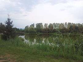 Small Trout fishing lake | |
Location of La Bâtie-Montgascon 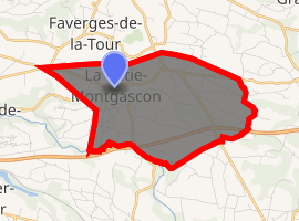
| |
 La Bâtie-Montgascon  La Bâtie-Montgascon | |
| Coordinates: 45°34′48″N 5°31′43″E | |
| Country | France |
| Region | Auvergne-Rhône-Alpes |
| Department | Isère |
| Arrondissement | La Tour-du-Pin |
| Canton | La Tour-du-Pin |
| Intercommunality | La Chaîne des Tisserands |
| Government | |
| • Mayor (2001–2020) | Gilbert Joye |
| Area 1 | 8.43 km2 (3.25 sq mi) |
| Population (2017-01-01)[1] | 1,919 |
| • Density | 230/km2 (590/sq mi) |
| Time zone | UTC+01:00 (CET) |
| • Summer (DST) | UTC+02:00 (CEST) |
| INSEE/Postal code | 38029 /38110 |
| Elevation | 314–425 m (1,030–1,394 ft) (avg. 390 m or 1,280 ft) |
| 1 French Land Register data, which excludes lakes, ponds, glaciers > 1 km2 (0.386 sq mi or 247 acres) and river estuaries. | |
The inhabitants of the commune are known as Batiolans or Batiolanes.[3]
Geography

La Bâtie-Montgascon is located some 20 km east by south-east of Bourgoin-Jallieu and 25 km west of La Motte-Servolex. Access to the commune is by the D1516 road from La Tour-du-Pin in the west which passes through the north of the commune and the village before continuing east to Aoste. The D1075 comes from Veyrins-Thuellin in the north and passes through the hamlet of Evrieu in the commune before continuing south-east to Les Abrets. The A43 autoroute passes through the south of the commune from west to east but has no exit in the commune. The nearest exit is Exit ![]()
The Bourbre forms the southern border of the commune as it flows west to eventually join the Rhône near Chavanoz.[4][5]
Neighbouring communes and villages[4] | |
|---|---|
Toponymy
La Bâtie-Montgascon appears as La Batie Mongafco on the 1750 Cassini Map[6] and as la Batie on the 1790 version.[7]
Administration
| From | To | Name | Party | Position |
|---|---|---|---|---|
| 2001 | 2020 | Gilbert Joye |
(Not all data is known)
Demography
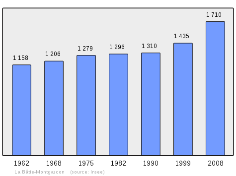
In 2010 the commune had 1,771 inhabitants. The evolution of the number of inhabitants is known from the population censuses conducted in the commune since 1793. From the 21st century, a census of communes with fewer than 10,000 inhabitants is held every five years, unlike larger communes that have a sample survey every year.[Note 1]
| 1793 | 1800 | 1806 | 1821 | 1831 | 1836 | 1841 | 1846 | 1851 |
|---|---|---|---|---|---|---|---|---|
| 1,318 | 1,545 | 1,659 | 1,844 | 1,311 | 1,361 | 1,381 | 1,379 | 1,485 |
| 1856 | 1861 | 1866 | 1872 | 1876 | 1881 | 1886 | 1891 | 1896 |
|---|---|---|---|---|---|---|---|---|
| 1,471 | 1,462 | 1,523 | 1,565 | 1,524 | 1,555 | 1,547 | 1,386 | 1,375 |
| 1901 | 1906 | 1911 | 1921 | 1926 | 1931 | 1936 | 1946 | 1954 |
|---|---|---|---|---|---|---|---|---|
| 1,302 | 1,260 | 1,263 | 1,178 | 1,171 | 1,186 | 1,123 | 1,104 | 1,116 |
| 1962 | 1968 | 1975 | 1982 | 1990 | 1999 | 2006 | 2010 | - |
|---|---|---|---|---|---|---|---|---|
| 1,158 | 1,206 | 1,279 | 1,296 | 1,310 | 1,435 | 1,657 | 1,771 | - |
Local Culture and Heritage
Sites and Monuments
- An Ancient hilltop village
- The Chateau de Renodel
- A Church from the 19th century
Cultural Heritage
- A Living Museum of Dauphinois weaving
- A Multipurpose meeting hall (work completed in 2009)
Notable people linked to the commune
- Dr Victor Prunelle (1777-1853). Owner of the Château du Vion, his tomb is in the cemetery at La Bätie-Montgascon. A doctor and politician, he was MP for Isère, mayor of Lyon and of Vichy. He tried to quell the revolt of the Canuts in Lyon (21–24 November 1831).
- Pierre Marion (1914-2000) born in La Bâtie-Montgascon. Heart surgeon, he devoted his life to the development of artificial heart valves
- Gérard Nicoud had a bar-restaurant in La Bâtie-Montgascon.
- Patrick Piot, professional motorcycle driver, born in 1967 at Bourgoin-Jallieu, lives in La Bâtie-Montgascon.
See also
Notes and references
Notes
- At the beginning of the 21st century, the methods of identification have been modified by Law No. 2002-276 of 27 February 2002, the so-called "law of local democracy" and in particular Title V "census operations" allows, after a transitional period running from 2004 to 2008, the annual publication of the legal population of the different French administrative districts. For communes with a population greater than 10,000 inhabitants, a sample survey is conducted annually and the entire territory of these communes is taken into account at the end of the period of five years. The first "legal population" after 1999 under this new law came into force on 1 January 2009 and was based on the census of 2006.
References
- "Populations légales 2017". INSEE. Retrieved 6 January 2020.
- La Bâtie-Montgascon on Lion1906
- Inhabitants of Isère (in French)
- La Bâtie-Montgascon on Google Maps
- La Bâtie-Montgascon on the Géoportail from National Geographic Institute (IGN) website (in French)
- La Batie Mongafco on the 1750 Cassini Map
- la Batie on the 1790 Cassini Map
- List of Mayors of France (in French)
External links
- Dauphinois Weaving Living Museum website (in French)
- La_Bâtie-Montgascon Official website (in French)
| Wikimedia Commons has media related to La Bâtie-Montgascon. |
| Authority control |
|
|---|