Les Abrets
Les Abrets is a former commune in the Isère department in the Auvergne-Rhône-Alpes region of southeastern France. On 1 January 2016, it was merged into the new commune of Les Abrets-en-Dauphiné.[2]
Les Abrets | |
|---|---|
Part of Les Abrets-en-Dauphiné | |
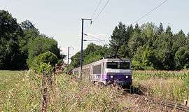 SNCF train in Les Abrets | |
.svg.png) Coat of arms | |
Location of Les Abrets 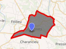
| |
 Les Abrets  Les Abrets | |
| Coordinates: 45°32′15″N 5°35′09″E | |
| Country | France |
| Region | Auvergne-Rhône-Alpes |
| Department | Isère |
| Arrondissement | La Tour-du-Pin |
| Canton | Chartreuse-Guiers |
| Commune | Les Abrets-en-Dauphiné |
| Area 1 | 6.89 km2 (2.66 sq mi) |
| Population (2017-01-01)[1] | 3,470 |
| • Density | 500/km2 (1,300/sq mi) |
| Time zone | UTC+01:00 (CET) |
| • Summer (DST) | UTC+02:00 (CEST) |
| Postal code | 38490 |
| Elevation | 261–434 m (856–1,424 ft) |
| 1 French Land Register data, which excludes lakes, ponds, glaciers > 1 km2 (0.386 sq mi or 247 acres) and river estuaries. | |
The inhabitants of the commune are known as Abrésiens or Abrésiennes[3]
Geography
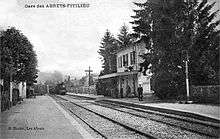
Les Abrets is located some 30 km west of Chambery and 25 km east of Bourgoin-Jallieu. The commune can be accessed on the D1075 road from the north-west continuing through the commune and the village to La Bâtie-Divisin in the south. The D1006 highway comes from La Tour-du-Pin in the west and intersects the D1075 in the centre of the village then continues to Le Pont-de-Beauvoisin in the east. There is also the D142E road from the village going north-east, the D592 which goes north from the village continuing to Chimilin, and the D142 going north-west to Fitilieu. A railway passes through the commune from west to east with a station just outside the western edge of the commune. The urban area of Les Abrets covers a large portion of the commune with a belt of forest running north to south through the centre of the commune. With some forested areas in the east of the commune and some forest in the east, the balance of the land area is farmland.[4]
The Bievre stream flows south down the eastern edge of the commune. Other streams flow near the village and to the south.[4]
Neighbouring communes and villages[4]
Places adjacent to Les Abrets | |
|---|---|
Toponymy
The term Abrets comes from Albrez Albretum or Arbreta (from the Latin Arbor: relative to a tree). This wooded area was given to the "Poor Knights of Christ" in about 1124 who then became the Knights of the Temple of Jerusalem in 1128, known under the name of the Templars.
Heraldry
Arms of Les Abrets |
Blazon: Gules, a chevron debased in Or, in chief to dexter two weaver's shuttles of argent saltirewise, to sinister a dolphin the same, in base three firs vert the middle higher. |
Administration
List of Successive Mayors of Les Abrets[5]
| From | To | Name |
|---|---|---|
| 1792 | 1804 | Paul Morand |
| 1804 | 1816 | Louis Boissier |
| 1816 | 1830 | Jacques Novel |
| 1830 | 1834 | Louis Boissier |
| 1834 | 1837 | Clément Morand |
| 1837 | 1864 | Jacques Novel |
| 1864 | 1870 | Joseph Comte |
| 1870 | 1871 | Félix Jamet |
| 1871 | 1876 | Pierre Landier |
| 1876 | 1884 | Joseph Badin |
| 1884 | 1889 | Benoît Orcel |
| 1889 | 1893 | Elisée Deschaux |
| 1893 | 1895 | Clément Humbert |
| 1895 | 1901 | Firmin Rabatel |
| 1901 | 1904 | Hippolyte Falquet |
| 1904 | 1918 | Philippe Barrier |
| 1918 | 1919 | Antoine Fougier |
| 1919 | 1935 | Eloi Cuchet |
- Mayors from 1935
| From | To | Name | Party | Position |
|---|---|---|---|---|
| 1935 | 1959 | Pierre Collomb | ||
| 1959 | 1965 | Maurice Bernard | ||
| 1965 | 1986 | Jean Janin | ||
| 1986 | 1992 | Maurice Gaillard | ||
| 1992 | 2008 | Jean-Paul Gau | ||
| 2008 | 2014 | Jean-Pierre Chabert | UMP | |
| 2014 | 2020 | François Boucly |
(Not all data is known)
Population
In 2010 the commune had 3,455 inhabitants. The evolution of the number of inhabitants is known through the population censuses conducted in the commune since 1793. From the 21st century, a census of municipalities with fewer than 10,000 inhabitants is held every five years, unlike larger towns that have a sample survey every year.[Note 1]
| 1793 | 1800 | 1806 | 1821 | 1831 | 1836 | 1841 | 1846 | 1851 |
|---|---|---|---|---|---|---|---|---|
| 763 | 688 | 834 | 1,071 | 1,203 | 1,292 | 1,347 | 1,250 | 1,297 |
| 1856 | 1861 | 1866 | 1872 | 1876 | 1881 | 1886 | 1891 | 1896 |
|---|---|---|---|---|---|---|---|---|
| 1,305 | 1,343 | 1,341 | 1,440 | 1,743 | 1,826 | 1,705 | 1,754 | 1,756 |
| 1901 | 1906 | 1911 | 1921 | 1926 | 1931 | 1936 | 1946 | 1954 |
|---|---|---|---|---|---|---|---|---|
| 1,818 | 1,923 | 1,850 | 1,773 | 1,831 | 1,954 | 1,818 | 1,890 | 2,010 |
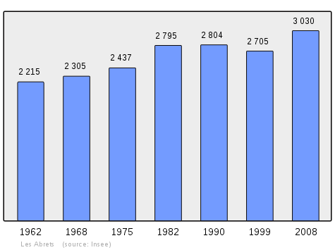
| 1962 | 1968 | 1975 | 1982 | 1990 | 1999 | 2006 | 2007 | 2010 |
|---|---|---|---|---|---|---|---|---|
| 2,215 | 2,305 | 2,437 | 2,795 | 2,804 | 2,705 | 3,007 | 3,050 | 3,455 |
Sites and Monuments
- A Church (19th century) contains a Chalice with Paten (17th century)

- The Domaine des Fauves (Abrets Zoological Park)
- Path of Pilgrimage to Saint-Jacques de Compostela: Les Abrets is located on one of the pilgrims trails
- The Bourgeat Factory makes catering equipment and stainless steel for professional kitchens
- The Centre Jean Jannin is an establishment for people with disabilities founded in 1977
- The Zoo Picture Gallery
 A Mongoose
 A Grand Duke African Owl
 A Bennett's Wallaby
Notable People linked to the commune
- Thomas Joseph-Armand Caillat, religious goldsmith, lived in the commune.
See also
External links
- Les Abrets official website (in French)
- Les Abrets on Lion1906
- Les Abrets on Géoportail, National Geographic Institute (IGN) website (in French)
- Les Abrets on the 1750 Cassini Map
- Les Abrets on the INSEE website (in French)
Notes and references
Notes
- At the beginning of the 21st century, the methods of identification have been modified by law No. 2002-276 of 27 February 2002 Archived 2016-03-06 at the Wayback Machine, the so-called "law of local democracy" and in particular Title V "census operations" which allow, after a transitional period running from 2004 to 2008, the annual publication of the legal population of the different French administrative districts. For municipalities with a population greater than 10,000 inhabitants, a sample survey is conducted annually, the entire territory of these municipalities is taken into account at the end of the period of five years. The first "legal population" after 1999 under this new law came into force on 1 January 2009 and was based on the census of 2006.
References
- "Populations légales 2017". INSEE. Retrieved 6 January 2020.
- Arrêté préfectoral 30 December 2015
- Inhabitants of Isère (in French)
- Google Maps
- List of Mayors of France (in French)
- Ministry of Culture, Palissy PM38000647 Chalice with Paten (in French)
| Wikimedia Commons has media related to Les Abrets. |
| Authority control |
|
|---|