Saint-Sauveur, Isère
Saint-Sauveur is a commune in the Isère department in southeastern France.
Saint-Sauveur | |
|---|---|
 Saint-Sauveur in 1921 | |
Location of Saint-Sauveur 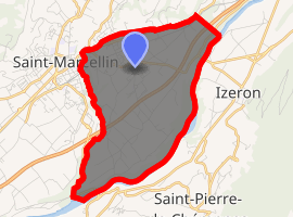
| |
 Saint-Sauveur  Saint-Sauveur | |
| Coordinates: 45°09′12″N 5°20′32″E | |
| Country | France |
| Region | Auvergne-Rhône-Alpes |
| Department | Isère |
| Arrondissement | Grenoble |
| Canton | Le Sud Grésivaudan |
| Intercommunality | Pays de Saint-Marcellin |
| Government | |
| • Mayor (2014–2020) | Michel Gentit |
| Area 1 | 9.42 km2 (3.64 sq mi) |
| Population (2017-01-01)[1] | 2,098 |
| • Density | 220/km2 (580/sq mi) |
| Time zone | UTC+01:00 (CET) |
| • Summer (DST) | UTC+02:00 (CEST) |
| INSEE/Postal code | 38454 /38160 |
| Elevation | 160–301 m (525–988 ft) (avg. 276 m or 906 ft) |
| 1 French Land Register data, which excludes lakes, ponds, glaciers > 1 km2 (0.386 sq mi or 247 acres) and river estuaries. | |
Population
| Historical population | ||
|---|---|---|
| Year | Pop. | ±% |
| 1793 | 510 | — |
| 1806 | 550 | +7.8% |
| 1821 | 666 | +21.1% |
| 1831 | 695 | +4.4% |
| 1841 | 714 | +2.7% |
| 1851 | 758 | +6.2% |
| 1861 | 733 | −3.3% |
| 1872 | 656 | −10.5% |
| 1881 | 672 | +2.4% |
| 1891 | 887 | +32.0% |
| 1901 | 915 | +3.2% |
| 1911 | 874 | −4.5% |
| 1921 | 894 | +2.3% |
| 1931 | 881 | −1.5% |
| 1946 | 827 | −6.1% |
| 1954 | 1,034 | +25.0% |
| 1962 | 1,083 | +4.7% |
| 1968 | 1,259 | +16.3% |
| 1975 | 1,426 | +13.3% |
| 1982 | 1,415 | −0.8% |
| 1990 | 1,481 | +4.7% |
| 1999 | 1,676 | +13.2% |
| 2006 | 1,858 | +10.9% |
| 2011 | 1,993 | +7.3% |
Transport
There is a train station in the nearby town of Saint Marcellin
See also
References
| Wikimedia Commons has media related to Saint-Sauveur (Isère). |
- "Populations légales 2017". INSEE. Retrieved 6 January 2020.
| Authority control |
|
|---|
This article is issued from Wikipedia. The text is licensed under Creative Commons - Attribution - Sharealike. Additional terms may apply for the media files.