La Chapelle-de-Surieu
La Chapelle-de-Surieu is a commune in the Isère department in southeastern France.
La Chapelle-de-Surieu | |
|---|---|
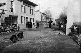 A view of La Chapelle de Surieu, in 1909 | |
Location of La Chapelle-de-Surieu 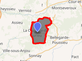
| |
 La Chapelle-de-Surieu  La Chapelle-de-Surieu | |
| Coordinates: 45°23′31″N 4°54′38″E | |
| Country | France |
| Region | Auvergne-Rhône-Alpes |
| Department | Isère |
| Arrondissement | Vienne |
| Canton | Roussillon |
| Intercommunality | Pays Roussillonnais |
| Government | |
| • Mayor (2014–2020) | Gabriel Girard |
| Area 1 | 11.22 km2 (4.33 sq mi) |
| Population (2017-01-01)[1] | 751 |
| • Density | 67/km2 (170/sq mi) |
| Time zone | UTC+01:00 (CET) |
| • Summer (DST) | UTC+02:00 (CEST) |
| INSEE/Postal code | 38077 /38150 |
| Elevation | 252–407 m (827–1,335 ft) |
| 1 French Land Register data, which excludes lakes, ponds, glaciers > 1 km2 (0.386 sq mi or 247 acres) and river estuaries. | |
Population
| Historical population | ||
|---|---|---|
| Year | Pop. | ±% |
| 1793 | 474 | — |
| 1800 | 448 | −5.5% |
| 1821 | 587 | +31.0% |
| 1831 | 584 | −0.5% |
| 1841 | 615 | +5.3% |
| 1851 | 548 | −10.9% |
| 1861 | 551 | +0.5% |
| 1872 | 569 | +3.3% |
| 1881 | 563 | −1.1% |
| 1891 | 508 | −9.8% |
| 1901 | 506 | −0.4% |
| 1911 | 468 | −7.5% |
| 1921 | 427 | −8.8% |
| 1931 | 403 | −5.6% |
| 1946 | 392 | −2.7% |
| 1954 | 374 | −4.6% |
| 1962 | 362 | −3.2% |
| 1968 | 345 | −4.7% |
| 1975 | 289 | −16.2% |
| 1982 | 326 | +12.8% |
| 1990 | 409 | +25.5% |
| 1999 | 477 | +16.6% |
| 2011 | 699 | +46.5% |
See also
References
- "Populations légales 2017". INSEE. Retrieved 6 January 2020.
| Wikimedia Commons has media related to La Chapelle-de-Surieu. |
| Authority control |
|
|---|
This article is issued from Wikipedia. The text is licensed under Creative Commons - Attribution - Sharealike. Additional terms may apply for the media files.