Massachusetts Route 125
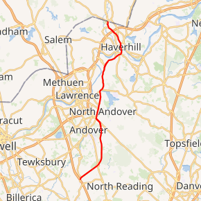
Route 125 is an 18.90-mile-long (30.42 km) Massachusetts state route that, while running southwest to northeast, is signed north–south. It runs from Interstate 93 in Wilmington to the Massachusetts-New Hampshire state line in Haverhill, where it continues as New Hampshire Route 125 through Plaistow to Wakefield, New Hampshire. After the first 1.7 miles (2.7 km), which are in Middlesex County, the rest of the route passes through Essex County.
| ||||
|---|---|---|---|---|
Route 125 highlighted in red | ||||
| Route information | ||||
| Maintained by MassDOT | ||||
| Length | 18.90 mi[1] (30.42 km) | |||
| Major junctions | ||||
| South end | ||||
| North end | ||||
| Location | ||||
| Counties | Middlesex, Essex | |||
| Highway system | ||||
| ||||

Route description
Route 125 begins at I-93, at exit 41, just south of where I-93 drops from four lanes to three. It passes through an area of industrial parks before clipping the northwest corner of North Reading and entering Andover. Once in Andover, the road serves as a bypass road around much of Andover's busier sections. It intersects Route 28 with a cloverleaf interchange as it bends northward through town. The route then enters North Andover, becoming concurrent with Route 114 for half a mile as the two routes pass Merrimack College. Route 125 then splits northward, becoming concurrent with Route 133 again acting as a bypass, this time between North Andover's more densely populated west end and its historical center. The two routes split at a point between Lawrence Municipal Airport and Lake Cochichewick in the northern end of town.
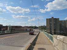
From there, Route 125 passes into Haverhill in the Bradford section of town. In Bradford, Route 125 meets a connector road between it and I-495 which passes through an industrial area. The route then continues through the Bradford area before crossing the Merrimack River at the Basiliere Bridge. Once it crosses the bridge into the downtown Haverhill area, Route 125 crosses Route 113 before sharing a one-block concurrency with Route 97 and a two-block concurrency with Route 110 in quick succession. The route then turns more northwesterly, crossing I-495 directly at Exits 51 A-B. The route turns northward at Plaistow Road before entering into Plaistow, New Hampshire and becoming New Hampshire Route 125. Main Street, meanwhile, heads into Plaistow as well, where it meets the end of New Hampshire Route 121.
Major intersections
| County | Location | mi | km | Destinations | Notes |
|---|---|---|---|---|---|
| Middlesex | Wilmington | 0.00 | 0.00 | Southern terminus; I-93 exit 35 (formerly exit 41) | |
| Essex | Andover | 2.4 | 3.9 | Cloverleaf intersection | |
| North Andover | 6.9 | 11.1 | Southern end of Route 114 concurrency | ||
| 7.4 | 11.9 | Northern end of Route 114 concurrency | |||
| 7.7 | 12.4 | Southern end of Route 133 concurrency | |||
| 10.4 | 16.7 | Northern end of Route 133 concurrency | |||
| Haverhill | 13.0 | 20.9 | Connector road to exit 106 on I-495 (formerly exit 48) | ||
| 15.7 | 25.3 | ||||
| 15.8 | 25.4 | Brief concurrency with Route 97 for one block | |||
| 16.0 | 25.7 | Brief concurrency with Route 110 for one block | |||
| 17.7 | 28.5 | Exit 109 on I-495 (formerly exit 51) | |||
| 18.6 | 29.9 | Becomes NH Route 121 at NH border | |||
| 18.8 | 30.3 | Becomes NH Route 121A at NH border; signed as Massachusetts Route 121A | |||
| 18.90 | 30.42 | Northern terminus | |||
1.000 mi = 1.609 km; 1.000 km = 0.621 mi
| |||||