Government Center, Boston
Government Center is an area in downtown Boston, centered on City Hall Plaza. Formerly the site of Scollay Square, it is now the location of Boston City Hall, courthouses, state and federal office buildings, and a major MBTA subway station, also called Government Center. Its development was controversial, as the project displaced thousands of residents and razed several hundred homes and businesses.[1]
History
A 1958 report by the Boston Planning Board, entitled Government Center Project, set out the case for construction of a center: "The future of Boston depends in large degree on how effectively and efficiently it continues to perform its role as the central city of an important metropolitan area and as the regional center for New England. ... One of the basic functions of such a regional center is the provision of governmental services at all levels. ... At the present time the accommodations in Boston for all levels of government are inadequate and inefficient." [2]
Major structures
Boston City Hall

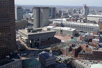
The dominant feature of Government Center is the enormous, imposing, and brutalist Boston City Hall,[3] designed by Kallmann McKinnell & Wood and built in the 1960s as part of Boston's first large urban renewal scheme. While considered by some to have architectural merit, the building is not universally admired, and is sharply unpopular among locals. Furthermore, it is resented for having replaced the Victorian architecture of Boston's Scollay Square,[4] a lively commercial district that lapsed into squalor in the twentieth century.[5]
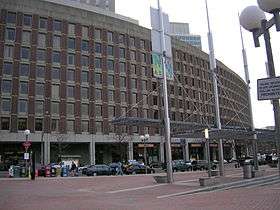
John Fitzgerald Kennedy Federal Building
John Fitzgerald Kennedy Federal Building is a United States government office building. It is located across City Hall Plaza from Boston City Hall. An example of 1960s modern architecture, it consists of two 26 floor towers that sit on-axis to each other and a low rise building of four floors that connects to the two towers via an enclosed glass corridor. The two towers stand at a height of 118 meters (387 ft).
City Hall Plaza

City Hall Plaza is not a well-loved space, either. As Bill Wasik wrote in 2006, "It is as if the space were calibrated to render futile any gathering, large or small, attempted anywhere on its arid expanse. All the nearby buildings seem to be facing away, making the plaza's 11 acres (45,000 m2) of concrete and brick feel like the world's largest back alley. … [It is] so devoid of benches, greenery, and other signposts of human hospitality that even on the loveliest fall weekend, when the Common and Esplanade and other public spaces teem with Bostonians at leisure, the plaza stands utterly empty save for the occasional skateboarder…"[6] The plaza is often colloquially referred to as "the brick desert."[7]
Government Service Center

Another very large Brutalist building at Government Center, less prominently located and thus less well known than City Hall, is the Government Service Center, designed by architect Paul Rudolph. The building is unfinished as the tall central tower in the original plan was never built. In the mid-1990s, the adjacent space was filled with the Edward W. Brooke Courthouse, which houses a division of the Boston Municipal Court. This irregularly shaped, sloping lot was the last parcel to be developed of the Government Center urban renewal plan; in the interim the space was used as surface parking. In a 2014 article, architectural historian Timothy M. Rohan praised the building for having "a wondrous interior courtyard like something from baroque Rome, a space that even in its incomplete and neglected state contrasts sharply with nearby City Hall and its alienating plaza." [8]
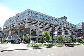
Government Center Garage
This 2,300-space privately owned garage[9] was built as part of the Government Center urban renewal project. In 2016, the Boston Redevelopment Authority gave final approval[10] for the replacement of the garage with "Bulfinch Crossing,"[11] a 2.9-million-square-foot (270,000 m2) mixed-use development[12][13][14] designed by Pelli Clarke Pelli Architects.[15] Construction began in January 2017.[16] The design of the office tower was revealed in June 2019.[17]
Center Plaza
This 720,000 square foot (67,000 m2) office and retail structure, built by developer Norman B. Leventhal, is across Cambridge Street from City Hall Plaza. In 2014, the property was sold[18] by the Blackstone Group to Shorenstein Properties.[19] Shorenstein Properties has proposed a $25 million renovation[20] designed "to add some new buzz" to the building.[21] The renovation was approved by the Boston Redevelopment Authority in 2016.[22]
Nearby public buildings
Several state and federal government buildings near Government Center were not built as part of the urban renewal project. These include the Massachusetts State House, the McCormack Building, the Saltonstall Building,[23] the Suffolk County Courthouse, and the Thomas P. O'Neill Jr. Federal Building. Some of these buildings are considered, in Wikipedia listings and other sources, to be located in Government Center.
Geography and transportation
Government Center is located between the North End, Downtown, and Beacon Hill neighborhoods.
Boundaries
Government Center does not have official boundaries. A 2011 Boston Redevelopment Authority map of Boston neighborhoods[24] shows most of the Government Center area as part of the Downtown neighborhood, and the rest as part of the West End.
Other maps and documents show a variety of different boundaries for Government Center. The Boston Zoning Code has a map called "1H Government Center/Markets District."[25] The map shows the Government Center portion of the district extending as far west as the Massachusetts State House and including all of the major structures listed in this article. The Boston Redevelopment Authority map of "Urban Renewal Areas"[26] includes a somewhat smaller area that excludes the McCormack and Saltonstall Buildings.
By contrast, a search for "Government Center" on Google Maps[27] yields a map showing an even smaller area that is bounded by Court, Cambridge, Sudbury, and Congress Streets. The AirBnB neighborhood map[28] shows a somewhat larger area than the Google Map. An undated Boston Redevelopment Authority map entitled "Government Center Urban Renewal Area Illustrative Site Plan" [29] showed similar boundaries.
Mass transit
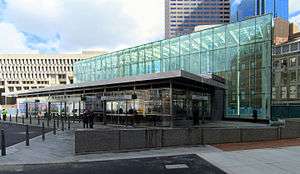
Scollay Square station opened as part of the third phase of the Tremont Street Subway in September 1898, bringing subway service to the area with a stone headhouse in the center of the square. Court Street station opened on the East Boston Tunnel in December 1904; it was closed in 1914 and replaced by a lower level (Scollay Under) to the Scollay Square station in 1916.[30] The station was rebuilt in 1963 as Government Center station with a low brick headhouse, and again from 2014-2016 with a large glass headhouse that dominates the south side of the plaza.[31] It serves as the transfer point between the MBTA's Blue and Green Lines.
Surroundings
Government Center is adjacent to historic Faneuil Hall and popular Quincy Market and very near the Old State House. It is two blocks away from the Rose Fitzgerald Kennedy Greenway, which was created as part of the Big Dig. Major city streets in the vicinity include Tremont, Congress, Cambridge, State, New Chardon, and Washington Streets. Hints of another street, Cornhill, still exist along one edge of City Hall Plaza. Two of the neighborhood's few remaining old buildings, the Sears' Crescent and Sears' Block, face the plaza and follow the original curve of Cornhill. A veteran's home & services provider, [32] still has an entrance with a Cornhill address. Plans for Government Center, including the Boston Redevelopment Authority's "Government center 2000 project",[33] called for the construction of two footbridges over Congress Street to connect City Hall Plaza to the Faneuil Hall area. Neither bridge was built.
In popular culture
- Boston-based seminal proto-punk band The Modern Lovers recorded a song called "Government Center". It was originally released on Beserkley's Chartbusters sampler album. It has been included in re-release versions of The Modern Lovers album. In it, singer Jonathan Richman humorously croons about his intent to "Rock non-stop tonight at the Government Center" to "Make the secretaries feel better / When they put the stamps on the letter." The song appears in the film Harmony and Me.
- Ska/punk band Jaya The Cat recorded a song titled "Government Center". The song references the Ashmont and Central MBTA stations.
- Long Island rock band Brand New, on their debut album Your Favorite Weapon, included a song called "Logan to Government Center".
- The Government Service Center building played the role of the Massachusetts State Police headquarters in the 2006 film The Departed.
- Government Center is featured prominently in several scenes of the 1973 film The Friends of Eddie Coyle.
See also
History of the site
Gallery
 Government Center Garage
.JPG) Saltonstall Building (100 Cambridge Street)
Saltonstall Building (100 Cambridge Street)
 City Hall under construction in the 1960s
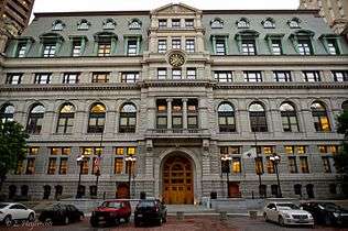 Suffolk County Courthouse
 Edward W. Brooke Courthouse
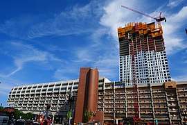 Government Center Garage during its redevelopment as Bulfinch Crossing, 2019
References
Notes
- Government center: map and directory of business firms each employing twenty or more persons. Boston Redevelopment Authority. 1961. Retrieved 22 April 2020.
- Government Center Project (PDF) (Report). Boston City Planning Board. January 1958. Retrieved 29 April 2020.
- Southworth & Southworth. AIA Guide to Boston, 3rd ed. 2008; p.52.
- "History of Scollay Square". BambinoMusical.com. Retrieved 13 April 2016.
- Mapping Boston, Krieger, Alex, ed., MIT Press 1999, p.163-165. Lost Boston, by Jane Holtz Kay, p.110.
- Wasik, Bill (2009). And Then There's This: How Stories Live and Die in Viral Culture. Viking. ISBN 978-0670020843.
- Ulam, Alex. "Softening Boston's City Hall". The Architect's Newspaper. Retrieved 13 April 2016.
- Rohan, Timothy M. (7 September 2014). "The dream behind Boston's forbidding Government Service Center". Boston Globe. Retrieved 17 September 2016.
- "Government Center Garage". Retrieved 13 April 2016.
- Logan, Tim (15 January 2016). "Government Center Garage to give way to two glass skyscrapers". Boston Globe. Retrieved 13 April 2016.
- "Bulfinch Crossing". HYM Investment Group. Retrieved 22 June 2016.
- Ross, Casey (23 June 2011). "Ambitious plan for Government Center Garage site". Boston Globe. Retrieved 13 April 2016.
- Logan, Tim (26 May 2016). "In Government Center, a nifty development trick". Boston Globe. Retrieved 29 April 2020.
- "Government Center Garage Redevelopment". BostonRedevelopmentAuthority.org. Retrieved 13 April 2016.
- "One Congress at Bulfinch Crossing". Pelli Clarke Pelli Architects. Retrieved 29 April 2020.
- Acitelli, Tom. "Bulfinch Crossing construction officially starts". Curbed Boston. Retrieved 31 January 2017.
- Cogley, Bridget (28 June 2019). "Pelli Clarke Pelli unveils folded glass One Congress tower in Boston". Dezeen. Retrieved 15 August 2019.
- Grillo, Thomas (9 January 2014). "Blackstone's Equity Office sells 1-3 Center Plaza for $307 million". Boston Business Journal. Retrieved 16 April 2016.
- "Center Plaza". Shorenstein Properties.
- "Center Plaza". Retrieved 27 August 2016.
- Carlock, Catherine (27 July 2015). "Shorenstein's planned $25M renovation of Center Plaza in downtown Boston". Boston Business Journal. Retrieved 16 April 2016.
- "Center Plaza". Boston Redevelopment Authority. Retrieved 16 April 2016.
- "The Saltonstall Building". Restoring the Urban Fabric. Matthew Lawlor. Retrieved 21 April 2016.
- "Boston Neighborhoods". BostonRedevelopmentAuthority.org. Retrieved 21 April 2016.
- "Map 1H Government Center/Markets District". Boston Redevelopment Authority. Retrieved 12 November 2016.
- "Urban Renewal Areas". BostonRedevelopmentAuthority.org. Retrieved 21 April 2016.
- "Government Center". Google Maps. Retrieved 16 April 2016.
- "Government Center". AirBnB. Retrieved 17 April 2016.
- "Government Center Urban Renewal Area Illustrative Site Plan". Boston Redevelopment Authority. Retrieved 13 June 2015.
- Belcher, Jonathan (19 March 2016). "Changes to Transit Service in the MBTA district 1964-2016" (PDF). NETransit. Retrieved 21 March 2016.
- Moskowitz, Eric (21 March 2016). "Government Center reopens". Boston Globe. Retrieved 21 March 2016.
- "New England Center and Home for Veterans". Retrieved 21 April 2016.
- Government center 2000 project. Boston Redevelopment Authority. 12 December 1988. p. 22. Retrieved 22 April 2020.
Further reading
- Boston Redevelopment Authority. (1963), Reuse appraisal: government center urban renewal project, Boston, Massachusetts, OL 23330107M
- Boston Redevelopment Authority. (1964), Government center progress report, OL 23302007M
- Boston Redevelopment Authority. (1988), Northern downtown district study: bulfinch triangle, government center, state street, Faneuil Hall marketplace, OL 23366203M
- Boston Redevelopment Authority. (1989), Government center plan, OL 23417229M
- Sarah Schweitzer. In praise of ugly buildings. Boston Globe, January 24, 2010.
- Tufts University, FAH 198-05 Government Center
- O'Connor, Thomas H. (10 August 1995). Building a New Boston. Northeastern University Press. ISBN 9781555532468. Retrieved 11 May 2020.
External links
| Wikimedia Commons has media related to: |
- "i: six nonlectures" by e.e. cummings, footnote
- Sophie and the Suburbs, Jewish Week, Sept. 27 2002
- (https://web.archive.org/web/20070616173402/http://www.tsomides.com/news/downloads/EditorCityHallPlaza2.pdf)
- https://www.flickr.com/photos/arthurohm/sets/72157623853538550
- https://www.flickr.com/photos/gigharmon/sets/72157606318827540