Chittoor district
Chittoor district (![]()
Chittoor district | |
|---|---|
 | |
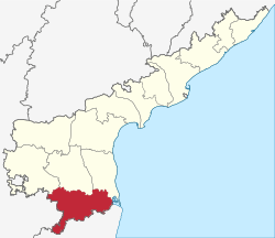 Location of Chittoor district in Andhra Pradesh | |
| Coordinates: 14°28′N 78°49′E | |
| Country | India |
| State | Andhra Pradesh |
| Headquarters | Chittoor |
| Administrative Divisions |
|
| Government | |
| • District collector | Dr.N. Bharath Gupta IAS Collector and District Magistrate |
| • Lok Sabha | Lok Sabha list
|
| • Assembly | Assembly list
|
| Area | |
| • District of Andhra Pradesh | 15,151 km2 (5,850 sq mi) |
| • Urban [1]:14 | 318.62 km2 (123.02 sq mi) |
| • Rural [1]:14 | 14,832.38 km2 (5,726.81 sq mi) |
| Area rank | 8th |
| Population (2011)[2] | |
| • District of Andhra Pradesh | 4,174,064 |
| • Rank | 6th |
| • Density | 275/km2 (710/sq mi) |
| • Density rank | 13th |
| • Urban [1]:14 | 1,231,386 |
| • Rural [1]:14 | 2,942,678 |
| • Households | 706,204 |
| • Sex ratio | 985 (females per 1,000 males) |
| Languages | |
| • Official | Telugu demographics_type2 = Literacy |
| Time zone | UTC+5:30 (IST) |
| Postal Index Number | 517xxx |
| Area codes | +91–8572 |
| ISO 3166 code | IN-AP |
| Vehicle registration | AP–39 (from 30 January 2019)[3] |
| Website | www |

History
After the Indian independence in 1947, Chittoor became a part of the erstwhile Madras state. The modern Chittoor District was formerly North Arcot District, which was established by the British in the 19th century had Chittoor as its headquarters . On 1 April 1911, district was split into Chittoor District and North Arcot District.
Chittoor District was formed on 1 April 1911, taking Chittoor, Palamaneru, Chandragiri from the then North Arcot District of Madras State and Madanapalli, Vayalpadu from Kadapa and Punganur, Sri Kalahasti, Karvetinagar from Zamindari tahsils of the Chittoor district to form united Chittoor district. In 1960, 319 villages in Chittoor district were added into Chingleput District now Kanchipuram district and Thiruvallur districts of Tamil Nadu and subsequently Sathyavedu and Kuppam of Chingleput District was transferred to Chittoor district on linguistic basis based on the Act called The Andhra Pradesh And Madras (Alteration Of Boundaries) Act, 1959.[6]
Chandragiri, a suburban area of Tirupati served as fourth capital of Vijayanagar empire.
Geography
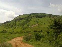
Chittoor is a part of Rayalaseema region of Andhra Pradesh.[7] The district occupies an area of 15,359 square kilometres (5,930 sq mi).[8][9] The district is bounded by Anantapur District to the northwest, Kadapa District to the north, Nellore District to the northeast, Krishnagiri District, Vellore District, Tirupathur district and Tiruvallur District of Tamil Nadu state to the south, and Kolar District of Karnataka state to the west. Chittoor district lies extreme south of the Andhra Pradesh state approximately between 12°37′ - 14°8′ north latitudes and 78°3′ - 79°55′ east longitudes. Thirty percent of the total land area is covered by forests in the district.[10] Mango and tamarind groves surround the city of Chittoor, and cattle are raised in the district. The soils in the district constitute red loamy 57%, red sandy 34% and the remaining 9% is covered by black clay black loamy, black sandy and red clay[10] Chittoor is 160 km from Chennai, 180 km from Bangalore and 590 km from Hyderabad.
Hydrology
The important rivers in the district are Ponnai and Swarnamukhi rivers which originate in eastern ghats. Other rivers include Kusasthali, Beema, Bahuda, Pincha, Kalyani, Araniyar and Pedderu. None of the rivers are perennial. Main rivers include Swarnamukhi, Kalangi, Papaghni, Koundinya, Paleru, Arani, Pinchcha, Cheyyeru, Neeva and Kusasthali
Climate
The temperature in the western parts of the district like Punganur, Madanapalle, Horsley Hills are relatively lower than the eastern parts of the Chittoor District. This is because of the higher altitude of the western parts compared to the eastern parts. The summer temperatures touches 46 °C in the eastern parts whereas in the western parts it ranges around 36° to 38 °C. Similarly the winter temperatures of the western parts are relatively low ranging around 12 °C to 14 °C and in eastern parts it is 16 °C to 18 °C.[11]
Chittoor district receives an annual rainfall of 918.1 mm. The South West Monsoon and North East Monsoon are the major sources of rainfall for the district. On average the district receives 438.0 mm of rainfall through the South West Monsoon (From June to September) and 396.0 mm from North East Monsoon (From October to December). The rainfall received by the district in the years 2002 and 2003 are 984.2 mm and 934 mm respectively.[12]
Demographics
According to the 2011 census Chittoor district has a population of 4,174,064.[13][14][15] This gives it a ranking of 47th in India (out of a total of 640)and 6th in its state.[13] The district has a population density of 275 inhabitants per square kilometre (710/sq mi) .[13] Its population growth rate over the decade 2001–2011 was 11.33%.[13] Chittoor has a sex ratio of 1002 females for every 1000 males,[13] and a literacy rate of 72.36%.[13]
In 2007–2008 the International Institute for Population Sciences interviewed 1010 households in 38 villages across the district.[16] They found that 92.7% had access to electricity, 99.6% had drinking water, 33.3% toilet facilities, and 53.8% lived in a pucca (permanent) home.[16] 29.3% of girls wed before the legal age of 18[17] and 88.2% of interviewees carried a BPL card.[16]
Telugu,[18] Tamil,[18] Kannada[18] and English are official languages.[18]
| Historical population | ||
|---|---|---|
| Year | Pop. | ±% p.a. |
| 1901 | 1,118,706 | — |
| 1911 | 1,171,614 | +0.46% |
| 1921 | 1,203,748 | +0.27% |
| 1931 | 1,324,770 | +0.96% |
| 1941 | 1,490,095 | +1.18% |
| 1951 | 1,657,560 | +1.07% |
| 1961 | 1,905,344 | +1.40% |
| 1971 | 2,267,413 | +1.75% |
| 1981 | 2,737,316 | +1.90% |
| 1991 | 3,261,118 | +1.77% |
| 2001 | 3,745,875 | +1.40% |
| 2011 | 4,174,064 | +1.09% |
| source:[19] | ||
Divisions
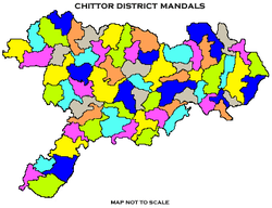
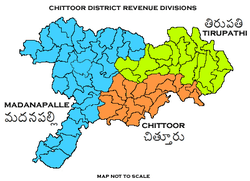
The district is divided into 3 revenue divisions viz., Chittoor, Tirupati and Madanapalle.[20] Each revenue division is divided into mandals. The district has 66 mandals under these 3 revenue divisions.[21] There are 2 Municipal Corporations of Chittoor and Tirupati and 6 municipalities of Madanapalle, Punganur, Palamaner, Nagari, Srikalahasti and Puttur in the district.[1]
Politics
There are 14 Andhra Pradesh Legislative Assembly MLA constituencies in Chittoor district.[22]
Economy

The Gross District Domestic Product (GDDP) of the district is ₹34,742 crore (US$4.9 billion) and it contributes 6.6% to the Gross State Domestic Product (GSDP). For the FY 2013–14, the per capita income at current prices was ₹64,671 (US$910). The primary, secondary and tertiary sectors of the district contribute ₹8,226 crore (US$1.2 billion), and ₹18,849 crore (US$2.6 billion) respectively.[23] The major products contributing to the GVA of the district from agriculture and allied services are, sugarcane, groundnut, tomato, mango, milk, meat and fisheries. The GVA to the industrial and service sector is contributed from construction, electricity, manufacturing, education and ownership of dwellings.[23]
In 2006 the Indian government named Chittoor one of the country's 250 most backward districts (out of a total of 640).[24] It is one of the thirteen districts in Andhra Pradesh currently receiving funds from the Backward Regions Grant Fund Programme (BRGF).[24]
Notable people
- Saptagiri (actor), Telugu film actor
- Ramaprabha, actress
- Shobha Raju, musician, devotional singer, writer and composer, an exponent of sankirtana of the gospel of the 15th-century saint-composer, Annamacharya
- Chittor V. Nagaiah, film actor
- Jiddu Krishnamurti, philosopher
- Madabhushi Ananthasayanam Ayyangar, first deputy speaker and second Speaker of Lok Sabha
- Madhurantakam Rajaram, writer, Sahitya Akademi Award winner
- Mumtaz Ali, philosopher and educationist.
- Mohan Babu, film actor
- Nara Chandrababu Naidu, Former Chief Minister Of United Andhra Pradesh(1995-2004) and first Chief Minister of Residual State Of Andhra Pradesh(2014-2019)
- N. Kiran Kumar Reddy, Former Chief Minister of Andhra Pradesh(2010-2014)
- Gali Muddu Krishnama Naidu, politician
- P. Chinnamma Reddy, politician
- Pratap C Reddy, founder of Apollo Hospitals
- Ramachandra Naidu Galla, founder & Chairman of Amara Raja Group of Industries
- Raj Reddy, a Computer Scientist and winner of Turing Award
- Sir C.R. Reddy, educationalist, founder and vice-chancellor of Andhra University
- D. K. Adikesavulu Naidu, Member of Parliament
- Roja (actress),actress
- Shafi (actor),film actor
- Bindu Madhavi,film actress
- Bhuvaneswari (actress),film actress
Transport
The district has road connectivity by means of national and state highways. The main part of the National Highways runs through Chittoor City National Highway 69 and National Highway 40 that connects the main metro cities of South India from Bangalore to Chennai. National Highway 71 connecting Madanapalle and Nayudupeta; NH 716 connecting Chennai in Tamil Nadu passes through the district.[25] The total road length of state highways in the district is 1,103 km (685 mi).[26]
Education
The primary and secondary school education is imparted by government, aided and private schools, under the School Education Department of the state.[27][28] As per the school information report for the academic year 2015–16, there are a total of 6,100 schools. They include, 45 government, 4,507 mandal and zilla parishads, 2 residential, 1,268 private, 17 model, 20 Kasturba Gandhi Balika Vidyalaya (KGBV), 158 municipal and 84 other types of schools.[29] The total number of students enrolled in primary, upper primary and high schools of the district are 562,504.[30] Chittoor district is home to the National Atmospheric Research Laboratory (NARL) of the Department of Space. The lab is involved in carrying out fundamental and applied research in Atmospheric and Space Sciences.
Temples
There are forty-three temples under the management of Endowments Department[31]
References
- "District Census Handbook – Chittoor" (PDF). Census of India. p. 19,21,58. Retrieved 29 January 2016.
- "Population". Census of India. Registrar General and Census Commissioner of India. Retrieved 14 June 2019.
- "New 'AP 39' code to register vehicles in Andhra Pradesh launched". The New Indian Express. Vijayawada. 31 January 2019. Retrieved 9 June 2019.
- "Census of India 2011" (PDF). censusindia.gov.in.
- Biju, [editor], M.R. (2009). Democratic political process. New Delhi, India: Mittal Publications. p. 235. ISBN 978-81-8324-237-0. Retrieved 17 November 2015.CS1 maint: extra text: authors list (link)
- "The Andhra Pradesh And Madras (Alteration Of Boundaries) Act, 1959". indiankanoon.org. Retrieved 23 December 2019.
- "The District Of Seven Hills – Tirumala". Archived from the original on 21 June 2012.
- Srivastava, Dayawanti et al. (ed.) (2010). "States and Union Territories: Andhra Pradesh: Government". India 2010: A Reference Annual (54th ed.). New Delhi, India: Additional Director General, Publications Division, Ministry of Information and Broadcasting (India), Government of India. pp. 1111–1112. ISBN 978-81-230-1617-7.CS1 maint: extra text: authors list (link)
- "Island Directory Tables: Islands by Land Area". United Nations Environment Program. 18 February 1998. Retrieved 11 October 2011.
Nordaustlandet 14,467
- "National Informatics Center, Chittoor". Chittoor.nic.in. 28 June 2005. Archived from the original on 11 May 2012. Retrieved 4 November 2012.
- "Chittoor district". Atmachittoor.com. Archived from the original on 29 April 2012. Retrieved 4 November 2012.
- "Irrigation". Irrigation.cgg.gov.in. Archived from the original on 9 August 2008. Retrieved 4 November 2012.
- "District Census 2011". Census2011.co.in. 2011. Retrieved 30 September 2011.
- US Directorate of Intelligence. "Country Comparison:Population". Retrieved 1 October 2011.
Lebanon 4,143,101 July 2011 est.
- "2010 Resident Population Data". U. S. Census Bureau. Archived from the original on 19 October 2013. Retrieved 30 September 2011.
Kentucky 4,339,367
- "District Level Household and Facility Survey (DLHS-3), 2007-08: India. Andhra Pradesh" (PDF). International Institute for Population Sciences and Ministry of Health and Family Welfare. 2010. Retrieved 3 October 2011.
- "How Do I? : Obtain Marriage Certificate". National Portal Content Management Team, National Informatics Centre. 2005. Retrieved 3 October 2011.
To be eligible for marriage, the minimum age limit is 21 for males and 18 for females.
- Human, International Res Jour Managt Socio. "MULTILINGUALISM IN CHITTOOR DISTRICT OF ANDHRA PRADESH". Cite journal requires
|journal=(help) - Decadal Variation In Population Since 1901
- "Industrial Profile – Chittoor District" (PDF). Commissionerate of Industries – Government of Andhra Pradesh. p. 4. Retrieved 15 June 2015.
- "Mandals in Chittoor district". AP State Portal. Archived from the original on 24 December 2014. Retrieved 24 May 2014.
- "District-wise Assembly-Constituencies in Andhra Pradesh". Ceoandhra.nic.in. Retrieved 4 November 2012.
- "Economy of Chittoor District". Andhra Pradesh Economic Development Board. Retrieved 25 April 2017.
- Ministry of Panchayati Raj (8 September 2009). "A Note on the Backward Regions Grant Fund Programme" (PDF). National Institute of Rural Development. Archived from the original (PDF) on 5 April 2012. Retrieved 27 September 2011.
- "List of National Highways passing through A.P. State". Roads and Buildings Department. Government of Andhra Pradesh. Archived from the original on 28 March 2016. Retrieved 11 February 2016.
- "Existing State Highways" (PDF). Andhra Pradesh Road Development Corporation. Government of Andhra Pradesh. p. 1. Archived from the original (PDF) on 20 September 2018. Retrieved 11 May 2019.
- "School Education Department" (PDF). School Education Department, Government of Andhra Pradesh. Archived from the original (PDF) on 27 December 2015. Retrieved 7 November 2016.
- "The Department of School Education – Official AP State Government Portal". www.ap.gov.in. Archived from the original on 7 November 2016. Retrieved 7 November 2016.
- "School Information Report". Commissionerate of School Education. Government of Andhra Pradesh. Archived from the original on 8 November 2016. Retrieved 8 November 2016.
- "Student Information Report". Commissionerate of School Education. Child info 2015–16, District School Education – Andhra Pradesh. Archived from the original on 22 May 2015. Retrieved 8 November 2016.
- "Trust Boards Abstract". AP Temples Portal, Government of Andhra Pradesh. Retrieved 24 July 2018.
External links
| Wikimedia Commons has media related to Chittoor district. |
Places adjacent to Chittoor district | ||||||||||
|---|---|---|---|---|---|---|---|---|---|---|
| ||||||||||
| Topics | |
|---|---|
| Regions | |
| Districts | |
| Million-plus cities | |
| Cities (population over 1 lakh) |
|
| Tourism |
|
| Related lists |
|
| |