Bareilly Cantonment
Bareilly Cantonment is a cantonment town located in the Bareilly district of the north Indian state of Uttar Pradesh.
Bareilly Cantonment | |
|---|---|
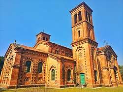 St Stephen's Church, Bareilly Cantt | |
 Bareilly Cantonment Location in Uttar Pradesh, India | |
| Coordinates: 28.364°N 79.415°E | |
| Country | |
| State | Uttar Pradesh |
| District | Bareilly district |
| Founded by | British Indian Army |
| Government | |
| • Type | Municipal |
| • Body | Indian Army |
| Area | |
| • Total | 17.12 km2 (6.61 sq mi) |
| Population (2011) | |
| • Total | 30,003 |
| • Density | 1,800/km2 (4,500/sq mi) |
| Languages | |
| • Official | Hindi, Urdu |
| Time zone | UTC+5:30 (IST) |
| Vehicle registration | UP 25 |
| Website | cbbareilly |
History
The city of Bareilly, along with the entire Rohilkhand region, came under the suzerainty of the East India Company in 1801. The Bareilly Cantonment was established in 1811.[1] A small fort was constructed to the south of the city, and a few years later, the cantonment area contained much more buildings in than the entire city.[2]
The city of Bareilly played a major role in the Indian Rebellion of 1857, and as a result, the cantonment saw major damages. When Bareilly was recaptured by the British in 1858, regular British troops were deployed in the cantonment area.[3] The cantonment was then mainly divided into three parts; The Indian Infantry lines were in the eastern part, British Infantry lines and an Indian battalion were in the middle part, while the Artillery lines were stationed in the western part of the cantonment.[3]
Geography
The Bareilly Cantonment is spread over an area of 17.12 square kilometres (6.61 sq mi).[4] It is surrounded on all sides by Bareilly city and is located to the south of the city centre. The neighbourhood of Civil Lines lies to its north, Kandharpur, Chanehti and Thiriya Nizamat Khan to its south and Nakatiya and Bhartaul lie to its west while the Railway Line separates it from the neighborhood of Subhash Nagar on the east. Several green areas are located in the Cantonment including the Phool Bagh Garden and The Armyy Ecological Park & Training Area (AEPTA), which also houses a Golf course.
Demographics
| Historical population | ||
|---|---|---|
| Year | Pop. | ±% |
| 1931 | 9,852 | — |
| 1941 | 12,162 | +23.4% |
| 1951 | 13,404 | +10.2% |
| 1961 | 13,205 | −1.5% |
| 1971 | 18,270 | +38.4% |
| 1981 | 25,957 | +42.1% |
| 1991 | 26,689 | +2.8% |
| 2001 | 28,038 | +5.1% |
| 2011 | 30,003 | +7.0% |
| Source: District Census Handbook Bareilly[4] | ||
As of 2011 India census,[4] Bareilly Cantonment had a population of 30,003. Males constitute 59.1% of the population and females 40.9%.[5] Bareilly Cantonment has an average literacy rate of 87.91%, higher than the national average of 59.5%; with 92.54% of the males and 81.09% of females literate. 10.45% of the population is under 6 years of age.
Major Units / Formations
- Jat Regimental Centre (JRC)
- Headquarters Uttar Bharat Area
- Headquarters 6 Mountain Division
- Junior Leaders Academy (JLA)
Transport

The Bareilly Cantonment is located at a distance of 250 kilometres (160 mi) from Delhi and Lucknow, 220 kilometres (140 mi) from Agra and 145 kilometres (90 mi) from Nainital. The Bareilly Junction railway station (station code: BE) is located near the western limits of the Cantonment, while the Chanehti Railway Station (station code: CHTI) is located to its south. The Cantonment sometimes lends its name to the Chanehti station, which is also called the Bareilly Cantt Station. The Bareilly Satellite bus station is located near the eastern limits of the Cantonment.
References
- "UP elections 2017: Six Cantonment Assembly seats become force to reckon with". News Nation English. Retrieved 6 May 2020.
- Lal, Hira (1987). City and Urban Fringe: A Case Study of Bareilly. Concept Publishing Company. ISBN 978-81-7022-190-6. Retrieved 18 February 2020.CS1 maint: ref=harv (link)
- Kudaisya, Gyanesh (2006). Region, Nation, "Heartland": Uttar Pradesh in India's Body Politic. SAGE Publishing India. ISBN 978-93-5280-542-6. Retrieved 7 February 2020.
- District Census Handbook Bareilly Part-A (PDF). Lucknow: Directorate of Census Operations, Uttar Pradesh. p. 692.
- "Bareilly Cantonment (Bareilly, Uttar Pradesh, India) - Population Statistics, Charts, Map, Location, Weather and Web Information". www.citypopulation.de. Retrieved 6 May 2020.