Nainital
Nainital (IPA: [nɛːniːtaːl] (![]()
Nainital | |
|---|---|
Town | |
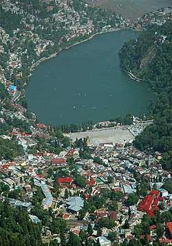 View from Nainital lake | |
| Nickname(s): Sarovar Nagari (Lake city) | |
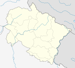 Nainital Location in Uttarakhand, India  Nainital Nainital (India) | |
| Coordinates: 29.395°N 79.449°E | |
| Country | India |
| State | Uttarakhand |
| District | Nainital |
| Area | |
| • Total | 11.73 km2 (4.53 sq mi) |
| Elevation | 2,084 m (6,837 ft) |
| Population (2011) | |
| • Total | 41,377 |
| • Density | 3,500/km2 (9,100/sq mi) |
| Languages | |
| • Official | Hindi[2] |
| • Native | Kumaoni |
| Time zone | UTC+5:30 (IST) |
| PIN | 263001/263002 |
| Telephone code | +91 - 5942 |
| Vehicle registration | UK-04 |
| Website | nainital |
Nainital is located in the Kumaon foothills of the outer Himalayas at a distance of 285 km (177 mi) from the state capital Dehradun and 345 km (214 mi) from New Delhi, the capital of India. Situated at an altitude of 2,084 metres (6,837 ft) above sea level, the city is set in a valley containing an eye-shaped lake, approximately two miles in circumference, and surrounded by mountains, of which the highest are Naina Peak (2,615 m (8,579 ft)) on the north, Deopatha (2,438 m (7,999 ft)) on the west, and Ayarpatha (2,278 m (7,474 ft)) on the south. From the tops of the higher peaks, "magnificent views can be obtained of the vast plain to the south, or of the mass of tangled ridges lying north, bound by the great snowy range which forms the central axis of the Himalayas."[3] The hill station attracts tourists round the year.
Geography and climate
Topography
The city of Nainital covers a total area of 11.73 km2 (4.53 sq mi), and is located at 29.38°N 79.45°E,[4] at an average elevation of 2,084 metres (6,837 ft) above sea level. The slopes of the nearby mountains are most populated, with an elevation ranging from 1,940–2,100 m (6,360–6,890 ft). The highest point nearby is the Naina Peak, with an elevation of 2,619 m (8,593 ft). The city is located in the Kumaon foothills of the outer Himalayas at a distance of 285 km (177 mi) from the state capital Dehradun and 345 km (214 mi) from New Delhi, the capital of India.

The city is set in a valley around the Nainital Lake - an eye-shaped lake, which is located at an altitude of 1,940 m (6,350 ft) from sea level. The lake is 1,433 m (1,567 yd) long and 463 m (506 yd) wide, and is approximately two miles in circumference.[5] The bed of the lake is at a depth of 85 m (93 yd) near Pashandevi, the deepest point of the lake. The lake is deduced to have been formed tectonically. Balia Nala, which is the main stream feeding the lake is along a fault line and the subsequent streams align parallel to major joints and faults. 26 major drains feed the lake including the 3 perennial drains.
Nainital is surrounded by the mountains of Ayarpata (2,344 m (7,689 ft)), Devpata (2,435 m (7,989 ft)), Hanibani (2,180 m (7,153 ft)), China (2,612 m (8,568 ft)), Alma (2,430 m (7,980 ft)), Ladiya Kanta (2,482 m (8,144 ft)) and Sher ka Danda (2,398 m (7,869 ft)).[5]
Geology
The Krol group of rocks, comprising slates, marls, sandstones, limestones and dolomites with a few small dykes intrusives, is the dominant geological formation of Nainital's surroundings, although, Nodules, laminae and stringers of phosphatic material, followed upward by the purple green shales intercalated with muddy finegrained sandstone and siltstone; recognised as the Tal Formation; are also prevalent. The region has a complex geological framework; the rocks are fragile and newly formed. The city is completely located in the catchment area of the Nainital lake, which has highly folded and faulted rocks due to poly phase deformation.
Landslides are a frequent occurrence in the hill slopes surrounding the lake, which are steep. The slopes are highly vulnerable to landslides and mass movement due to various geological and human factors. The first known landslip occurred in Nainital in 1866 on Alma hill, and in 1879 there was a larger one at the same spot. The greatest landslide in Nainital occurred on 18 September 1880, on the slope which rising from the north of the flats ends at Alma peak, and resulted in 151 people being buried under the debris.[6] Another heavy landslip occurred on 17 August 1898 outside the Nainital valley.[7]
Climate
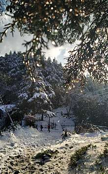
Nainital experiences subtropical highland climate (Cwb) according to Köppen–Geiger climate classification system as the city's climate is influenced by the elevation. The city is a bit dry during winter and very wet during summer due to South Asian monsoon system. The lowest precipitation total occurs in November with total 7.9 millimetres (0.31 in), while the highest precipitation total occurs in July with total 725 millimetres (28.5 in). Like most places in temperate region, Nainital has relative cool summer. The hottest month is July with temperature ranging from 16.4 °C (61.5 °F) to 23.5 °C (74.3 °F), while the coldest month is January with temperature ranging from 1.7 °C (35.1 °F) to 10.7 °C (51.3 °F). The highest Temperature ever recorded in Nainital was 30 °C (86 °F) recorded on 18 June 1972, while the lowest temperature was −5.6 °C (21.9 °F) recorded on 17 January 1953.[8]
The winter season in Nainital commences by mid November, and lasts till mid-March. Temperature gradually declines from the month of November onwards and January is the coldest month. Frost and mist are common features in the months of December and January. Occasionally widespread rainfall also occurs due to western disturbance, with snow occurring on peaks higher than 2000m. The winter rainfall is sometimes associated with the cyclonic activities. The temperature, however, shows an increasing trend by the end of February or the first half of March. By mid-March, there is a progressive rise in temperature, which indicates the onset of summer season. While days get slightly warmer; the nights continue to be cool. There is a constant increase in temperature during May and early June, when the highest temperature is recorded. The months of March and April are also associated with the occurrence of hailstorms, which brings a short spell of cold.
The onset of the summer in the hills is relatively earlier than the plains and is also very lengthy and humid. The mean temperature in July and August goes down and humidity rises abruptly during this season. The monsoon usually begins by mid-May when the rain strikes and continue until mid-October. Nainital, due to its proximity to the outermost high ranges of the Himalaya, receives a high annual rainfall. Generally, by mid-September, the monsoon gets weakened and rain occurs generally after long intervals. With the retreat of the monsoon the winds blow in a reverse direction. The weather during the post-monsoon months is characterised with bright skies. It is in fact a transition between the rains and the winters and with reduced rainfall, the monthly temperature records a progressive decline till mid-January.
| Climate data for Nainital (1961-1979, extremes 1953–1979) | |||||||||||||
|---|---|---|---|---|---|---|---|---|---|---|---|---|---|
| Month | Jan | Feb | Mar | Apr | May | Jun | Jul | Aug | Sep | Oct | Nov | Dec | Year |
| Record high °C (°F) | 18.4 (65.1) |
21.7 (71.1) |
24.6 (76.3) |
28.0 (82.4) |
29.6 (85.3) |
30.0 (86.0) |
26.1 (79.0) |
26.6 (79.9) |
24.6 (76.3) |
24.8 (76.6) |
21.4 (70.5) |
21.8 (71.2) |
30.0 (86.0) |
| Average high °C (°F) | 10.9 (51.6) |
11.9 (53.4) |
16.1 (61.0) |
20.7 (69.3) |
23.2 (73.8) |
23.4 (74.1) |
21.7 (71.1) |
21.0 (69.8) |
20.5 (68.9) |
18.8 (65.8) |
15.3 (59.5) |
12.8 (55.0) |
18.0 (64.4) |
| Average low °C (°F) | 1.7 (35.1) |
3.3 (37.9) |
7.3 (45.1) |
11.8 (53.2) |
14.3 (57.7) |
16.2 (61.2) |
16.3 (61.3) |
16.0 (60.8) |
13.7 (56.7) |
9.7 (49.5) |
5.8 (42.4) |
2.9 (37.2) |
9.9 (49.8) |
| Record low °C (°F) | −5.6 (21.9) |
−4.3 (24.3) |
−3.0 (26.6) |
0.0 (32.0) |
5.0 (41.0) |
10.0 (50.0) |
10.4 (50.7) |
9.6 (49.3) |
−1.1 (30.0) |
4.4 (39.9) |
0.5 (32.9) |
−4.4 (24.1) |
−5.6 (21.9) |
| Average rainfall mm (inches) | 82.4 (3.24) |
66.1 (2.60) |
57.1 (2.25) |
33.8 (1.33) |
72.4 (2.85) |
339.1 (13.35) |
685.4 (26.98) |
556.4 (21.91) |
346.3 (13.63) |
54.7 (2.15) |
7.7 (0.30) |
23.9 (0.94) |
2,305.3 (90.76) |
| Average rainy days | 3.5 | 3.9 | 3.5 | 2.8 | 4.7 | 12.8 | 20.4 | 19.8 | 11.1 | 2.8 | 0.5 | 1.4 | 87.2 |
| Average relative humidity (%) (at 17:30 IST) | 65 | 60 | 53 | 49 | 48 | 66 | 82 | 84 | 79 | 65 | 62 | 59 | 64 |
| Source: India Meteorological Department[9][8] | |||||||||||||
Flora and Fauna
The areas around Nainital (in the middle Himalayan ranges up to 2,000 m (6,600 ft), a temperate zone), is rich in flora (typical temperate climate plants) and fauna.[10] The trees and bushes grown in the region (lake's basin) with their botanical and common Indian names (in parenthesis) are : Quercus incana Oak (Banj), Aesculus indica (Pangar or Horse chestnuts), Juglans regia (Akhrot or walnut), Populus ciliata (Hill Pipal, a sacred tree), Fraxinus micrantha (Ash tree or Angu), Platanus orientalis (Chinar), Rubus lasiocarpus (Hisalu), Rosa moschata (Kunj or Musk rose), Berberis asiatica (Kilmora), Cupressus torulosa (Surai or Himalayan cypress), Rhododendron arboreum (Buruns), Cedrus deodara (Deodar), Salix acmophylla (Weeping Willow), and Pinus (Pine).[10]
Several species of medicinal flora and horticulture plants have also been found in the lake. The Aquatic Macrophytic vegetation include Potamogeton pectinatus, Potamogeton crispus, Polygonum glabrum, Polygonum amphibium and Polygonum hydropiper (Water pepper).[10] The fishes found in the lake are generally carps Mahseer, and the mirror carp which breed several times during one spawning season during May to September. Two species of Mahaseer fish viz., Tor tor: The red finned mahseer and the Tor putitora: The yellow finned mahseer, a food fish which grows to varying sizes from 20 to 60 cm (7.87 to 23.62 inches) are found. Three species of Hill Trout are found in the lake: the Schizothorax sinuatus, Schizothorax richardsoni and Schizothorax plagiostornus. The imported fish bred in the lake is Mirror carp or Cyprinus carpio.[10] Gambusia affinis also called Mosquitofish has been introduced in the lake as a biocontrol measure to control Mosquito larvae.[10]
Demographics
| Historical population | |||
|---|---|---|---|
| Census | Population | %± | |
| 1881 | 6,576 | — | |
| 1891 | 8,455 | 28.6% | |
| 1901 | 7,609 | −10.0% | |
| 1911 | 10,270 | 35.0% | |
| 1921 | 11,230 | 9.3% | |
| 1931 | 9,741 | −13.3% | |
| 1941 | 9,539 | −2.1% | |
| 1951 | 12,350 | 29.5% | |
| 1961 | 14,495 | 17.4% | |
| 1971 | 23,986 | 65.5% | |
| 1981 | 24,835 | 3.5% | |
| 1991 | 29,837 | 20.1% | |
| 2001 | 38,630 | 29.5% | |
| 2011 | 41,377 | 7.1% | |
| Source: 1881 – The Imperial Gazetteer of India[11]:82 1901–2011 – District Census Handbook: Nainital[1]:509–510 | |||

As of the 2011 Indian census, Nainital had a population of 41,377.[12] Males constitute 52.3% of the population and females 47.7%, which gives the city a sex ratio of 911 women per every 1000 men, which is less than the Uttarakhand state average of 963 women per every 1000 men. The population density was 3527.45 people per square km.[1] There were 9,329 housing units in the city at an average density of 795.31 households per square km.[1] 9.54% of the population is under 6 years of age. In 2011, Nainital had an average literacy rate of 92.93%, higher than the Uttarakhand state average of 78.82% - around 96.09% males and 89.47% females in the city are literate.[12]
A special Census taken in September 1880, at the height of the tourism season, returned a total population of 10,054 for the city.[11] However, the official Census in February 1881 returned the population, then at its lowest, at 6,576. The population slightly rose in the following decade, rising to 8,455 in 1891. After dropping to 7,609 in 1901, it remained steady in the coming two decades; 10,270 in 1911 and 11,230 in 1921. The population took another drop, when the 1931 and 1941 censuses returned a population of 9,741 and 9,539 respectively, but has seen a continuous rise since then, with subsequent census reports returning a population of 12350 in 1951, 14495 in 1961, 23986 in 1971, 24835 in 1981, 29837 in 1991, 38630 in 2001, and 41377 in 2011.
Hinduism is the largest religion in Nainital, with 85.61% of residents identifying as Hindus in the 2011 Census. The city's religious profile is highly diverse, Nainital has a significant number of people from Muslim, Sikh and Christian communities. Islam is second most popular religion in city of Nainital with approximately 11.91% following it. Christianity is followed by 0.92%, Jainism by 0.01%, Sikhism by 0.75% and Buddhism by 0.77%. Approximately 0.02% of the population were either atheists or followed 'no particular religion'. Nainital in 1880 had a population of 10,054, which consisted of 6,862 Hindus, 1,748 Muslims, 1,348 Europeans, 34 Eurasians, 57 Native Christians and 5 ‘others’.[11] Native Kumaonis form the major part of the town's population along with people from all over India.
Mythology

It is believed that the Naini Lake is one of the 51 Shakti Peeths, or The most popular is based on the story of the death of the goddess Sati. Out of grief and sorrow, Shiva carried Sati's body, reminiscing about their moments as a couple, and roamed around the universe with it. Vishnu had cut her body into 52 body parts, using his Sudarshana Chakra, which fell on Earth to become sacred sites where all the people can pay homage to the Goddess. The spot where Sati's eyes (or Nain) fell, came to be called Nain-tal or lake of the eye. The goddess Shakti is worshiped at the Naina Devi Temple, known by locals as Naini Mata Temple on the north shore of the present day lake.[13]
History
Early construction
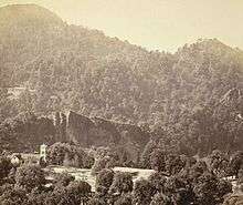
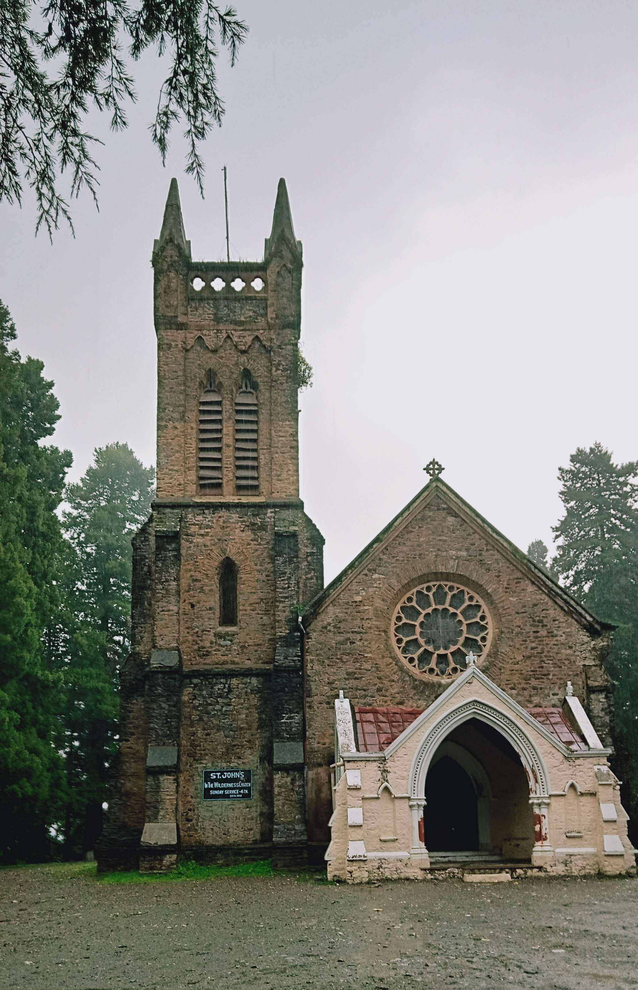
The Kumaon Hills came under British rule after the Anglo-Nepalese War (1814–16). The hill station town of Naini Tal was founded only in 1841, with the construction of the first European house (Pilgrim Lodge) by P. Barron, a sugar trader from Shahjahanpur. In his memoir, he wrote: "It is by far the best site I have witnessed in the course of a 1,500 miles (2,400 km) trek in the Himalayas."[14] In 1846, when a Captain Madden of the Bengal Artillery visited Naini Tal, he recorded that "houses were rapidly springing up in most parts of the settlement: some towards the crest of the military ranges were nearly 7,500 ft (2,300 m) above sea level: the rugged and woody Anyarpatta Aashish (Anyar-patt – in Kumaoni means – complete blackout. The reason for this nomenclature by the locals was because there were minimal sun rays due to its location and dense forests) was being gradually planted and that the favourite sites were on the undulating tract of forest land which stretched back from the head of the lake to the base of China and Deopatta (Camel's Hump). The church, St. John(1846) in the Wilderness, was one of the earliest buildings in Nainital, followed by Belvedere, Alma lodge, Ashdale Cottage(1860)..."[15] Soon, the town became a health resort favoured by British soldiers and by colonial officials and their families trying to escape the heat of the plains. Later, the town became the summer residence of the governor of the United Provinces.
The landslip of 1880


On 18 September 1880 a landslide ('the landslip of 1880') occurred at the north end of the town, burying 151 people. The first known landslide had occurred in 1866(old Victoria hotel was destroyed), and in 1869 there was a larger one at the same spot, Alma Hill, but "the great slip" occurred on "Saturday 18 September 1880."[15]
"During Friday(17th) and Saturday(18th), 33 inches of rain fell, of which 20 inches (510 mm) to 25 in (640 mm) fell during the 40 hours preceding Saturday evening, and the downpour still lasted and continued till the evening of the next day. This heavy fall made the whole hillside one mass of semi-fluid matter, and required little to set in motion. The motive power was a shock of a minor earthquake, which was felt on that day itself by competent observers in the Bhabar below and Nainital itself. On the site of the Slip was the Victoria Hotel and its offices, and below it was the hindu temple of "naina devi" and the Assembly Rooms, both by the side of the lake, and Bell's shop, which was close to the temple. Initial slip started around 10 am of 18 September, taking away western wing of the Victoria Hotel and portion of the hotel's out-houses. Tragically, most of the people were not moved much further away from the spot of the morning slip. At quarter to two the major landslip occurred and within few seconds all the buildings mentioned above were destroyed and made into an unrecognizable heap of rubble and much of it was swept into the lake."[15][16]
The number of dead and missing were 108 Indian and 43 Europeans, along with numerous people who narrowly escaped. (See poem by Hannah Battersby on the page Literary references to Nainital.) The Assembly Rooms and the Naina Devi Temple were destroyed in the disaster. A recreation area known as 'The Flats' was later built on the site and a new temple was erected. To prevent further disasters, storm water drains were constructed and building bylaws were made stricter.
Government and Politics
Civic Administration
The municipal board of Nainital had its origin in 1845, when the provisions of the Act I of 1842 were sanctioned by the government in the town, which then applied to approximately two thirds of the total population.[17]:90
Politics
Nainital city is represented in the Lok Sabha, the lower house of the Indian Parliament, by a representative elected from the Nainital-Udhamsingh Nagar Constituency. Ajay Bhatt, from BJP, is the current Member of Parliament from Nainital-Udhamsingh Nagar.[18] He won the 2019 Indian general elections by 3,39,096 votes against Harish Rawat from the Congress, who was also the former chief minister of the state.[19] Prior to the delimitation of the Loksabha Constituencies of Uttarakhand in 2008, the city was a part of the Nainital Lok Sabha constituency.[20] Generally considered a Congress Stronghold, the Congress has registered a victory from Nainital eight times since 1951.[21] While the BJP has won this seat three times, several other political parties have also managed three victories.
Education
.jpg)
In the latter half of the 19th century a number of "European" schools for boys and girls were founded in Nainital. During the Victorian and Edwardian eras, students in these schools consisted largely of children of the British colonial officials or soldiers. The Diocesan Girls' High School, now known as All Saints' College, was established in 1869, near where the High Court of Uttarakhand stands today. By 1906, there were over half a dozen such schools,[15] including the Diocesan Boys' School (later renamed Sherwood College) and the Philander Smith's college (later renamed Halett War School, currently Birla Vidya Mandir).
St. Joseph's College, Nainital (popularly known as SEM), a day-boarding and residential school built by Irish brothers[22] in 1888, celebrated its 125th anniversary in 2013. Another important school for girls, St. Mary's Convent High School, Nainital(popularly known as Ramnee), was established in 1878, and celebrated its 125th anniversary in year 2003.
Transport

Nainital can be reached by the National Highway 109 (previously National Highway 87) from Haldwani,[23] 40 km (25 mi) away, or by State Highway 13 from Bajpur,[24] 60 km (37 mi) away. The nearest airport is in Pantnagar near Rudrapur, about 71 km (44 mi) from Nainital.[25] Alliance Air, Air Heritage and Deccan Charters are the three carriers, that connect the airport to Delhi, Dehradun and Pithoragarh.[26][27][28] The closest major railway station is Kathgodam, on the outskirts of Haldwani, which is connected with almost all major cities of the country.[29]
Places of interest
A popular hill station, Nainital has numerous tourist spots including Nainital Lake, Naina Peak 8622ft, Himalaya Darshan & Echo Zone, Hanumangarhi and Pt. G.B. Pant High Altitude Zoo, Nainital.
Jama Masjid
The building of Jama Masjid located in Mallital area of Nainital is a mosque which was built by the British in the late 19th century for their Muslim soldiers.[30][31]
Naina Devi Temple
Temple of Naina Devi is located at the upper end of the beautiful Naini lake. This temple is dedicated to the goddess of the town Naina Devi. Its complex becomes the location of the famous Nanda Devi Mela festival which held every year on Nandashtami during September.[32]
St John Wilderness Church
St. John in the Wilderness is one of the oldest and finest churches in Nainital. The Church is dedicated to St. John the Baptist. This Anglican Church was built in 1846 and is one of the earliest buildings erected in Nainital.[33]
Libraries
There are a number of libraries in the Nainital area. Among them are the Durga Lal Shah Municipal Public Library on the Mall, founded in 1934,[34] the Uttarakhand Academy of Administration, Library and Documentation Center, Mallital,[35] the ARIES Observatory Library,[36] and the Kumaon University Library, Nainital.[37]
Notable people
- Amitabh Bachchan, Bollywood actor. Educated at Sherwood College.
- Sonam Bajwa, Indian actress.
- Kabir Bedi, Bollywood Actor. Educated at Sherwood College.
- Jim Corbett, hunter of man-eating tigers, author, conservationist and namesake of Jim Corbett National Park. Educated at St. Joseph's College.
- Danny Denzongpa, Bollywood actor studied in Birla Vidya Mandir
- Percy Hobart, British major general and military engineer
- Elsie Inglis, physician and social reformer
- Hastings Ismay, 1st Baron Ismay, first secretary general of NATO
- Anup Jalota, singer
- Sukirti Kandpal, TV actress
- Sudhir Kakar, renowned psychoanalyst
- Field Marshal Sam Manekshaw, Indian Army Chief of Staff during Indo-Pakistani War of 1971. Educated at Sherwood College.
- Eric Maturin, British actor
- Lalit Modi, Indian Premier League (IPL) chairman. Educated at St. Joseph's College.
- Rajendra K. Pachauri, chairman of the Intergovernmental Panel on Climate Change
- Manish Pandey, cricketer who plays for Karnataka and Bangalore
- Nirmal Pandey, Bollywood actor and singer
- Ram Kapoor, TV actor. Educated at Sherwood College.
- Govind Ballabh Pant, statesman and leader of India's independence movement, first Indian Premier of British India, the first Chief Minister of Uttar Pradesh and the third Home Minister of India
- Krishna Chandra Pant, former Deputy Chairman of the Planning Commission of India. Educated at St. Joseph's College.
- Naseeruddin Shah, Bollywood actor. Educated at St. Joseph's College.
- Major Som Nath Sharma, India's first Param Vir Chakra award winner. Educated at Sherwood College.
- Shivani, Hindi poet
- Billy Arjan Singh, Tiger Conservationist of India, Educated in Nainital.[38]
- Dilip Tahil, Bollywood actor. Educated at Sherwood College.
- Narayan Dutt Tiwari, Indian leader and politician, former Governor of Andhra Pradesh, former Chief Minister of Uttarakhand and Uttar Pradesh, and former Finance Minister of India.
- Orde Charles Wingate, British general and commander of the Chindits in Burma during World War II
Gallery
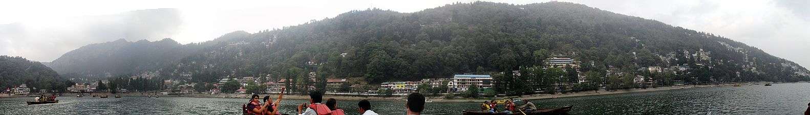 Panoramic view of Nainital from Naini Lake
 Nainital overview
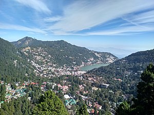 Nainital Hills
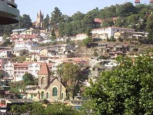 Urban Areas
 The Mall Road, 2006.
 Ramlila Bhawan, Mallital, Nainital.
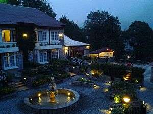 A view from Hotel Naini Retreat's Balcony.
.jpg) Naini Lake after snowfall (2007)
Naini Lake after snowfall (2007)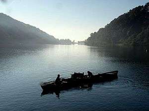 Nainital lake in the morning
 Nainital in May 2011
 Yachts in Naini Lake in March 2011
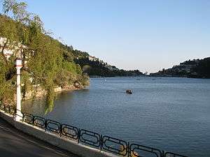 Nainital Lake in 2009.
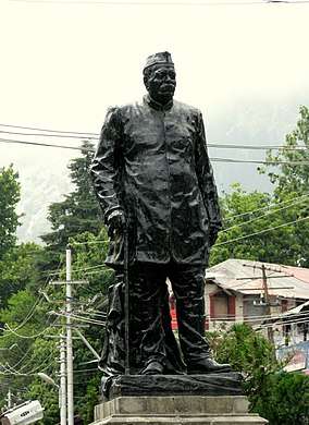 Statue of Govind Ballabh Pant, at Mall Road, Nainital.
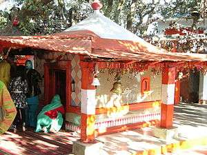 Golu Devta temple, at Ghorakhal near Nainital.
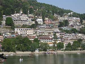 Naini Lake
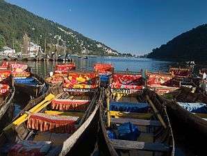 Boats on the Lake.
 Gurney House-the home of Jim Corbett
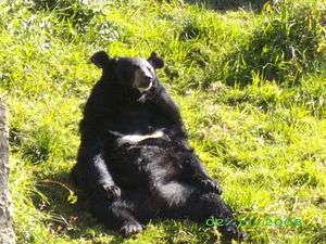
- A Bear in the Pt. G B Pant High Altitude Zoo, Nainital.
 Naina Devi Temple, after which the place gets its name.
See also
References
- District Census Handbook Nainital Part-A (PDF). Dehradun: Directorate of Census Operations, Uttarakhand.
- "52nd REPORT OF THE COMMISSIONER FOR LINGUISTIC MINORITIES IN INDIA" (PDF). nclm.nic.in. Ministry of Minority Affairs. p. 18. Archived from the original (PDF) on 25 May 2017. Retrieved 22 December 2018.
- Nainital District, The Imperial Gazetteer of India, volume 18, pp. 322–323. 1908
- Falling Rain Genomics, Inc – Nainital. Fallingrain.com.
- Pande 1993, p. 32
- Murphy 1906, p. 37
- Murphy 1906, p. 42
- "Extremes of Temperature & Rainfall for Indian Stations (Up to 2012)" (PDF). India Meteorological Department. December 2016. p. M227. Archived from the original (PDF) on 5 February 2020. Retrieved 31 March 2020.
- "Station: Nainital Climatological Table 1961–1990" (PDF). Climatological Normals 1961–1990. India Meteorological Department. July 2010. pp. 581–582. Archived (PDF) from the original on 16 February 2020. Retrieved 31 March 2020.
- "Introduction, Horticulture, Medicinal flora, Animals and Fishes". Archived from the original on 7 April 2008. Retrieved 29 January 2020.
- Hunter, W. W. (1886). The Imperial Gazetteer of India Volume VIII. London: Trubner & Co.
- Nainital Population Census 2011.
- View of Mallital, without the presend Naina Devi Temple (1865) British Library.
- (Pilgrim 1844)
- (Murphy 1906)
- CLAY, J.M. (2010). NAINITAL: A Historical and Descriptive Account. Talla danda, Tallital, NAINITAL: PAHAR. pp. 17, 18, 19. ISBN 978-81-86246-52-8.
- Shah, Giriraja (1999). Nainital: The Land of Trumpet and Song ; Based on J.M. Clay's Book on Nainital. Abhinav Publications. ISBN 978-81-7017-324-3. Retrieved 17 April 2020.
- "Kumaon Division: Member Of Parliaments". kumaon.gov.in. Retrieved 16 April 2020.
- Sharma, Nihi (24 May 2019). "Lok Sabha Elections Results 2019: Former CM Harish Rawat loses in Naintal by over 3 lakh votes". Hindustan Times. Dehradun. Retrieved 16 April 2020.
- "Delimitation of Parliamentary & Assembly Constituencies Order - 2008". Election Commission of India. Retrieved 16 April 2020.
- Dewan, Umesh (13 April 2009). "Three in fray, but bipolar contest expected: Nainital-Udham Singh Nagar Seat". The Tribune. Retrieved 31 December 2009.
- "History". www.stjosephscollege.in. Retrieved 10 October 2019.
- "Landslide spoils festivity, NH-87 blocked". Nainital: The Times of India. TNN. 17 August 2016. Retrieved 30 November 2016.
- "वर्ष 2016-17 में लोक निर्माण विभाग के अंतर्गत राज्य मार्ग की लम्बाई" (PDF). Retrieved 29 January 2020.
- "A gem in perfect setting". The Tribune. 11 May 2008. Retrieved 29 June 2009.
- "Alliance Air to start flights on Pantnagar-Dehradun route from Jan 4". The Economic Times. 28 December 2018. Retrieved 29 January 2020.
- "Comprehensive list of Awarded RCS Routes state wise" (PDF). Airport Authority of India. Retrieved 5 March 2019.
- "flight schedule of Air Deccan". Archived from the original on 12 June 2018. Retrieved 29 January 2020.
- Kishore, B.R. (2008). India : a travel guide. New Delhi: Fusion Books. p. 278. ISBN 9788128400674. Retrieved 11 January 2017. "NAINITAL; Railway Station : Kathgodam 35 kms"
- "Jama Masjid Nainital". Retrieved 23 February 2020.
- Bedi, Aneesha (16 November 2019). "Jama Masjid, Mecca Masjid — why Twitter is flooded with images of India's stunning mosques". ThePrint. Retrieved 24 February 2020.
- "Nainital: Places To Visit". OK Uttarakhand. 28 March 2020.
- https://www.trawell.in/uttarakhand/nainital/st-john-wilderness-church
- Singh, Sarina (2005). Lonely Planet: India (Nainital). ISBN 1-74059-694-3. Page 425.
- The World Bank India: Depository Libraries, 2006.
- "Astronomical Networking Libraries". Archived from the original on 17 July 2006. Retrieved 29 January 2020.
- "Kumaon University". Archived from the original on 5 February 2010. Retrieved 12 April 2020.
- https://sikhchic.com/people/_billy_arjan_singh_honorary_tiger
Further reading
- Bateman, Josiah (1860), The Life of The Right Rev. Daniel Wilson, D.D., Late Lord Bishop of Calcutta and Metropolitan of India, Volume II, John Murray, Albemarle Street, London.
- Corbett, SAYUJ (2002) [2000], Inter H.G.S – Indian Culture in Daily Life., Oxford India Reprint
- Corbett, Jim (2002) [1948], The Man Eating Leopard of Rudraprayag, Oxford India Reprint
- Corbett, Jim (2002) [1954], The Temple Tigers and More Man-Eaters of Kumaon, Oxford India Reprint
- Fayrer, Joseph (1900), Recollections of my life, William Blackwood and Sons, Edinburgh and London
- Imperial Gazetteer of India, Volume 18, pp. 322–323., Oxford University Press, Oxford and London, 1908
- Kennedy, Dane (1996), The Magic Mountains: Hill Stations and the British Raj, University of California Press, Berkeley, Los Angeles, and Oxford. 264 pages.
- Kipling, Rudyard (1889), The Story of the Gadsbys, Macmillan and Company, London
- Kipling, Rudyard (1895), Under the Deodars, Macmillan and Company, London
- McLaren, Eva Shaw (1920), Elsie Inglis: The Woman with the Torch, Macmillan and Company, New York
- M'Crindle, J.W. (1901), Ancient India: As Described in Classical Literature, Archibald ConstaHble & Company, Westminster
- Murphy, C.W. (1906), A Guide to Naini Tal and Kumaun, Allahbad, United Provinces
- Notes on Wanderings in the Himmala, containing descriptions of some of the grandest scenery of the snowy range, among others of Naini Tal, Agra Akhbaar Press, Agra
External links
| Wikimedia Commons has media related to Nainital. |
| Wikisource has the text of the 1911 Encyclopædia Britannica article Naini Tal. |
- Official website
