Arabian Plate
| Arabian Plate | |
|---|---|
 | |
| Type | Minor |
| Approximate area | 5,000,000 km2[1] |
| Movement1 | north |
| Speed1 | 15–20 mm/year |
| Features | Arabian Peninsula, Red Sea, Gulf of Aden, Persian Gulf, Indian Ocean |
| 1Relative to the African Plate | |
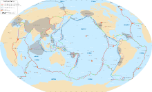
The Arabian Plate is a tectonic plate in the northern and eastern hemispheres.
It is one of three continental plates (the African, Arabian, and Indian Plates) that have been moving northward in recent geological history and colliding with the Eurasian Plate. This is resulting in a mingling of plate pieces and mountain ranges extending in the west from the Pyrenees, crossing Southern Europe to Iran, forming the Alborz and Zagros Mountains, to the Himalayas and ranges of southeast Asia.[2]
Lexicology
The Arabian Plate is the most common designation of the region, although it is also sometimes referred to as the Arab Plate.[3]
Borders
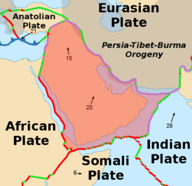
The Arabian Plate consists mostly of the Arabian Peninsula; it extends eastward at the Sinai and the Red Sea and northward to the Levant. The plate borders are:
- East, with the Indian Plate, at the Owen Fracture Zone
- South, with the African Plate to the west and the Somali Plate and the Indian Plate to the east
- West, a left lateral fault boundary with the African Plate called the Dead Sea Transform (DST), and a divergent boundary with the African Plate called the Red Sea Rift which runs the length of the Red Sea;
- North, complex convergent boundary with the Anatolian Plate and Eurasian Plate.[4]
History
The Arabian Plate was part of the African plate during much of the Phanerozoic Eon (Paleozoic–Cenozoic), until the Oligocene Epoch of the Cenozoic Era. Red Sea rifting began in the Eocene, but the separation of Africa and Arabia occurred approximately 25 million years ago in the Oligocene, and since then the Arabian Plate has been slowly moving toward the Eurasian Plate.[5] The opening of the Red Sea rift led to extensive volcanic activity. There are large volcanic fields called the Older Harrats, such as Harrat Khaybar and Harrat Rahat, cover large parts of the western Arabian Plate. Some activity still continues especially around Medina,[6] and there are regular eruptions within the Red Sea.[7]
The collision between the Arabian Plate and Eurasia is pushing up the Zagros Mountains of Iran. Because the Arabian Plate and Eurasian Plate collide, many cities are in danger such as those in southeastern Turkey (which is on the Arabian Plate). These dangers include earthquakes, tsunamis, and volcanoes.
Countries
Countries within the plate include parts of the Iraq, Levant (eastern Lebanon, Syria, and Jordan), the entire Arabian Peninsula (Saudi Arabia, the United Arab Emirates, Oman, Qatar, Bahrain, Kuwait, Yemen), and Djibouti on the Horn of Africa. Regions include parts of the Southern Denkalya Subregion, the Southeastern Anatolia Region, Awdal and the Khuzestan Province.
References
- ↑ "Sizes of Tectonic or Lithospheric Plates". Geology.about.com. 2014-03-05. Retrieved 2016-01-23.
- ↑ Image Science and Analysis Laboratory, NASA-Johnson Space Center. "Tectonics of the Arabian Plate". The Gateway to Astronaut Photography of Earth. NASA. Archived from the original on 6 July 2007. Retrieved 21 July 2007.
- ↑ Unal, Bunyamin, Mucahit Eren, and M. Gurhan Yalcin. "Investigation of leakage at Ataturk dam and hydroelectric power plant by means of hydrometric measurements." Engineering Geology 93.1 (2007): 45-63.
- ↑ arabia2 (2014-09-15). "Plate Boundaries of the Arabian Plate – GEOS 309: Tectonics". Geos309.community.uaf.edu. Archived from the original on 2016-03-04. Retrieved 2016-01-23.
- ↑ "Arabian Plate - African/Arabian Tectonic Plates". Africa-arabia-plate.weebly.com. Retrieved 2016-01-23.
- ↑ "Volcanoes of Saudi Arabia". 2016-03-07. Retrieved 2016-03-24.
- ↑ Wenbin Xu; et al. (2015-05-26). "Birth of two volcanic islands in the southern Red Sea". Nature Communications 6, Article number: 7104.