White Pass (Washington)
| White Pass | |
|---|---|
 U.S. 12 through White Pass | |
| Elevation | 4,500 ft (1,372 m) |
| Traversed by | U.S. Highway 12 |
| Location | Lewis / Yakima counties, Washington, United States |
| Range | Cascades |
| Coordinates | 46°38.3′N 121°23.4′W / 46.6383°N 121.3900°W |


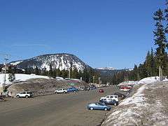
White Pass (elev. 4,500 feet (1,372 m)) is a mountain pass in the northwest United States, located in the Cascade Range of Washington, southeast of Mount Rainier and north of Goat Rocks. U.S. Highway 12 travels over White Pass, connecting Yakima County on the east with Lewis County.
A shortcut route across White Pass between Packwood and Naches was first established 87 years ago as State Road 5 in 1931,[1][2][3] and the link was completed in August 1951 along the current route, later designated U.S. Route 12.
White Pass Ski Area, located at the summit, opened on January 11, 1953. Champion ski racing twins Phil and Steve Mahre (and their seven siblings) grew up on White Pass, where their father Dave Mahre was the mountain manager for the ski area. White Pass is also the home mountain of professional snowboarder Marc Frank Montoya, owner of The Block hotels.
As the crow flies, the pass is approximately 25 miles (40 km) southeast of the summit of Mount Rainier and 30 miles (50 km) north of Mount Adams.
References
- ↑ "Want highway via White Pass". Spokesman-Review. (Spokane, Washington). Associated Press. January 22, 1931. p. 3.
- ↑ "Washington highway map". H.M. Gousha. (David Rumsey Map Collection). 1956. Retrieved January 20, 2017.
- ↑ "State roads as established by legislature (1893–1935)" (PDF). Department of Transportation. (State of Washington). Retrieved January 20, 2017.
External links
- White Pass road conditions
- White Pass Scenic Byway - official site
- Ski White Pass.com - trail map for the ski area
- Experience Washington.com - White Pass Scenic Byway
Coordinates: 46°38.3′N 121°23.4′W / 46.6383°N 121.3900°W
