Tumwater, Washington
| Tumwater, Washington | |
|---|---|
| City | |
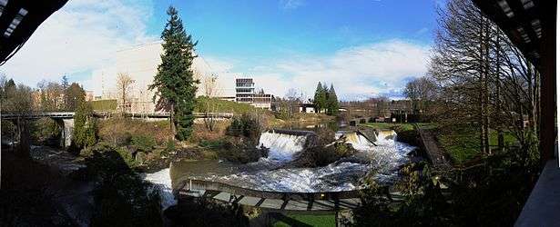 Panoramic view of the upper falls and the former Olympia Brewery, 2011 | |
|
Nickname(s): Washington's First Community | |
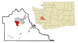 Location of Tumwater, Washington | |
| Coordinates: 47°0′28″N 122°54′40″W / 47.00778°N 122.91111°WCoordinates: 47°0′28″N 122°54′40″W / 47.00778°N 122.91111°W | |
| Country | United States |
| State | Washington (state) |
| County | Thurston |
| Incorporated (town) | November 25, 1869[1] |
| Government | |
| • Type | Mayor-council government |
| • Mayor | Peter N. Kmet |
| • Mayor Pro Tem | Neil McClanahan |
| • City Council |
Michael Althauser Joan Cathey Nicole Hill Tom Oliva Debbie Sullivan Eileen Swarthout |
| Area[2] | |
| • Total | 14.49 sq mi (37.53 km2) |
| • Land | 14.32 sq mi (37.09 km2) |
| • Water | 0.17 sq mi (0.44 km2) |
| Elevation | 174 ft (53 m) |
| Population (2010)[3] | |
| • Total | 17,371 |
| • Estimate (2015)[4] | 19,190 |
| • Density | 1,213.1/sq mi (468.4/km2) |
| Time zone | UTC-8 (Pacific (PST)) |
| • Summer (DST) | UTC-7 (PDT) |
| ZIP codes | 98501, 98511, 98512 |
| Area code | 360 |
| FIPS code | 53-72905 |
| GNIS feature ID | 1512742[5] |
| Website | www.ci.tumwater.wa.us |
Tumwater is a city in Thurston County, Washington, United States. It lies near where the Deschutes River enters Budd Inlet, the southernmost point of Puget Sound. The population was 17,371 at the 2010 census. Thurston County, which includes, among others, the cities of Lacey and Olympia, has a population of 252,264.
History
Tumwater was originally called "New Market", and under the latter name was platted in 1845.[6] The present name is derived from the Chinook language meaning "waterfall".[6] A post office called Tumwater was established in 1863.[7] The city incorporated in 1875.[8]
Geography
Tumwater is located at 47°0′28″N 122°54′40″W / 47.00778°N 122.91111°W (47.007768, -122.911074).[9] The city that borders Tumwater is Olympia.
According to the United States Census Bureau, the city has a total area of 14.49 square miles (37.53 km2), of which, 14.32 square miles (37.09 km2) is land and 0.17 square miles (0.44 km2) is water.[2]
Climate
This region experiences warm and dry summers, with average monthly temperatures between 71.6 °F (22° C) and 98.1 °F (36.7° C). According to the Köppen Climate Classification system, Tumwater has a Very warm-summer Mediterranean climate, abbreviated "Csb" on climate maps.[10]
Demographics
Based on per capita income, one of the more reliable measures of affluence, Tumwater ranks 89th of 522 areas in the state of Washington to be ranked. It is also the highest rank in Thurston County.
| Historical population | |||
|---|---|---|---|
| Census | Pop. | %± | |
| 1870 | 354 | — | |
| 1880 | 171 | −51.7% | |
| 1890 | 410 | 139.8% | |
| 1900 | 270 | −34.1% | |
| 1910 | 490 | 81.5% | |
| 1920 | 472 | −3.7% | |
| 1930 | 793 | 68.0% | |
| 1940 | 955 | 20.4% | |
| 1950 | 2,725 | 185.3% | |
| 1960 | 3,885 | 42.6% | |
| 1970 | 5,373 | 38.3% | |
| 1980 | 6,705 | 24.8% | |
| 1990 | 9,976 | 48.8% | |
| 2000 | 12,698 | 27.3% | |
| 2010 | 17,371 | 36.8% | |
| Est. 2016 | 22,538 | [11] | 29.7% |
| U.S. Decennial Census[12] 2015 Estimate[4] | |||
2010 census
As of the census[3] of 2010, there were 17,371 people, 7,566 households, and 4,460 families residing in the city. The population density was 1,213.1 inhabitants per square mile (468.4/km2). There were 8,064 housing units at an average density of 563.1 per square mile (217.4/km2). The racial makeup of the city was 85.0% White, 1.7% African American, 1.2% Native American, 4.8% Asian, 0.5% Pacific Islander, 1.6% from other races, and 5.2% from two or more races. Hispanic or Latino of any race were 6.2% of the population.
There were 7,566 households of which 28.9% had children under the age of 18 living with them, 40.9% were married couples living together, 13.1% had a female householder with no husband present, 4.9% had a male householder with no wife present, and 41.1% were non-families. 31.6% of all households were made up of individuals and 9.7% had someone living alone who was 65 years of age or older. The average household size was 2.27 and the average family size was 2.83.
The median age in the city was 35 years. 27% of residents were under the age of 18, 10% from 18 to 24; 31.7% were between the ages of 25 and 44; 26.8% from 45 to 64; and 13% were 65 years of age or older. The gender makeup of the city was 47.7% male and 52.3% female.
2000 census
The Washington State Office of Financial Management indicates the 2016 population of the City of Tumwater was 23,040. As of the 2000 census, there were 12,698 people, 5,659 households, and 3,253 families residing in the city. The population density was 1,276.1 people per square mile (492.7/km²). There were 5,953 housing units at an average density of 598.2 per square mile (231.0/km²). The racial makeup of the city was 88.41% White, 1.39% African American, 1.24% Native American, 3.90% Asian, 0.36% Pacific Islander, 1.50% from other races, and 3.21% from two or more races. Hispanic or Latino of any race were 4.08% of the population.
There were 5,659 households out of which 28.3% had children under the age of 18 living with them, 41.5% were married couples living together, 12.3% had a female householder with no husband present, and 42.5% were non-families. 33.7% of all households were made up of individuals and 10.2% had someone living alone who was 65 years of age or older. The average household size was 2.20 and the average family size was 2.82.
In the city, the age distribution of the population shows 23.2% under the age of 18, 10.9% from 18 to 24, 29.5% from 25 to 44, 23.0% from 45 to 64, and 13.5% who were 65 years of age or older. The median age was 36 years. For every 100 females, there were 89.8 males. For every 100 females age 18 and over, there were 84.5 males.
The median income for a household in the city was $43,329, and the median income for a family was $54,156. Males had a median income of $41,778 versus $32,044 for females. The per capita income for the city was $25,080. About 4.3% of families and 8.5% of the population were below the poverty line, including 9.5% of those under age 18 and 5.2% of those age 65 or over.
Government
The Washington State Department of Corrections has its headquarters in Tumwater.[13]
Education
The Tumwater School District is home to Tumwater High School, A.G. West Black Hills High School, Black Lake Elementary School, East Olympia Elementary School, George Washington Bush Middle School, Littlerock Elementary School, Michael T. Simmons Elementary School, New Market Skills Center, Peter G Schmidt Elementary School, Tumwater Hill Elementary School, and Tumwater Middle School.[14]
References
- ↑ "Tumwater History". Archived from the original on 2009-07-30. Retrieved 2009-05-26.
- 1 2 "US Gazetteer files 2010". United States Census Bureau. Archived from the original on 2012-01-24. Retrieved 2012-12-19.
- 1 2 "American FactFinder". United States Census Bureau. Retrieved 2012-12-19.
- 1 2 "Population Estimates". United States Census Bureau. Archived from the original on October 19, 2016. Retrieved June 22, 2016.
- ↑ "US Board on Geographic Names". United States Geological Survey. 2007-10-25. Retrieved 2008-01-31.
- 1 2 "A brief history". City of Tumwater. Retrieved 31 March 2018.
- ↑ "Post Offices". Jim Forte Postal History. Retrieved 31 March 2018.
- ↑ "Thurston County Place Names: A Heritage Guide" (PDF). Thurston County Historical Commission. 1992. p. 90. Retrieved 28 March 2018.
- ↑ "US Gazetteer files: 2010, 2000, and 1990". United States Census Bureau. 2011-02-12. Retrieved 2011-04-23.
- ↑ "Tumwater, Washington Köppen Climate Classification (Weatherbase)".
- ↑ "Population and Housing Unit Estimates". Retrieved June 9, 2017.
- ↑ United States Census Bureau. "Census of Population and Housing". Retrieved October 11, 2013.
- ↑ "Contact Us Archived 2012-12-01 at the Wayback Machine.." Washington State Department of Corrections. Retrieved on December 7, 2009.
- ↑ "Tumwater School District". Archived from the original on 2009-05-25. Retrieved 2009-05-23.
External links
| Wikimedia Commons has media related to Tumwater, Washington. |
- City of Tumwater, Washington (official website)
- Michael T Simmons at Find a Grave
- George Bush at Find a Grave
Municipalities and communities of Thurston County, Washington, United States | ||
|---|---|---|
| Cities | 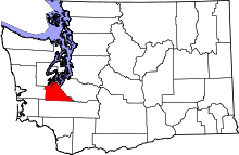 | |
| Town | ||
| CDPs | ||
| Unincorporated communities | ||
| Indian reservation | ||
| Ghost town | ||
| Footnotes | ‡This populated place also has portions in an adjacent county or counties | |
