Trémel
| Trémel Tremael | ||
|---|---|---|
| Commune | ||
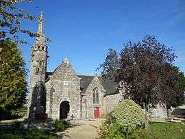 The church of Notre-Dame de la Merci, in Trémel | ||
| ||
 Trémel Location within Brittany region  Trémel | ||
| Coordinates: 48°36′14″N 3°36′37″W / 48.6039°N 3.6103°WCoordinates: 48°36′14″N 3°36′37″W / 48.6039°N 3.6103°W | ||
| Country | France | |
| Region | Brittany | |
| Department | Côtes-d'Armor | |
| Arrondissement | Lannion | |
| Canton | Plestin-les-Grèves | |
| Intercommunality | Lannion Trégor | |
| Government | ||
| • Mayor (2014–2020) | Thérèse Bourhis | |
| Area1 | 11.93 km2 (4.61 sq mi) | |
| Population (2008)2 | 403 | |
| • Density | 34/km2 (87/sq mi) | |
| Time zone | UTC+1 (CET) | |
| • Summer (DST) | UTC+2 (CEST) | |
| INSEE/Postal code | 22366 /22310 | |
| Elevation | 25–155 m (82–509 ft) | |
|
1 French Land Register data, which excludes lakes, ponds, glaciers > 1 km2 (0.386 sq mi or 247 acres) and river estuaries. 2 Population without double counting: residents of multiple communes (e.g., students and military personnel) only counted once. | ||
.svg.png)
Trémel (Breton: Tremael) is a commune in the Côtes-d'Armor department of the region of Brittany in northwestern France.
Population
| Historical population | ||
|---|---|---|
| Year | Pop. | ±% |
| 1962 | 481 | — |
| 1968 | 508 | +5.6% |
| 1975 | 465 | −8.5% |
| 1982 | 446 | −4.1% |
| 1990 | 403 | −9.6% |
| 1999 | 393 | −2.5% |
| 2008 | 403 | +2.5% |
Inhabitants of Trémel are called trémélois in French.
See also
References
External links
| Wikimedia Commons has media related to Trémel. |
- French Ministry of Culture list for Trémel (in French)
| Authority control |
|---|
This article is issued from
Wikipedia.
The text is licensed under Creative Commons - Attribution - Sharealike.
Additional terms may apply for the media files.