Taglang La
| Tanglang La | |
|---|---|
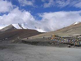 Tanglang La on the Leh-Manali Highway | |
| Elevation | 5,328 m (17,480 ft) |
| Traversed by | Leh-Manali Highway |
| Location | India |
| Range | Himalaya |
| Coordinates | 33°30′28″N 77°46′12″E / 33.50778°N 77.77000°ECoordinates: 33°30′28″N 77°46′12″E / 33.50778°N 77.77000°E |
  | |
Tanglang La, elevation 5,328 metres (17,480 ft), is a high mountain pass in Ladakh region of the Indian state of Jammu and Kashmir. As of August 2014, the Leh-Manali highway leading south from Upshi to Tanglang La is paved, with the exception of a very short (approx 500m) unpaved section just north of the pass. The pass itself is paved. On ascending the pass from Moore plains the road is well paved too with occasional streams crossing.
The elevation in metres, which is taken from a local sign, is in agreement with SRTM data. The sign claims 17,582 feet, which would be 5,358 metres, and claims to be the world’s second highest motorable pass. The claim is no longer accurate however, and is actually the 12th highest motorable pass[1].
Notes
![]()
- ↑ Sharma, Dheeraj (2015-02-05). "Top 13 Highest Motorable Passes or Roads in the World - The Myths & The Realities". Devil On Wheels™. Retrieved 2018-01-31.