Goecha La
| Goecha La | |
|---|---|
 View to the NE (?) from Goecha La. | |
| Elevation | 4,940 m (16,207 ft) |
| Location | India |
| Range | Himalaya |
| Coordinates | 27°36′28″N 88°11′13″E / 27.60778°N 88.18694°ECoordinates: 27°36′28″N 88°11′13″E / 27.60778°N 88.18694°E |
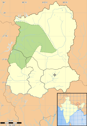 | |
Goecha La (el. 4940 mt or 16,207 ft) is a high mountain pass in Sikkim, India in the Himalaya range.
The southeast face of Mt. Kanchenjunga, the world's third highest mountain, can be viewed from the pass, which is also a base camp for those aspiring to scale the mountain. They say that when the government authorities first saw the view from Goecha La, they were so moved by the view that they decided to feature it on the Rs.100 note.[1]
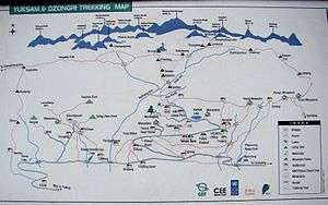
Trekking
Trekking through the Kanchenjunga National Park, in one of the greenest regions in the world, remains one of the top things to do for any holiday maker in the Himalayas. Untouched by any effluence, these forests support a fine ecosystem, with numerous species of unusual flora and fauna. The weather remains clear during the winters and dramatic during the pre-monsoon season, with misty clouds that play around with your imagination. The whole eco-system is maintained in harmony and no single tree stands unaccompanied!
The trek itself can be challenging in terms of distances to be covered in a day. One needs to get properly acclimatized due to the huge changes in altitude over a small time during this trek, which is also another reason for its popularity. However, once you get walking it becomes easy to tackle the challenging distances.
List of Himalayan peaks seen on Goechala Trek from Dzongri Top, Thansing and Goechala: [2]
- Kanchenjunga ( 8586m ),
- Talung ( 7349m ),
- Rathong ( 6679m ),
- Kabru N ( 7353m ),
- Koktang ( 6147m ),
- Simvo ( 6812m ),
- Kabru S ( 7318m ),
- Kabru Dome ( 6600m ),
- Kabru Forked ( 6100m ),
- Pandim ( 6691m ),
- Tenchenkhang ( 6010m ),
- Jupono ( 5650m )
The basic itinerary:
- Drive from SILIGURI TO YUKSOM
- YUKSOM to SACHEN (10 km hike)
- SACHEN to TSHOKA (7 km hike)
- TSHOKA to DZONGRI (10 km hike)
- Rest and hike to DZONGRI LA PASS (4417 m)
- DZONGRI to THANSING (10 km hike)
- THANSING to GOECHA LA PASS and back (14 km hike)
- THANSING to TSHOKA (16 km hike)
- TSHOKA to YUKSOM (17 km hike)
- Drive back to SILIGURI

Film
- Singalila in the Himalaya http://theindia.info/SingaliLaInTheHimalaya Film speaks about the history of Singalila ridge through a 14 day trek.
- Goecha La: In Search of Kangchenjunga