Darcha
| Darcha | |
|---|---|
| village | |
 | |
 Darcha Location in Himachal Pradesh, India  Darcha Darcha (India) | |
| Coordinates: 32°40′26″N 77°12′58″E / 32.674°N 77.216°ECoordinates: 32°40′26″N 77°12′58″E / 32.674°N 77.216°E | |
| Country |
|
| State | Himachal Pradesh |
| District | Lahaul and Spiti |
| Area | |
| • Total | 0.51 km2 (0.20 sq mi) |
| Elevation | 3,360 m (11,020 ft) |
| Population (2001) | |
| • Total | 298 |
| • Density | 580/km2 (1,500/sq mi) |
| Languages | |
| • Official | Hindi |
| Time zone | UTC+5:30 (IST) |
| Vehicle registration | HP |
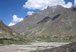
Darcha (elevation 3,360 m or 11,020 ft)[1] is a village on the Bhaga River in Lahaul region in Lahaul and Spiti district in the Indian state of Himachal Pradesh. It is the northernmost permanent settlement in Himachal Pradesh along the Manali-Leh Highway.[2] The Rough Guide to India describes it as "a lonely cluster of dry-stone huts and dingy tent camps".[3]
The village has 65 households and a total population of 298, of which 152 are male and 146 are female.[4] There are 2 residents belonging to scheduled castes and 222 belonging to scheduled tribes.[4] Schooling up to 10+2 is available in the village; there is a Primary Health Centre at Darcha.[4] Drinking water is available, and the village has power and telephone connections.[4]
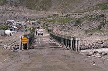
Some buses between Manali and Leh stop for the night at Darcha where travelers sleep in tents. The village is the end-point of a popular trek beginning in Padum, Zanskar. Roadside stalls offer basic food.[2]
All passing vehicles must stop at Darcha's police checkpoint for passport checks.[2][5]
References
| Wikimedia Commons has media related to Darcha. |
- ↑ "Himachal Tourism | Darcha". Archived from the original on 23 September 2009. Retrieved 12 December 2014.
- 1 2 3 Singh, S.; Bindloss, J. (2007). India. Lonely Planet. p. 341. ISBN 9781741043082. Retrieved 2014-12-12.
- ↑ Abram, D. (2003). The Rough Guide to India. Rough Guides. p. 523. ISBN 9781843530893. Retrieved 2014-12-12.
- 1 2 3 4 2001 India Census. See censusindia.gov.in Archived 12 May 2008 at WebCite (registration required). Data aggregated for Darcha Dangma and Darcha Sumdol.
- ↑ Bradnock, R.; Bradnock, R. (2000). Indian Himalaya: The Travel Guide. Footprint Handbooks. p. 196. ISBN 9781900949798. Retrieved 2014-12-12.