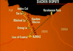
Bilafond La
| Bilafond La | |
|---|---|
 Actual Ground Position Line shown with yellow-colored dotted line | |
| Elevation | 5,450 m (17,881 ft) |
| Location | Controlled by India, disputed by Pakistan[1][2] |
| Range | Eastern Karakoram Range |
| Coordinates | 35°23′N 76°57′E / 35.383°N 76.950°ECoordinates: 35°23′N 76°57′E / 35.383°N 76.950°E |
Bilafond La (meaning "Pass of the Butterflies" in Balti language, also known as the Saltoro Pass, is a mountain pass situated on Saltoro Ridge, sitting immediately west of the vast Siachen Glacier, some 40 km (25 mi) directly north of map point NJ 980420 which defined the end of the 1972 Line of Control between Pakistan and India as part of the Simla Agreement. Bilafond La (Pass of the Butterflies) is on the ancient Silk Route linking undivided India and China.[3]
Bilafond La was a prominent feature during the 1984 start of military action in the Siachen Conflict between India and Pakistan. The Indian Army captured the pass in 1984 along with Sia La to the north and, in 1987, Gyong La to the south.[2] India currently maintains a fortified military base at Bilafond La.[4]
Geopolitical issues
Bilafond Pass, as well as nearby passes Sia La and Gyong La, were scenes of military activity starting in 1984 during Operation Meghdoot, part of the Siachen Conflict, itself being part of the larger Kashmir Conflict.[5] Due to the strategic location of the pass west of the Siachen Glacier and near the current Actual Ground Position Line between India and Pakistan, the Indian Army maintains a presence to defend it.[6][7]
See also
Notes
- ↑ Baghel, Ravi; Nusser, Marcus (2015-06-17). Political Geography Vol. 48, ed. "Securing the heights; The vertical dimension of the Siachen conflict between India and Pakistan in the Eastern Karakoram". Elsevier: 31–32. doi:10.1016/j.polgeo.2015.05.001. Retrieved 2016-09-23.
- 1 2 Wirsing, Robert. Pakistan's security under Zia, 1977-1988: the policy imperatives of a peripheral Asian state. Palgrave Macmillan, 1991. ISBN 978-0-312-06067-1.
- ↑ "The Tribune, Chandigarh, India - Opinions". Tribuneindia.com. Retrieved 11 August 2017.
- ↑ Child, Greg. Thin air: encounters in the Himalayas. The Mountaineers Books, 1998. ISBN 978-0-89886-588-2.
- ↑ Barua, Pradeep P. (30 June 2005). The State at War in South Asia (Studies in War, Society, and the Military). University of Nebraska Press. pp. 253–255. ISBN 978-0-8032-1344-9. Retrieved 2009-08-06.
- ↑ See "BHARAT RAKSHAK MONITOR - Volume 6 (1) July-August 2003". 14 June 2012. Archived from the original on 14 June 2012. Retrieved 11 August 2017. for perhaps the most detailed treatment of the geography of the conflict, including its early days, and under section "3." the current status of control of Bilafond La, contrary to the oft-copied misstatement in the now-corrected error-plagued old summary formerly posted at http://www.globalsecurity.org/military/world/war/siachen.htm
- ↑ See http://www.hinduonnet.com/fline/fl2304/stories/20060310001704400.htm for a detailed, current map.
References
- Close C; Burrard S; Younghusband F; et al. (1930). "Nomenclature in the Karakoram: Discussion". The Geographical Journal. The Geographical Journal, Vol. 76, No. 2. 76 (2): 148–158. doi:10.2307/1783980. JSTOR 1783980.
- "A Slow Thaw". Time. 7 November 2005. Retrieved 26 April 2010.
External links