Somogyzsitfa
| Somogyzsitfa Somogyfehéregyháza and Felsőzsitva (until 1950) | ||
|---|---|---|
| Village | ||
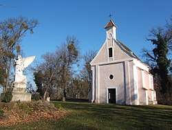 Chapel of Szőcsénypuszta | ||
| ||
 Somogyzsitfa Location of Somogyzsitfa | ||
| Coordinates: 46°32′54″N 17°18′02″E / 46.5483°N 17.30046°ECoordinates: 46°32′54″N 17°18′02″E / 46.5483°N 17.30046°E | ||
| Country |
| |
| Region | Southern Transdanubia | |
| County | Somogy | |
| District | Marcali | |
| RC Diocese | Kaposvár | |
| Area | ||
| • Total | 27.22 km2 (10.51 sq mi) | |
| Population (2017) | ||
| • Total | 583[1] | |
| Demonym(s) | zsitfai, somogyzsitfai | |
| Time zone | UTC+1 (CET) | |
| • Summer (DST) | UTC+2 (CEST) | |
| Postal code | 8734 | |
| Area code(s) | (+36) 85 | |
| NUTS 3 code | HU232 | |
| MP | József Attila Móring (KDNP) | |
| Website | Somogyzsitva Online | |
Somogyzsitfa (until 1950 as Somogyfehéregyháza and Felsőzsitva) is a village in Somogy county, Hungary. It consists of the two former villages of Somogyfehéregyháza and Felsőzsitva.
Etymology
Somogyfehéregyháza (English: Somogy white house) got its name after its whitewashed buildings or church during the Middle Ages. The name of Felsőzsitva consists of the Hungarian felső (English: upper) and the South Slavic zsitva (Hungarian: gabona, English: grain).[2]
External links
References


This article is issued from
Wikipedia.
The text is licensed under Creative Commons - Attribution - Sharealike.
Additional terms may apply for the media files.