Beleg, Hungary
| Beleg | |||
|---|---|---|---|
| Village | |||
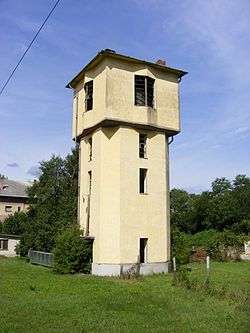 Water house of the railway station in Beleg | |||
| |||
 Beleg Location of Beleg, Hungary | |||
| Coordinates: 46°18′57″N 17°24′38″E / 46.31596°N 17.41058°ECoordinates: 46°18′57″N 17°24′38″E / 46.31596°N 17.41058°E | |||
| Country |
| ||
| Region | Southern Transdanubia | ||
| County | Somogy | ||
| District | Nagyatád | ||
| RC Diocese | Kaposvár | ||
| Area | |||
| • Total | 17.99 km2 (6.95 sq mi) | ||
| Population (2017) | |||
| • Total | 597[1] | ||
| Demonym(s) | belegi | ||
| Time zone | UTC+1 (CET) | ||
| • Summer (DST) | UTC+2 (CEST) | ||
| Postal code | 7543 | ||
| Area code(s) | (+36) 82 | ||
| NUTS 3 code | HU232 | ||
| MP | László Szászfalvi (KDNP) | ||
| Website | Beleg Online | ||
Etymology
Its name derives from the given name Biluk. He could be the owner of the village.[2]
History
According to László Szita the settlement was completely Hungarian in the 18th century.[3]
External links
References
| Town (1) |
| |
|---|---|---|
| Villages (17) | ||


This article is issued from
Wikipedia.
The text is licensed under Creative Commons - Attribution - Sharealike.
Additional terms may apply for the media files.