Gyugy
| Gyugy | |||
|---|---|---|---|
| Village | |||
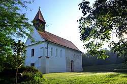 Church of Gyugy from the Árpád era | |||
| |||
 Gyugy Location of Gyugy | |||
| Coordinates: 46°41′30″N 17°41′01″E / 46.69164°N 17.68353°ECoordinates: 46°41′30″N 17°41′01″E / 46.69164°N 17.68353°E | |||
| Country |
| ||
| Region | Southern Transdanubia | ||
| County | Somogy | ||
| District | Fonyód | ||
| RC Diocese | Kaposvár | ||
| Area | |||
| • Total | 15.31 km2 (5.91 sq mi) | ||
| Population (2017) | |||
| • Total | 294[1] | ||
| Demonym(s) | gyugyi | ||
| Time zone | UTC+1 (CET) | ||
| • Summer (DST) | UTC+2 (CEST) | ||
| Postal code | 8692 | ||
| Area code(s) | (+36) 85 | ||
| NUTS 3 code | HU232 | ||
| MP | József Attila Móring (KDNP) | ||
| Website | Gyugy Online | ||
Sightseeings
Beautiful memorial of the village is the Árpád age church on the southern hills. It was renewed after an archaeological and architectural investigation in the last years. This church is a gem of the Somogy-side southern Balaton side.
External links
References
| Towns (4) |
| |
|---|---|---|
| Villages (17) | ||


This article is issued from
Wikipedia.
The text is licensed under Creative Commons - Attribution - Sharealike.
Additional terms may apply for the media files.