Kaposmérő
| Kaposmérő | |||
|---|---|---|---|
| Village | |||
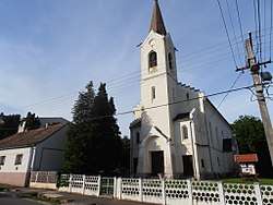 Reformed Church of Kaposmérő | |||
| |||
 Kaposmérő Location of Kaposmérő | |||
| Coordinates: 46°21′36″N 17°42′09″E / 46.36011°N 17.70243°ECoordinates: 46°21′36″N 17°42′09″E / 46.36011°N 17.70243°E | |||
| Country |
| ||
| Region | Southern Transdanubia | ||
| County | Somogy | ||
| District | Kaposvár | ||
| RC Diocese | Kaposvár | ||
| Area | |||
| • Total | 13.98 km2 (5.40 sq mi) | ||
| Population (2017) | |||
| • Total | 2,448[1] | ||
| Demonym(s) | mérői, kaposmérői | ||
| Time zone | UTC+1 (CET) | ||
| • Summer (DST) | UTC+2 (CEST) | ||
| Postal code | 7521 | ||
| Area code(s) | (+36) 82 | ||
| NUTS 3 code | HU232 | ||
| MP | Attila Gelencsér (Fidesz) | ||
| Website | Kaposmérő Online | ||

External links
References


This article is issued from
Wikipedia.
The text is licensed under Creative Commons - Attribution - Sharealike.
Additional terms may apply for the media files.