Újvárfalva
| Újvárfalva | ||
|---|---|---|
| Village | ||
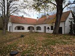 Noszlopy Mansion in Újvárfalva | ||
| ||
 Újvárfalva Location of Újvárfalva | ||
| Coordinates: 46°25′45″N 17°34′25″E / 46.42911°N 17.57367°ECoordinates: 46°25′45″N 17°34′25″E / 46.42911°N 17.57367°E | ||
| Country |
| |
| Region | Southern Transdanubia | |
| County | Somogy | |
| District | Kaposvár | |
| RC Diocese | Kaposvár | |
| Area | ||
| • Total | 12.22 km2 (4.72 sq mi) | |
| Population (2017) | ||
| • Total | 290[1] | |
| Demonym(s) | újvárfalvai, újvárfalusi | |
| Time zone | UTC+1 (CET) | |
| • Summer (DST) | UTC+2 (CEST) | |
| Postal code | 7436 | |
| Area code(s) | (+36) 82 | |
| NUTS 3 code | HU232 | |
| MP | József Attila Móring (KDNP) | |
| Website | Újvárfalva Online | |
External links
References


This article is issued from
Wikipedia.
The text is licensed under Creative Commons - Attribution - Sharealike.
Additional terms may apply for the media files.