Táska
| Táska | |||
|---|---|---|---|
| Village | |||
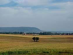 View of Táska | |||
| |||
 Táska Location of Táska | |||
| Coordinates: 46°37′01″N 17°31′29″E / 46.61701°N 17.52468°ECoordinates: 46°37′01″N 17°31′29″E / 46.61701°N 17.52468°E | |||
| Country |
| ||
| Region | Southern Transdanubia | ||
| County | Somogy | ||
| District | Marcali | ||
| RC Diocese | Kaposvár | ||
| Area | |||
| • Total | 25.98 km2 (10.03 sq mi) | ||
| Population (2017) | |||
| • Total | 386[1] | ||
| Demonym(s) | táskai | ||
| Time zone | UTC+1 (CET) | ||
| • Summer (DST) | UTC+2 (CEST) | ||
| Postal code | 8696 | ||
| Area code(s) | (+36) 85 | ||
| Patron Saint | Martin of Tours | ||
| NUTS 3 code | HU232 | ||
| MP | József Attila Móring (KDNP) | ||

External links
- Táska Official site.
- Street map (Hungarian)
References


This article is issued from
Wikipedia.
The text is licensed under Creative Commons - Attribution - Sharealike.
Additional terms may apply for the media files.