Nagyberény
| Nagyberény | |||
|---|---|---|---|
| Village | |||
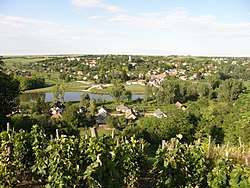 Houses of Nagyberény | |||
| |||
 Nagyberény Location of Nagyberény | |||
| Coordinates: 46°47′52″N 18°10′06″E / 46.79780°N 18.16841°ECoordinates: 46°47′52″N 18°10′06″E / 46.79780°N 18.16841°E | |||
| Country |
| ||
| Region | Southern Transdanubia | ||
| County | Somogy | ||
| District | Siófok | ||
| RC Diocese | Kaposvár | ||
| Area | |||
| • Total | 23.14 km2 (8.93 sq mi) | ||
| Population (2017) | |||
| • Total | 1,295[1] | ||
| Demonym(s) | berényi, nagyberényi | ||
| Time zone | UTC+1 (CET) | ||
| • Summer (DST) | UTC+2 (CEST) | ||
| Postal code | 8656 | ||
| Area code(s) | (+36) 84 | ||
| NUTS 3 code | HU232 | ||
| MP | Mihály Witzmann (Fidesz) | ||
| Website | Nagyberény Online | ||
History
According to László Szita the settlement was completely Hungarian in the 18th century.[2]
External links
References
Nagyberény's neighbours | ||||||||||
|---|---|---|---|---|---|---|---|---|---|---|
| ||||||||||
| Towns (3) |
| |
|---|---|---|
| Large village (1) | ||
| Villages (20) | ||


This article is issued from
Wikipedia.
The text is licensed under Creative Commons - Attribution - Sharealike.
Additional terms may apply for the media files.