Felsőmocsolád
| Felsőmocsolád | |||
|---|---|---|---|
| Village | |||
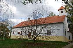 Roman Catholic Church of Felsőmocsolád (former Erőss Mansion) | |||
| |||
 Felsőmocsolád Location of Felsőmocsolád | |||
| Coordinates: 46°34′55″N 17°49′39″E / 46.58187°N 17.82762°ECoordinates: 46°34′55″N 17°49′39″E / 46.58187°N 17.82762°E | |||
| Country |
| ||
| Region | Southern Transdanubia | ||
| County | Somogy | ||
| District | Kaposvár | ||
| RC Diocese | Kaposvár | ||
| Government | |||
| • Mayor | Tamás Mocsai | ||
| Area | |||
| • Total | 16.51 km2 (6.37 sq mi) | ||
| Population (2017) | |||
| • Total | 361[1] | ||
| Demonym(s) | mocsoládi, felsőmocsoládi | ||
| Time zone | UTC+1 (CET) | ||
| • Summer (DST) | UTC+2 (CEST) | ||
| Postal code | 7456 | ||
| Area code(s) | (+36) 82 | ||
| NUTS 3 code | HU232 | ||
| MP | Mihály Witzmann (Fidesz) | ||
| Website | Felsőmocsolád Online | ||
Etymology
Its name derives from the world mocsola older version of the Hungarian mocsár (English: marsh). So Felsőmocsolád consists of felső (English: upper), mocsola and -d suffix.[2]
External links
References


This article is issued from
Wikipedia.
The text is licensed under Creative Commons - Attribution - Sharealike.
Additional terms may apply for the media files.