Somodor
| Somodor | |||
|---|---|---|---|
| Village | |||
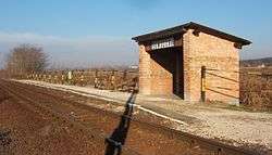 Train station of Somodor | |||
| |||
 Somodor Location of Somodor | |||
| Coordinates: 46°28′31″N 17°50′36″E / 46.47530°N 17.84323°ECoordinates: 46°28′31″N 17°50′36″E / 46.47530°N 17.84323°E | |||
| Country |
| ||
| Region | Southern Transdanubia | ||
| County | Somogy | ||
| District | Kaposvár | ||
| RC Diocese | Kaposvár | ||
| Area | |||
| • Total | 19.91 km2 (7.69 sq mi) | ||
| Population (2017) | |||
| • Total | 364[1] | ||
| Demonym(s) | somodori | ||
| Time zone | UTC+1 (CET) | ||
| • Summer (DST) | UTC+2 (CEST) | ||
| Postal code | 7454 | ||
| Area code(s) | (+36) 82 | ||
| NUTS 3 code | HU232 | ||
| MP | Mihály Witzmann (Fidesz) | ||
| Website | Somodor Online | ||
History
According to László Szita the settlement was completely Hungarian in the 18th century.[2]
External links
References


This article is issued from
Wikipedia.
The text is licensed under Creative Commons - Attribution - Sharealike.
Additional terms may apply for the media files.