Szenta
| Szenta | |||
|---|---|---|---|
| Village | |||
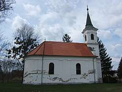 Reformed Church in Szenta | |||
| |||
 Szenta Location of Szenta | |||
| Coordinates: 46°15′06″N 17°10′20″E / 46.25163°N 17.17223°ECoordinates: 46°15′06″N 17°10′20″E / 46.25163°N 17.17223°E | |||
| Country |
| ||
| Region | Southern Transdanubia | ||
| County | Somogy | ||
| District | Csurgó | ||
| RC Diocese | Kaposvár | ||
| Area | |||
| • Total | 64.47 km2 (24.89 sq mi) | ||
| Population (2017) | |||
| • Total | 375[1] | ||
| Demonym(s) | szentai | ||
| Time zone | UTC+1 (CET) | ||
| • Summer (DST) | UTC+2 (CEST) | ||
| Postal code | 8849 | ||
| Area code(s) | (+36) 82 | ||
| NUTS 3 code | HU232 | ||
| MP | László Szászfalvi (KDNP) | ||
External links
References
| Town (1) |
| |
|---|---|---|
| Large village (1) | ||
| Villages (16) | ||


This article is issued from
Wikipedia.
The text is licensed under Creative Commons - Attribution - Sharealike.
Additional terms may apply for the media files.