Bélavár
| Bélavár Belovar (in Croatian) | |||
|---|---|---|---|
| Village | |||
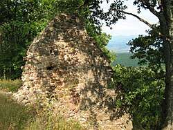 Ruins of Bélavár Castle | |||
| |||
 Bélavár Location of Bélavár | |||
| Coordinates: 46°07′19″N 17°13′10″E / 46.12191°N 17.21942°ECoordinates: 46°07′19″N 17°13′10″E / 46.12191°N 17.21942°E | |||
| Country |
| ||
| Region | Southern Transdanubia | ||
| County | Somogy | ||
| District | Barcs | ||
| RC Diocese | Kaposvár | ||
| Area | |||
| • Total | 22.78 km2 (8.80 sq mi) | ||
| Population (2017) | |||
| • Total | 317[1] | ||
| Demonym(s) | bélavári | ||
| Time zone | UTC+1 (CET) | ||
| • Summer (DST) | UTC+2 (CEST) | ||
| Postal code | 7589 | ||
| Area code(s) | (+36) 82 | ||
| NUTS 3 code | HU232 | ||
| MP | László Szászfalvi (KDNP) | ||
| Website | Bélavár Online | ||
Bélavár (Croatian: Belovar) is a village in Somogy county, Hungary.
Etymology
Its name consists of two worlds. Béla is a Hungarian person name. Bélavár (English: Béla Castle) could be the name of a castle of a person called Béla near the settlement.[2]
References
External links
| Town (1) |
| |
|---|---|---|
| Villages (25) | ||


This article is issued from
Wikipedia.
The text is licensed under Creative Commons - Attribution - Sharealike.
Additional terms may apply for the media files.