Saint-Vérand, Saône-et-Loire
| Saint-Vérand | |
|---|---|
| Commune | |
 | |
 Saint-Vérand Location within Bourgogne-Franche-Comté region  Saint-Vérand | |
| Coordinates: 46°15′19″N 4°44′10″E / 46.2553°N 4.7361°ECoordinates: 46°15′19″N 4°44′10″E / 46.2553°N 4.7361°E | |
| Country | France |
| Region | Bourgogne-Franche-Comté |
| Department | Saône-et-Loire |
| Arrondissement | Mâcon |
| Canton | La Chapelle-de-Guinchay |
| Area1 | 2.45 km2 (0.95 sq mi) |
| Population (2006)2 | 192 |
| • Density | 78/km2 (200/sq mi) |
| Time zone | UTC+1 (CET) |
| • Summer (DST) | UTC+2 (CEST) |
| INSEE/Postal code | 71487 /71570 |
| Elevation |
220–475 m (722–1,558 ft) (avg. 350 m or 1,150 ft) |
|
1 French Land Register data, which excludes lakes, ponds, glaciers > 1 km2 (0.386 sq mi or 247 acres) and river estuaries. 2 Population without double counting: residents of multiple communes (e.g., students and military personnel) only counted once. | |
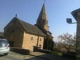
Saint-Vérand is a commune in the Saône-et-Loire department in the region of Bourgogne in eastern France.
Wine
After the Revolution of 1789, the commune decided on the name Saint Vérand with a "d" at the end, following an administrative error.[1] Saint-Vérand and surrounding communes produce white Burgundy wine under the appellation Saint-Véran, using Saint-Vérands old spelling, without 'd'.
See also
References
| Wikimedia Commons has media related to Saint-Vérand (Saône-et-Loire). |
This article is issued from
Wikipedia.
The text is licensed under Creative Commons - Attribution - Sharealike.
Additional terms may apply for the media files.