Pressy-sous-Dondin
| Pressy-sous-Dondin | |
|---|---|
| Commune | |
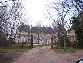 Chateau | |
 Pressy-sous-Dondin Location within Bourgogne-Franche-Comté region  Pressy-sous-Dondin | |
| Coordinates: 46°28′32″N 4°30′42″E / 46.4756°N 4.5117°ECoordinates: 46°28′32″N 4°30′42″E / 46.4756°N 4.5117°E | |
| Country | France |
| Region | Bourgogne-Franche-Comté |
| Department | Saône-et-Loire |
| Arrondissement | Mâcon |
| Canton | Cluny |
| Area1 | 12.38 km2 (4.78 sq mi) |
| Population (2006)2 | 93 |
| • Density | 7.5/km2 (19/sq mi) |
| Time zone | UTC+1 (CET) |
| • Summer (DST) | UTC+2 (CEST) |
| INSEE/Postal code | 71358 /71220 |
| Elevation |
236–445 m (774–1,460 ft) (avg. 315 m or 1,033 ft) |
|
1 French Land Register data, which excludes lakes, ponds, glaciers > 1 km2 (0.386 sq mi or 247 acres) and river estuaries. 2 Population without double counting: residents of multiple communes (e.g., students and military personnel) only counted once. | |
Pressy-sous-Dondin is a commune in the Saône-et-Loire department in the region of Bourgogne-Franche-Comté in eastern France.
See also
References
| Wikimedia Commons has media related to Pressy-sous-Dondin. |
This article is issued from
Wikipedia.
The text is licensed under Creative Commons - Attribution - Sharealike.
Additional terms may apply for the media files.