Arrondissement of Mâcon
| Mâcon | |
|---|---|
| Arrondissement | |
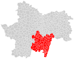 Location of the arrondissement in Saône-et-Loire | |
| Country | France |
| Region | Bourgogne-Franche-Comté |
| Department | Saône-et-Loire |
| Communes | 122 |
| Prefecture | Mâcon |
| Population (2013) | |
| • Total | 113,665 |
| ¹ French Land Register data, which exclude lakes, ponds, and glaciers larger than 1 km² as well as the estuaries of rivers. | |
The arrondissement of Mâcon is an arrondissement in the department of Saône-et-Loire, in the French region of Bourgogne-Franche-Comté. Since the January 2017 reorganization of the arrondissements of Saône-et-Loire, it has 122 communes.[1]
Composition
Cantons
The cantons of the arrondissement of Mâcon are:
Communes
The communes of the arrondissement of Mâcon, and their INSEE codes, are:
- Ameugny (71007)
- Azé (71016)
- Bergesserin (71030)
- Berzé-la-Ville (71032)
- Berzé-le-Châtel (71031)
- Bissy-la-Mâconnaise (71035)
- Blanot (71039)
- Bonnay (71042)
- Bourgvilain (71050)
- Brandon (71055)
- Bray (71057)
- Buffières (71065)
- Burgy (71066)
- Burzy (71068)
- Bussières (71069)
- Chaintré (71074)
- Chânes (71084)
- La Chapelle-de-Guinchay (71090)
- La Chapelle-du-Mont-de-France (71091)
- La Chapelle-sous-Brancion (71094)
- Charbonnières (71099)
- Chardonnay (71100)
- Charnay-lès-Mâcon (71105)
- Chasselas (71108)
- Château (71112)
- Chérizet (71125)
- Chevagny-les-Chevrières (71126)
- Chevagny-sur-Guye (71127)
- Chiddes (71128)
- Chissey-lès-Mâcon (71130)
- Clermain (71134)
- Clessé (71135)
- Cluny (71137)
- Cortambert (71146)
- Cortevaix (71147)
- Crêches-sur-Saône (71150)
- Cruzille (71156)
- Curtil-sous-Buffières (71163)
- Davayé (71169)
- Dompierre-les-Ormes (71178)
- Donzy-le-Pertuis (71181)
- Farges-lès-Mâcon (71195)
- Flagy (71199)
- Fleurville (71591)
- Fuissé (71210)
- Germolles-sur-Grosne (71217)
- Grevilly (71226)
- La Guiche (71231)
- Hurigny (71235)
- Igé (71236)
- Jalogny (71240)
- Joncy (71242)
- Lacrost (71248)
- Laizé (71250)
- Leynes (71258)
- Lournand (71264)
- Lugny (71267)
- Mâcon (71270)
- Martailly-lès-Brancion (71284)
- Massilly (71287)
- Matour (71289)
- Mazille (71290)
- Milly-Lamartine (71299)
- Montagny-sur-Grosne (71304)
- Montbellet (71305)
- Montmelard (71316)
- Ozenay (71338)
- Passy (71344)
- Péronne (71345)
- Pierreclos (71350)
- Plottes (71353)
- Pressy-sous-Dondin (71358)
- Préty (71359)
- Prissé (71360)
- Pruzilly (71362)
- La Roche-Vineuse (71371)
- Romanèche-Thorins (71372)
- Royer (71377)
- Sailly (71381)
- Saint-Albain (71383)
- Saint-Amour-Bellevue (71385)
- Saint-André-le-Désert (71387)
- Saint-Clément-sur-Guye (71400)
- Sainte-Cécile (71397)
- Saint-Gengoux-de-Scissé (71416)
- Saint-Huruge (71427)
- Saint-Léger-sous-la-Bussière (71441)
- Saint-Marcelin-de-Cray (71446)
- Saint-Martin-Belle-Roche (71448)
- Saint-Martin-de-Salencey (71452)
- Saint-Martin-la-Patrouille (71458)
- Saint-Maurice-de-Satonnay (71460)
- Saint-Pierre-le-Vieux (71469)
- Saint-Point (71470)
- Saint-Symphorien-d'Ancelles (71481)
- Saint-Vérand (71487)
- Saint-Vincent-des-Prés (71488)
- Saint-Ythaire (71492)
- La Salle (71494)
- Salornay-sur-Guye (71495)
- Sancé (71497)
- Senozan (71513)
- Serrières (71518)
- Sigy-le-Châtel (71521)
- Sivignon (71524)
- Sologny (71525)
- Solutré-Pouilly (71526)
- Taizé (71532)
- Tournus (71543)
- Tramayes (71545)
- Trambly (71546)
- Trivy (71547)
- La Truchère (71549)
- Uchizy (71550)
- Varennes-lès-Mâcon (71556)
- Vergisson (71567)
- Verosvres (71571)
- Verzé (71574)
- Le Villars (71576)
- La Vineuse sur Fregande (71582)
- Vinzelles (71583)
- Viré (71584)
References
- ↑ "Arrêté préfectoral, 6 January 2017" (PDF). Retrieved 2017-08-02.
External links
This article is issued from
Wikipedia.
The text is licensed under Creative Commons - Attribution - Sharealike.
Additional terms may apply for the media files.