Montagny-sur-Grosne
| Montagny-sur-Grosne | |
|---|---|
| Commune | |
 | |
 Montagny-sur-Grosne Location within Bourgogne-Franche-Comté region  Montagny-sur-Grosne | |
| Coordinates: 46°21′24″N 4°33′03″E / 46.3567°N 4.5508°ECoordinates: 46°21′24″N 4°33′03″E / 46.3567°N 4.5508°E | |
| Country | France |
| Region | Bourgogne-Franche-Comté |
| Department | Saône-et-Loire |
| Arrondissement | Mâcon |
| Canton | La Chapelle-de-Guinchay |
| Area1 | 6.84 km2 (2.64 sq mi) |
| Population (2006)2 | 86 |
| • Density | 13/km2 (33/sq mi) |
| Time zone | UTC+1 (CET) |
| • Summer (DST) | UTC+2 (CEST) |
| INSEE/Postal code | 71304 /71520 |
| Elevation |
283–535 m (928–1,755 ft) (avg. 420 m or 1,380 ft) |
|
1 French Land Register data, which excludes lakes, ponds, glaciers > 1 km2 (0.386 sq mi or 247 acres) and river estuaries. 2 Population without double counting: residents of multiple communes (e.g., students and military personnel) only counted once. | |
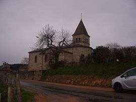
Montagny-sur-Grosne is a commune in the Saône-et-Loire department in the region of Bourgogne-Franche-Comté in eastern France.
Geography
The river Grosne forms part of the commune's eastern border. Surrounded by acres of beechwood and Douglas fir plantation, this little village with its own microclimate sits on the hill and looks southward toward the Chateau d'Ouilly. The town is renowned locally for its annual fête du pain (bread festival), during which the villagers and nearby residents meet at a baker's with a large wood oven. Everybody brings food, pastry, pizzas and bread to cook in the oven, which has been stoked with wood from the forest. People will then either sample some of the Beaujolais wine grown only a few kilometres away across the Fut D'Avenas or enjoy some of the meandering walking trails criss-crossing the countryside.
See also
References
External links
| Wikimedia Commons has media related to Montagny-sur-Grosne. |