Saint-Loup-de-Varennes
| Saint-Loup-de-Varennes | |
|---|---|
| Commune | |
 A sign showing the name of the inventor of photography | |
 Saint-Loup-de-Varennes Location within Bourgogne-Franche-Comté region  Saint-Loup-de-Varennes | |
| Coordinates: 46°43′43″N 4°51′41″E / 46.7286°N 4.8614°ECoordinates: 46°43′43″N 4°51′41″E / 46.7286°N 4.8614°E | |
| Country | France |
| Region | Bourgogne-Franche-Comté |
| Department | Saône-et-Loire |
| Arrondissement | Chalon-sur-Saône |
| Canton | Saint-Rémy |
| Intercommunality | Le grand Chalon |
| Government | |
| • Mayor | Francis Debras |
| Area1 | 8.32 km2 (3.21 sq mi) |
| Population (2006)2 | 1,146 |
| • Density | 140/km2 (360/sq mi) |
| Time zone | UTC+1 (CET) |
| • Summer (DST) | UTC+2 (CEST) |
| INSEE/Postal code | 71444 /71240 |
| Elevation |
171–205 m (561–673 ft) (avg. 191 m or 627 ft) |
|
1 French Land Register data, which excludes lakes, ponds, glaciers > 1 km2 (0.386 sq mi or 247 acres) and river estuaries. 2 Population without double counting: residents of multiple communes (e.g., students and military personnel) only counted once. | |
Saint-Loup-de-Varennes is a commune in the Saône-et-Loire department in the region of Bourgogne in eastern France.
Geography
It is 6 km (3.7 mi) south of the centre of Chalon-sur-Saône.
Historical Significance
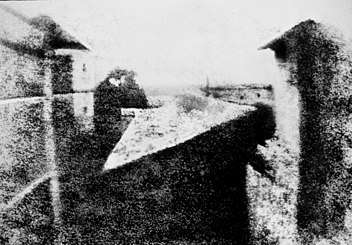
View from the Window at Le Gras, one of Nicéphore Niépce's earliest surviving photographs
Nicéphore Niépce, the inventor of photography, lived in Saint-Loup-de-Varennes, where he died in 1833. Most or all of his photographs, including one taken in 1827 and now the oldest known surviving camera photograph, were made at Le Gras, his ancestral family estate in this village.
See also
References
- INSEE
- Niépce website (in French)
External links
| Wikimedia Commons has media related to Saint-Loup-de-Varennes. |
This article is issued from
Wikipedia.
The text is licensed under Creative Commons - Attribution - Sharealike.
Additional terms may apply for the media files.