Cluny
| Cluny | ||
|---|---|---|
| Commune | ||
 | ||
| ||
 Cluny Location within Bourgogne-Franche-Comté region  Cluny | ||
| Coordinates: 46°26′07″N 4°39′36″E / 46.4353°N 4.66°ECoordinates: 46°26′07″N 4°39′36″E / 46.4353°N 4.66°E | ||
| Country | France | |
| Region | Bourgogne-Franche-Comté | |
| Department | Saône-et-Loire | |
| Arrondissement | Mâcon | |
| Canton | Cluny | |
| Government | ||
| • Mayor (2008–2015) | Jean-Luc Delpeuch | |
| Area1 | 23.71 km2 (9.15 sq mi) | |
| Population (2006)2 | 4,835 | |
| • Density | 200/km2 (530/sq mi) | |
| Time zone | UTC+1 (CET) | |
| • Summer (DST) | UTC+2 (CEST) | |
| INSEE/Postal code | 71137 /71250 | |
| Elevation |
226–574 m (741–1,883 ft) (avg. 248 m or 814 ft) | |
|
1 French Land Register data, which excludes lakes, ponds, glaciers > 1 km2 (0.386 sq mi or 247 acres) and river estuaries. 2 Population without double counting: residents of multiple communes (e.g., students and military personnel) only counted once. | ||

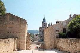
Cluny is a commune in the eastern French department of Saône-et-Loire, in the region of Bourgogne-Franche-Comté. It is 20 km (12 mi) northwest of Mâcon.
The town grew up around the Benedictine Abbey of Cluny, founded by Duke William I of Aquitaine in 910. The height of Cluniac influence was from the second half of the 10th century through the early 12th. The abbey was sacked by the Huguenots in 1562, and many of its valuable manuscripts were destroyed or removed.
Geography
The river Grosne flows northward through the commune and crosses the town.
Tourism
Bourgogne-Franche-Comté has a large number of places which are of interest to tourists, such as:
- The Arboretum de Pézanin, one of the richest arboreta in France
- Mâcon
- Paray-le-Monial
- The Green Way
See also
References
External links
| Wikimedia Commons has media related to Cluny. |
- Official website (in French)
- Paradoxplace – Cluny Page – Photos
| Authority control |
|---|