Ratenelle
| Ratenelle | |
|---|---|
| Commune | |
 | |
 Ratenelle Location within Bourgogne-Franche-Comté region  Ratenelle | |
| Coordinates: 46°31′40″N 5°01′01″E / 46.5278°N 5.0169°ECoordinates: 46°31′40″N 5°01′01″E / 46.5278°N 5.0169°E | |
| Country | France |
| Region | Bourgogne-Franche-Comté |
| Department | Saône-et-Loire |
| Arrondissement | Louhans |
| Canton | Cuiseaux |
| Area1 | 8.03 km2 (3.10 sq mi) |
| Population (2006)2 | 364 |
| • Density | 45/km2 (120/sq mi) |
| Time zone | UTC+1 (CET) |
| • Summer (DST) | UTC+2 (CEST) |
| INSEE/Postal code | 71366 /71290 |
| Elevation |
171–196 m (561–643 ft) (avg. 179 m or 587 ft) |
|
1 French Land Register data, which excludes lakes, ponds, glaciers > 1 km2 (0.386 sq mi or 247 acres) and river estuaries. 2 Population without double counting: residents of multiple communes (e.g., students and military personnel) only counted once. | |
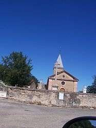
Ratenelle is a commune in the Saône-et-Loire department in the region of Bourgogne in eastern France.
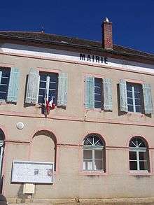
Town hall
See also
References
| Wikimedia Commons has media related to Ratenelle. |
This article is issued from
Wikipedia.
The text is licensed under Creative Commons - Attribution - Sharealike.
Additional terms may apply for the media files.